NV GOLD CORP, SLUMBER GOLD PROJECT
The Slumber Gold Project covers an area about 3.9 square kilometers comprised of 55 unpatented lode mining claims owned by the company and 5 unpatented lode mining claims leased from a third party.
The Slumber Gold Project occurs along an intra-mountain graben in the Jackson Mountains approximately 50 miles northwest of Winnemucca, Humboldt County, Nevada and is approximately 21 miles west of the Sleeper bonanza epithermal vein gold deposit. Slumber is one of several high-level epithermal gold systems on a trend from the Jackson Mountains, through the Bilk Creek Mountains and continuing north into Oregon. These deposits, along with the Sleeper, Sulphur-Hycroft, Goldbanks, Blue Mountain, Sandman, and other precious metals deposits located along the western splays and associated fault-fracture zones of the mid-Miocene (Tertiary) Northern Nevada Rift, define an important epithermal province in northwestern Nevada.
Highlights of Slumber Gold Project and July 2020 CSAMT Geophysical Program
- Preliminary 2019 exploration drill program identified a potentially large, buried gold-bearing hot spring system.
- Newly acquired CSAMT survey data compliment earlier gravity and ground magnetic geophysical data as well as drilling results from late 2019.
- CSAMT survey identifies multiple high priority drill targets thought to be associated with the hydrothermal plumbing of the hot spring system.
- NV Gold now interprets that its 2019 drill holes stopped short of these newly identified high priority targets. 2020 drill holes did not reach depth due to excess water in the RC holes. The Company is planning a deep dore hole program to test these structures.
Important geologic features observed at Slumber include outcrops of chalcedony-cemented conglomerate and sandstone with textures consistent with sinter-cemented sediment overlying modern geothermal systems and with outcrops found over other epithermal mineral systems. These rocks display elevated concentrations of gold and pathfinder elements. Chalcedony-cemented conglomerate overlies a stratigraphic section comprised of Tertiary rhyolite tuff and tuffaceous sedimentary rocks that infill a northeast-trending graben and unconformably overlie pre-Tertiary basement rocks. Previous exploration drilling (1985-93), focused on shallow bulk-minable gold mineralization, consisted of 15 shallow (average depth ~115 m) vertical reverse-circulation (“RC”) holes drilled on or near these silicified outcrops. Seven of fifteen holes contained anomalous gold intercepts of 0.3 g Au/t over thicknesses ranging from 2-32 m.
In 2019, NV Gold completed an initial 7-hole, 1,091 m drill test of the Slumber Gold Project. The drill program was driven by surface geological evidence and available geophysical information. The program encountered anomalous gold mineralization in four of the seven holes. The most notable intercept was a 39.6 m interval grading 0.34 g Au/t and 1.3 g Ag/t beginning at 36.6 m down hole, including 22.8 m grading 0.47 g Au/t and 1.6 g Ag/t beginning at 53.4 m down hole encountered in hole SL-02. Hole SL-01, situated approximately 450 m northeast of hole SL-02, encountered five mineralized intervals from surface to 167.7 m. Mineralization remained open in all directions around these holes.
Encouraged by the results of the initial 2019 drill program, NV Gold contracted a CSAMT survey of the project area to assist in drill targeting at depth.
Zonge International of Reno, Nevada, performed the CSAMT (controlled source audio-magnetotelluric) survey on the Slumber Gold Project area in September 2020. The survey was completed with data acquisition along 6 lines, each 1000 m in length, spaced at 200 m apart, with a station-spacing along lines of 25 m. The data quality was considered to be of good to excellent quality. The CSAMT survey data complements the known gravity, ground magnetic geophysical surveys, and drilling conducted in late 2019.
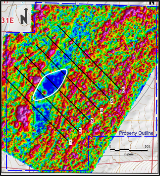
Figure 1:Map of Slumber project area, colored by the Analytic Signal of Total Magnetic Intensity. The white ellipse highlights the area of low magnetic response, interpreted to reflect magnetite-destructive hydrothermal alteration. Black lines are the lines of the CSAMT survey.
Subsequently, Thomas V Weiss and Associates Inc. of Centennial, Colorado, was engaged to complete a comprehensive geophysical interpretation incorporating the gravity, ground magnetic and CSAMT geophysical datasets. Results of the three surveys provided extensive complementary information to generate the cross section maps of the Slumber Gold Project area geology at depth.
The ground magnetic survey highlighted an elliptical area of low magnetic response, and was interpreted to be due to magnetite-destructive hydrothermal alteration. The form of the magnetic anomaly suggests a central area of dilation within a larger zone of structural deformation (Figure 1). High-grade ore shoots in epithermal deposits frequently are concentrated in dilatant zones along faults. This zone is now a priority exploration target.
Interpretation of the new CSAMT data highlights several high-angle high-resistivity zones within a north-northeast-oriented focus area generally coincident with the area of reduced magnetic response. Such high-resistivity zones, surrounded by zones of greater conductivity, are a key feature characteristic of epithermal veins. These relationships are illustrated on one representative geophysical cross-section in Figure 2. Similar features are present on five of the six CSAMT lines.
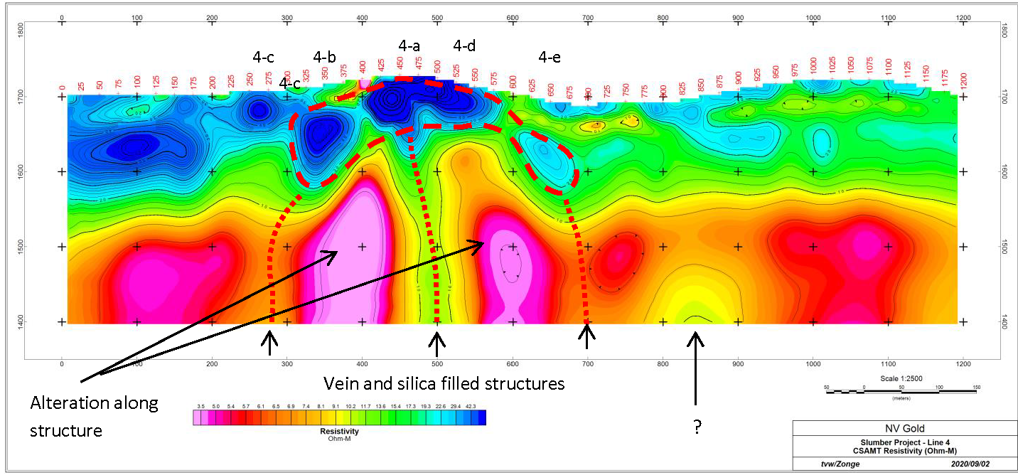
Figure 2. Slumber Project Area CSAMT Line 4 viewed looking northeast. Cooler colors image rock masses with greater resistivity. The image has been interpreted to show several high-angle resistive zones, surrounded by more conductive rock. The blue resistive cap corresponds to silicified outcrops.
When compared to past drilling, the new model suggests that past drilling, primarily targeted by surface geologic features, did not test deep enough as illustrated in Figure 3.
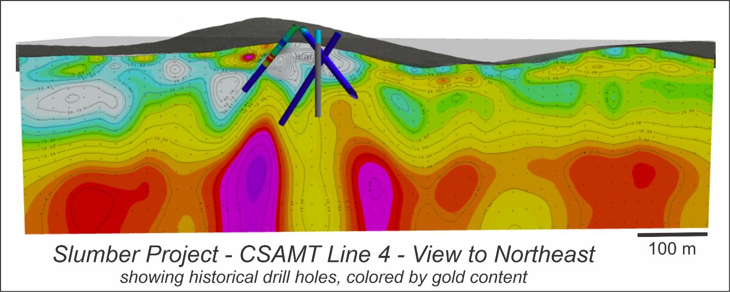
Figure 3: Slumber Project Area CSAMT Line 4 viewed looking northeast. Cooler colors image rock masses with greater resistivity. The traces of several historic drill holes are shown and indicates that the holes were not drilled deep enough to intersect possible zones of high-angle veining and mineralization.
Based upon the integrated interpretation of the known geology and geophysics, the NV Gold technical team and Board Directors, consisting of Dr. Quinton Hennigh and Dr. Odin Christensen, are finalizing the fall drill program to test the potential identified deeper targets. The Phase 2 drill program consisted of nine (9) RC drill holes totalling 1859 m or 6100 ft.
Key Highlights from Phase 2 Drill Program at Slumber Gold Project
- Drilling has outlined a new 600 meter-wide mineralized oxide gold zone close to surface with notable drill intercepts, including a very encouraging 18.3 m @ 0.52 g/t Aubeginning at 48.7 m in Hole SL-11, and hosted in an oxidized and silicified rhyolite which correlates with a resistive blanket as seen in CSAMT data (please refer to Figure 1). Another hole, SL-14, intersected134.2m @ 0.14 g/t Au starting from surface.
- The near surface oxidized gold intersection is of signficance noting Argonaut Gold (U.S.) Corp.’s Florida Canyon Gold Mine, down the highway from Slumber, is in operation with reserves grading 0.43 g/t Au.
- This newly discovered zone is separate from that discovered during the 2019 drill program, and will be prioritized for follow up work in 2021.
- Recent stream sediment and rock chip sampling has identified two additional parallel structures which remain untested.
- The source of the mineralized resistive blanket is believed to be higher grade feeder structures at depth.
- As previously reported, due to unexpected high volumes of ground water, priority targets in drill holes SL-9, SL-10, SL-13, SL-14, SL-15 and SL-16 were not adequately tested, due to the holes being terminated short of planned depth (refer to Figure 2 below).
- The primary CSAMT-interpreted targets, where NV Gold was targeting a potential “Sleeper-type” gold system at Slumber, remain untested.
About CSAMT
The various measured electrical and magnetic responses from a CSAMT survey are used to model the resistivity structure of the earth, which relates directly to the underlying geology. CSAMT is highly effective in the exploration of epithermal systems such as Slumber, and assists in identifying areas of silicification that develop within the structural conduits of hot-spring systems (places where mineralized veins might be found).
CSAMT assists in the vertical geophysical mapping of a project in the 20-1000-m depth range. The prospective boiling zone, where high-grade mineralization can occur within an epithermal system, is commonly believed to exist at depths ranging from 300-500 m below the paleo-surface. The high-grade centers of low-sulfidation epithermal precious-metal deposits can be relatively small exploration targets, surrounded by much larger volumes of altered and geochemically anomalous rock, making precise drill targeting critical.
Important geologic features observed at Slumber include:
- Hydrothermal alteration, principally in the form of silicification, associated with widespread gold mineralization that is hosted by a series of Tertiary tuffs and tuffaceous sediments that infill a northerly- trending graben and unconformably overlie pre-Tertiary basement rocks.
- Two or more, northeast-trending erosional windows of gold-bearing, multi-phased, hydrothermally silicified zones exhibiting crosscutting quartz veining, hydrothermal brecciation, and oxidized pyrite exposed through and surrounded by alluvium.
- Rock chip gold values of up to +1.0 ppm associated with anomalous Ag, As, Sb, and Hg collected from exposed silicified zones. Soil geochemical anomalies exhibit a NE trend and are parallel to the strike of the silicified zones and mineralized fractures.
- Mineralized pieces of quartz vein float occurring in an alluvial-filled valley located east of the southern silicified zone (Rattlesnake Knob). This material exhibits classic high-level epithermal features including multi-phase banding, comb and cockade quartz textures.
- Previous exploration (1985-93) that was focused on shallow bulk-minable gold mineralization and consisted of 15 shallow (average depth ~380’) vertical reverse circulation holes focused on and near these silicified outcrops. Seven of fifteen holes contained anomalous gold intercepts of +0.010 oz/t Au over a thickness ranging from 5 to 105 feet. Drilling was focused exclusively on and near the silicified outcrops, yet ground-based geophysics suggests that several additional targets occur under alluvium east of the outcrops and remain undrilled.
- Widespread hydrothermal alteration (multi-phase silicification and hydrothermal breccia) containing a significant thickness of anomalous gold mineralization and demonstrating that the system is a robust, gold-bearing system exhibiting similar features to those associated with bonanza style epithermal veins at the nearby Sleeper and Sandman-Blue Mtn.
- Other low-sulfidation epithermal precious metals properties occurring along the east flank of the Jackson Mountains and further north along the rift zone including the Bottle Creek and Happy Creek properties in the Bottle Creek district; the Quinn property at the north end of the Jackson Mtns; and others continuing north into Oregon.
NV Gold completed two detailed ground geophysical surveys over the Slumber project area in 2019. A gravity survey, with 200-meter station spacing, and a ground magnetic survey, with 25-meter line spacing, were completed by Magee Geophysical Services of Reno, Nevada. The geophysical surveys cover an area of about 4 square kilometers. The data from both surveys were processed by Thomas V. Weis and Associates of Centennial, Colorado.
The gravity and ground magnetic surveys paint complementary images of the structure and nature of bedrock geology hidden at depth beneath the Slumber project area. The gravity interpretation indicates the presence of a broad NNE-trending bedrock trough, crossed by two deeper NE-trending fault-bounded basins. The magnetic data outline a distinct area of greatly reduced magnetic susceptibility (Figure 1A), which is interpreted to indicate a zone of hydrothermal alteration. The magnetic low measures about 2000 meters long by 300 meters wide, elongate in a NNE direction and coincident with the gravity low.
Figure 1: Comparison of Slumber and Sleeper Gold Projects

Widespread hydrothermal alteration (multi-phase silicification in outcrop and hydrothermal breccia seen in float) containing significant thicknesses of elevated gold mineralization in historic drilling demonstrate that the system is robust and gold-bearing, with features similar to those associated with bonanza style epithermal veins at the nearby Sleeper and Sandman-Blue Mountain area deposits. Sleeper, located 35 kilometers to the east, produced 2.3 million ounces of silver and 1.68 million ounces of gold from 1986 to 1996).
In the case of Slumber, the Company’s recent magnetic and gravity geophysical surveys have identified at least one clearly developed and altered, lens-shaped zone at the center of our target zone (Fig. 1). Our knowledge of this type of structural setting will assist in identifying the best areas for potential localization of high-grade gold and/or silver mineralization, and with calculating drill targets. The Company interprets the magnetic-low as an altered and mineralized lens, with magnetite-destructive alteration as the source for the anomaly.
Detailed features in the magnetic data indicate the presence of a set of NNE-striking basin-bounding normal faults. The geophysical surveys highlight hidden structural discontinuities, possible conduits for hydrothermal fluids, and a significant area of interpreted hydrothermal alteration.
Refer to press release dated May 20, 2021 for information on future drill targeting. The project is nwo planned for a Phase 3 drill program in 2021