DEWDNEY TRAIL PROJECT
History
Placer gold provided the first exploration interest in the area starting in the mid to late nineteenth century, with deposits on the Wild Horse River proving large and profitable. Anecdotal information suggests at least 1.5 million ounces (46.7 million grams) of gold have been recovered; however, no corresponding lode deposits of any size have been discovered, suggesting the gold potential of the Wildhorse Creek Area has undeveloped potential.
The Dewdney Trail Property is located upstream from placer deposits in Wildhorse Creek and may host the source of the placer gold.
Exploration on the Dewdney Trail Project prior to its acquisition by SG Spirit Gold Inc, and subsequent option to PJX in 2010 consisted of: (i) prospecting; (ii) follow-up (confirmatory) soil geochemistry; (iii) rock geochemistry; (iv) trenching, (v) data compilation into GIS format; (vi) geological mapping; and (vii) small drill programs on three of the five showings located on the Dewdney Trail Project: Tac, Jack Leg and Dew Drop. The Spirit and Lewis showings have never been drilled.
In October, 2010, PJX contracted Aeroquest Airborne to conduct detailed 75 m line-spacing airborne geophysical (Electromagnetic and Magnetic) test surveys over the 5 showing areas of the Dewdney Trail Property.
In December, 2010, Robert Thompson (PGeo) completed an NI 43-101 Technical Report on the Dewdney Trail Property for the Company.
The Dewdney Trail Project comprises 36 contiguous mineral tenures covering approximately 13,043 ha located in the western Rocky Mountains of southeastern British Columbia adjacent to the Rocky Mountain Trench. It is accessible using two major logging road systems off highway 93 where it parallels the eastern margin of the Kootenay River.
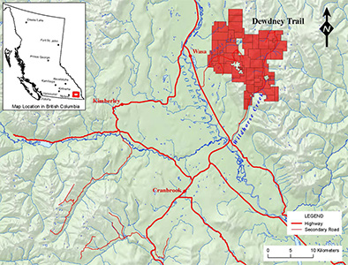
The town of Kimberley is located 32 km to the west on the far side of the Rocky Mountain Trench; the town of Cranbrook is located 29 km to the south west; and the village of Wasa, is 10 km to the west on the eastern margin of the trench (see Figure 4-1).
Figure 4-1: Location of the Dewdney Trail Project mineral tenures in the western Rocky Mountains of southeastern British Columbia, Canada.
The towns of Kimberley and Cranbrook are the nearest major supply centres where material and services adequate to explore the Dewdney Trail Project can be found. Infrastructure resources are excellent and readily available. The Dewdney Trail Project is within a few kilometers of the hydroelectric grid. The region has a long history of mining, hence personnel with heavy equipment, exploration and mining experience are available.
The climate is benign, with agreeable spring-summer-fall seasons and a temperate winter that sees relatively limited snow accumulations at lower levels, although accumulations may be substantial at elevation. Work in subalpine and alpine regions is seasonal, limited to June through mid October. At lower elevations the field season extends from late April until November.
The Dewdney Trail Property is part of a regional-scale, east-verging hanging wall anticline detached above the Lussier Thrust Fault. The structure is intruded by Late Cretaceous syenitic dikes derived from stocks that may have injected heat and mineralizing fluids into the evolving fold-thrust structure.
Of the five areas or showings where gold mineralization is known: Spirit, Tac, Lewis, Jack Leg and Dew Drop, the Spirit and Lewis showings exhibit many features in common that support potential for a large tonnage deposit of the SHV (sediment-hosted vein) type. In the author’s opinion, these two showing have significant promise and should be the focus of future exploration of the property.
Thrust faulting and associated hanging wall folding proceeded in a pulse-like fashion, controlled by cycles of fluid pressure build-up and release (valving) which has the effect of redistributing large volumes of over pressured fluids. The intense, widely distributed fractures and veins, wholesale alteration and visible gold reflect the many cycles of “valving” the host rocks underwent during deformation.
The role of dike and stock intrusions is not fully understood but is considered important in the mineralizing process: as a source of gold-bearing fluids and of heat.
As a consequence, the Dewdney Trail Property has the following attributes:
- it contains large-tonnage gold prospects;
- visible gold is hosted by quartzite (arenite and wacke) within the upper part of Mesoproterozoic Aldridge Formation (Spirit and Lewis showings);
- rock samples containing gold concentrations to 18 grams per tonne highlight a mineralized unit, the Spirit quartzite (informal), approximately 100 m thick and having a strike length in excess of 5 km;
- gold targets (Spirit, Tac, Lewis, Jack Leg) are pervasively altered (sericite-quartz-pyrite-Fe oxide-Fe carbonate) and veined.;
- veins (Spirit and Lewis) are closely spaced (centimetre scale), have widths ranging from millimeters to centimetres, and range in length from centimetres to more than a metre;
- there is a preferred vein orientation perpendicular to bedding (Spirit), an observation that should be taken into account when planning a drill program;
- multiple episodes of vein production (Spirit and Lewis) are evidence that the mineralizing system was resurgent;
- the combination: stratigraphic setting (permeable quartzite sandwiched between argillite aquatards) and structural setting (a steep, overturned, west-dipping rock panel detached above the major east-verging Lussier thrust fault) account for both the focused fluid flow and the resurgent nature of the fluid system;
- he Spirit Showing, part of which occupies a large catchment bowl located on the south-facing slope of the Wild Horse River, and from which substantial material has been removed by alpine glaciations and stream erosion, represents a likely source for theWild Horse River gold placer deposits (located 8 km downstream) from which 1.5 million ounces of gold have been recovered; and
- the Property is part of the regional Kimberley gold trend, a zone of anomalous gold concentrations which can be traced approximately 100 km from near the town of Creston, east northeast across the Purcell Mountains to the Rocky Mountain Trench at Cranbrook, and from there to the north along the Hughes Range of the western Rocky Mountains.
Next Steps
The Dewdney Trail Property has potential to host large tonnage Sediment-Hosted-Vein (SHV) gold deposits. An airborne geophysical survey has identified more than 20 (magnetic and/or conductive) target areas for follow-up on the property. Target areas all occur in a broad predominantly quartzite rock unit that contains anomalous gold ranging up to 18 g/t in grab samples. The quartzite unit ranges from 75m to over 200m in true width and can be traced for over 12 kilometres on the property.
Since PJX commenced trading on September 14, 2011, the Company has completed completed initial trenching and drilling programs on the large Dewdney Trail gold property near Cranbrook, British Columbia.
PJX drilled 4 holes (totaling 750 m) to test the quartzite unit at depth in one part of the M1 target area. This drilling was done to obtain a more representative sample of the unit and to help identify any structural controls that may relate to mineralization. The results of this work will be used to plan the most efficient way to evaluate the entire M1 target area and other target areas on the property. The M1 target area is approximately 800m wide by over 1km in strike length. Drilling was done on one small part of the target area that was approximately 100m by 200m.
The Company has completed more than 4.5 kilometres (km) of trail and over 500 metres (m) of trenching on 3 of the 20 target areas on the Dewdney Trail Property. Work on the M1 target area has discovered that the quartzite unit with interbedded argillite appears to be over 250m in true width. The quartzite is variably altered with sericite, iron-carbonate and iron-oxide mineralization. Multiple episodes of cross-cutting quartz veining and/or flooding are predominantly evident in the quartzite part of the unit.
While the trenching and drilling program focused on only 3 of the over 20 target areas on the Dewdney Trail property, approximately 60% of the 20 target areas have been preliminarily assessed by prospecting and mapping. More than 400 rock grab samples have been collected and submitted for assay. Analytical results of all the prospecting samples, trench samples and drill core are expected to be received over the coming months. The results will be compiled with existing geological mapping, surface sampling and geophysics to identify and prioritize targets for trenching and drilling on the Dewdney Trail property in 2012.