CLIFF GOLD PROJECT
SNOWLINE GOLD CORP. INTRODUCES 100% OWNED CLIFF GOLD PROJECT, SOUTHWEST YUKON
- Cliff gold project, approximately 603 hectares, located in an established placer district
- Previous geochemical sampling identified 1.6 kilometre by 300 metre soil and talus fine anomaly grading to 3.1 g/t Au
- Property geology analogous to the Juneau Gold belt which hosts 7,000,000 oz Au of historical production
Vancouver, B.C., March 16, 2021 SNOWLINE GOLD CORP. (CSE: SGD)(the “Company” or “Snowline”) is pleased to provide more detail on its 100% owned, 603 hectare Cliff Gold Project. The property is situated in southwest Yukon’s Ruby Range placer gold district which has produced alluvial gold since the early 1900s. Snowline is currently reviewing its newly acquired project portfolio to maximize company value. It is examining multiple options for its non-core assets, including targeted exploration and joint venture arrangements. The Company’s 7-project portfolio provides flexibility and diversification while it advances its flagship Rogue and Einarson projects in the Selwyn Basin, Yukon.
“The Cliff Gold Project is an important component of Snowline’s Yukon-focused project portfolio. We are excited to have such a high quality hard-rock prospect in a district that has produced placer gold for more than 100 years” said Nikolas Matysek, Chief Executive Officer of Snowline. He continued, “Kilometre-scale gold-in-soil anomalies combined with consistent placer gold recovery in the region suggests we are in a prospective area. Our strategic review of geological data will determine the best way to maximize Cliff’s value to Snowline.”
The Cliff Project
The Cliff Gold Project covers a series of pronounced gold-in-soil anomalies in the Yukon’s Ruby Range, a prolific placer gold district with more than a century of placer gold production. Cliff was located through an extensive, iterative geochemical and geological exploration program throughout the Ruby Range vectoring to the most prospective areas. The Project is underlain by Kluane schist and exposures of the Ruby Range batholith. These units correspond in age, lithology and structure to host rocks of the rich Juneau Gold Belt to the southeast, which has produced over seven million ounces of orogenic gold.
Systematic soil and talus sampling over Cliff identified a large, consistent gold in soil anomaly averaging 179 ppb Au and over an area of 1,600 by 300 metres, adjacent to a significant fault zone. The highest grade soil sample from this anomaly was 3.1 g/t Au. A single grab sample of quartz-carbonate float assayed 7.3 g/t Au. The Company will conduct follow-up prospecting and mapping this summer. High-resolution drone imagery suggests the presence of parallel northwest-trending structures that may control gold mineralization.
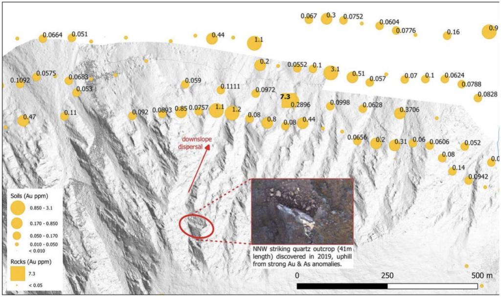
Figure 1: Gold concentrations in soil and talus fine samples, with the lone rock sample taken on the target to date, shown in parts per million (equivalent to grams per tonne). In 2019 a high-resolution photogrammetric drone survey revealed two dominant, repeated structural trends, one of which corresponds to the orientation of a large outcropping quartz vein uphill from multiple >1 g/t Au talus fine samples.
The Cliff property is situated within 13 kilometres of existing placer roads, 34 kilometres of a 30 MW hydroelectric station, and 40 kilometres of the town of Haines Junction, Yukon. For further information on Snowline’s Cliff, Einarson, and Rogue projects, please visit www.snowlinegold.com.
Qualified Person
The scientific and technical information contained in this news release has been reviewed and approved by Scott Berdahl, P. Geo., Chief Operating Officer of Snowline and a Qualified Person for the purpose of NI 43-101.