SUN DOG PROJECT
Map
Standard Uranium holds a 100%-interest in the 17,309-hectare Sun Dog project along the northwestern edge of the Athabasca Basin (Figure 1). The Sun Dog project is comprised of 6 contiguous mineral claims (Figure 2) located near Uranium City at the south end of the prolific Beaverlodge uranium district where uranium was mined between 1953 and 1982. Unlike the previously mined lower-grade Beaverlodge type deposits from this area, Standard’s exploration strategy at Sun Dog is targeting high-grade unconformity-related deposits that are typical of the Athabasca Basin, which would be a remarkable discovery in Canada’s original uranium mining district.


The three most promising historical target areas (Skye, Java, and Haven; Figure 3) were visited in Fall 2020 to confirm the location of historical exploration results and provide context for future work. Fall 2020 sampling efforts at the Skye, Java, and Haven target areas identified several zones of off-scale and visible uranium mineralization at surface (Photo 1 and Photo 2), and returned uranium assay results up to 3.58% U3O8, 1.7% U3O8, and 0.7% U3O8, respectively. Additionally, the analytical results reveal a correlation between uranium and gold mineralization, while boron and other pathfinder elements highlight the potential for a robust alteration footprint associated with uranium mineralization.


Fall 2020 exploration highlights include:
Skye Target Area
- Uranium mineralization was confirmed near the Stewart Island deposit at the Skye target, which is composed of three main uranium zones – The main, east, and west zones (Figure 4).
- 14 outcrop and boulder grab samples collected, 6 of which returned greater than 0.10% U3O8, and range between 0.95 ppm U and 3.58% U3O8.
- 3 of the 14 samples returned greater than 100 ppb gold with a high of 1.02 g/t Au.
- The confluence of EM conductors, resistivity-low, and interpreted faults remains the un-tested potential at the Skye Target area (Figure 4). The Company continues with the exploration model that the Stewart Island deposit mineralization could potentially be related to an unconformity-related uranium deposit located less than 1 km to the west.

Java Target Area – JSW-1 prospect
- 14 outcrop grab samples collected, 10 of which returned greater than 0.10% U3O8, and range between 0.07 ppm U and 1.7% U3O8.
- 8 of the 14 samples returned greater than 100 ppb gold with a high of 0.52 g/t Au.
- The convergence of EM conductors, underwater radiometric readings, resistivity-low and interpreted faults, associated with historically identified uranium in the strongly altered and brecciated, chlorite-, sulphide-, and graphite-bearing metasediments in the basement rocks below Athabasca Supergroup sandstones remains the primary target for follow-up exploration by the Company (Figure 5).
- Given the reconnaissance-scale drilling so far, the Company believes that the true potential of the Java target area has not yet been tested.

Haven Target Area
- Three prospects were visited, and 13 samples collected at the Haven Target area, including a previously undocumented prospect found by the Standard team.
- Of the 13 outcrop samples collected, 5 returned greater than 0.10% U3O8, and range between 136 ppm U and 0.70% U3O8.
- 3 of the 13 samples returned greater than 100 ppb of gold, with a high of 1.04 g/t Au.
- Located at the historical Walli Prospect (Figure 5), 2 of the 13 samples returned greater than 1,000 ppm boron. These results, coupled with the anomalous uranium of 0.10 and 0.13% U3O8 ~and elevated pathfinder elements such as lead, arsenic, copper, cobalt, and nickel suggest the identification of a robust alteration footprint within the Athabasca sandstones.
The target areas at the Sun Dog project have many attributes that are favourable for the formation of high-grade unconformity-related uranium mineralization. The key geological factors include uranium-enriched bedrock, reactivated and graphitized structures, Athabasca Supergroup sandstone cover, and favourable basement competency contrasts.
Photos
[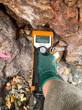
Photo 1. Off-scale (>65,535 CPS) uranium mineralization at surface in Athabasca sandstone](https://standarduranium.ca/site/assets/files/5705/sun_dog_photo_01.1024x0.jpg "Photo 1. Off-scale (>65,535 CPS) uranium mineralization at surface in Athabasca sandstone")
[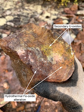
Photo 2. Athabasca sandstone hosting secondary uranium oxide/hydroxide mineralization with associated hydrothermal hematite](https://standarduranium.ca/site/assets/files/5705/sun_dog_photo_02.1024x0.jpg "Photo 2. Athabasca sandstone hosting secondary uranium oxide/hydroxide mineralization with associated hydrothermal hematite")
Maps & Figures
[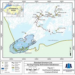
Figure 1: Northwest Athabasca Uranium District](https://standarduranium.ca/site/assets/files/5696/sun_dog_website_01.1024x0.jpg "Figure 1: Northwest Athabasca Uranium District")
[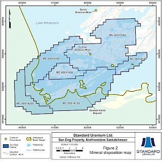
Figure 2: MIneral Disposition Map](https://standarduranium.ca/site/assets/files/5696/sun_dog_website_02.1024x0.jpg "Figure 2: MIneral Disposition Map")
[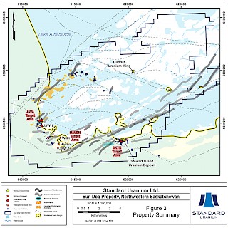
Figure 3: Property Summary](https://standarduranium.ca/site/assets/files/5696/sun_dog_website_03.1024x0.jpg "Figure 3: Property Summary")
[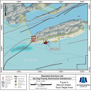
Figure 4: Stewart Island - Skye Target Area](https://standarduranium.ca/site/assets/files/5696/sun_dog_website_04.1024x0.jpg "Figure 4: Stewart Island - Skye Target Area")
[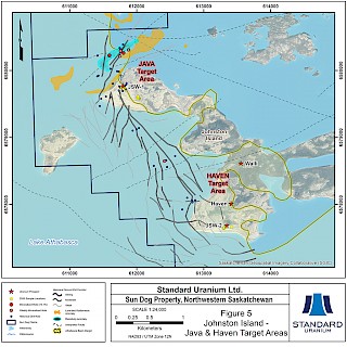
Figure 5: Johnston Island - Java & Haven Target Areas](https://standarduranium.ca/site/assets/files/5696/sun_dog_website_05.1024x0.jpg "Figure 5: Johnston Island - Java & Haven Target Areas")
Disclosure of Technical and Scientific Information
Except as otherwise noted herein, Neil McCallum, BSc. P.Geo., Standard Uranium’s VP Exploration, has reviewed and approved the scientific and technical information contained in this website. Mr. McCallum is a Qualified Person within the meaning of Canadian Securities Administrator’s National Instrument 43-101.