Dam
A dam is a barrier that stops or restricts the flow of surface water or underground streams. Reservoirs created by dams not only suppress floods but also provide water for activities such as irrigation, human consumption, industrial use, aquaculture, and navigability. Hydropower is often used in conjunction with dams to generate electricity. A dam can also be used to collect or store water which can be evenly distributed between locations. Dams generally serve the primary purpose of retaining water, while other structures such as floodgates or levees (also known as dikes) are used to manage or prevent water flow into specific land regions.
The word dam can be traced back to Middle English,[1] and before that, from Middle Dutch, as seen in the names of many old cities,[2] such as Amsterdam and Rotterdam.
Ancient dams were built in Mesopotamia and the Middle East for water control. The earliest known dam is the Jawa Dam in Jordan, dating to 3,000 BC. Egyptians also built dams, such as Sadd-el-Kafara Dam for flood control. In modern-day India, Dholavira had an intricate water-management system with 16 reservoirs and dams. The Great Dam of Marib in Yemen, built between 1750 and 1700 BC, was an engineering wonder, and Eflatun Pinar, a Hittite dam and spring temple in Turkey, dates to the 15th and 13th centuries BC. The Kallanai Dam in South India, built in the 2nd century AD, is one of the oldest water regulating structures still in use.
Roman engineers built dams with advanced techniques and materials, such as hydraulic mortar and Roman concrete, which allowed for larger structures. They introduced reservoir dams, arch-gravity dams, arch dams, buttress dams, and multiple arch buttress dams. In Iran, bridge dams were used for hydropower and water-raising mechanisms.
During the Middle Ages, dams were built in the Netherlands to regulate water levels and prevent sea intrusion. In the 19th century, large-scale arch dams were constructed around the British Empire, marking advances in dam engineering techniques. The era of large dams began with the construction of the Aswan Low Dam in Egypt in 1902. The Hoover Dam, a massive concrete arch-gravity dam, was built between 1931 and 1936 on the Colorado River. By 1997, there were an estimated 800,000 dams worldwide, with some 40,000 of them over 15 meters high.
History
Ancient dams
Early dam building took place in Mesopotamia and the Middle East. Dams were used to control water levels, for Mesopotamia's weather affected the Tigris and Euphrates Rivers.
The earliest known dam is the Jawa Dam in Jordan, 100 kilometres (62 mi) northeast of the capital Amman. This gravity dam featured an originally 9-metre-high (30 ft) and 1 m-wide (3.3 ft) stone wall, supported by a 50 m-wide (160 ft) earthen rampart. The structure is dated to 3000 BC.[3][4]
The Ancient Egyptian Sadd-el-Kafara Dam at Wadi Al-Garawi, about 25 km (16 mi) south of Cairo, was 102 m (335 ft) long at its base and 87 m (285 ft) wide. The structure was built around 2800[5] or 2600 BC[6] as a diversion dam for flood control, but was destroyed by heavy rain during construction or shortly afterwards.[5][6] During the Twelfth Dynasty in the 19th century BC, the Pharaohs Senosert III, Amenemhat III, and Amenemhat IV dug a canal 16 km (9.9 mi) long linking the Fayum Depression to the Nile in Middle Egypt. Two dams called Ha-Uar running east-west were built to retain water during the annual flood and then release it to surrounding lands. The lake called Mer-wer or Lake Moeris covered 1,700 km2 (660 sq mi) and is known today as Birket Qarun.[7]
By the mid-late third millennium BC, an intricate water-management system in Dholavira in modern-day India was built. The system included 16 reservoirs, dams and various channels for collecting water and storing it.[8]
One of the engineering wonders of the ancient world was the Great Dam of Marib in Yemen. Initiated sometime between 1750 and 1700 BC, it was made of packed earth – triangular in cross-section, 580 m (1,900 ft) in length and originally 4 m (13 ft) high – running between two groups of rocks on either side, to which it was linked by substantial stonework. Repairs were carried out during various periods, most importantly around 750 BC, and 250 years later the dam height was increased to 7 m (23 ft). After the end of the Kingdom of Saba, the dam fell under the control of the Ḥimyarites (c. 115 BC) who undertook further improvements, creating a structure 14 m (46 ft) high, with five spillways, two masonry-reinforced sluices, a settling pond, and a 1,000 m (3,300 ft) canal to a distribution tank. These works were not finished until 325 AD when the dam permitted the irrigation of 25,000 acres (100 km2).
Eflatun Pınar is a Hittite dam and spring temple near Konya, Turkey. It is thought to date from the Hittite empire between the 15th and 13th centuries BC.
The Kallanai is constructed of unhewn stone, over 300 m (980 ft) long, 4.5 m (15 ft) high and 20 m (66 ft) wide, across the main stream of the Kaveri River in Tamil Nadu, South India. The basic structure dates to the 2nd century AD[9] and is considered one of the oldest water diversion or water regulating structures still in use.[10] The purpose of the dam was to divert the waters of the Kaveri across the fertile delta region for irrigation via canals.[11]
Du Jiang Yan is the oldest surviving irrigation system in China that included a dam that directed waterflow. It was finished in 251 BC. A large earthen dam, made by Sunshu Ao, the prime minister of Chu (state), flooded a valley in modern-day northern Anhui Province that created an enormous irrigation reservoir (100 km (62 mi) in circumference), a reservoir that is still present today.[12]
Roman engineering
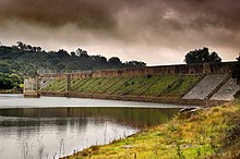 The Roman dam at Cornalvo in Spain has been in use for almost two millennia.
Roman dam construction was characterized by "the Romans' ability to plan and organize engineering construction on a grand scale."[13] Roman planners introduced the then-novel concept of large reservoir dams which could secure a permanent water supply for urban settlements over the dry season.[14] Their pioneering use of water-proof hydraulic mortar and particularly Roman concrete allowed for much larger dam structures than previously built,[13] such as the Lake Homs Dam, possibly the largest water barrier to that date,[15] and the Harbaqa Dam, both in Roman Syria. The highest Roman dam was the Subiaco Dam near Rome; its record height of 50 m (160 ft) remained unsurpassed until its accidental destruction in 1305.[16]
Roman engineers made routine use of ancient standard designs like embankment dams and masonry gravity dams.[17] Apart from that, they displayed a high degree of inventiveness, introducing most of the other basic dam designs which had been unknown until then. These include arch-gravity dams,[18] arch dams,[19] buttress dams[20] and multiple arch buttress dams,[21] all of which were known and employed by the 2nd century AD (see List of Roman dams). Roman workforces also were the first to build dam bridges, such as the Bridge of Valerian in Iran.[22]
 Remains of the Band-e Kaisar dam, built by the Romans in the 3rd century AD.
In Iran, bridge dams such as the Band-e Kaisar were used to provide hydropower through water wheels, which often powered water-raising mechanisms. One of the first was the Roman-built dam bridge in Dezful,[23] which could raise water 50 cubits (c. 23 m) to supply the town. Also diversion dams were known.[24] Milling dams were introduced which the Muslim engineers called the Pul-i-Bulaiti. The first was built at Shustar on the River Karun, Iran, and many of these were later built in other parts of the Islamic world.[24] Water was conducted from the back of the dam through a large pipe to drive a water wheel and watermill.[25] In the 10th century, Al-Muqaddasi described several dams in Persia. He reported that one in Ahwaz was more than 910 m (3,000 ft) long,[26] and that it had many water-wheels raising the water into aqueducts through which it flowed into reservoirs of the city.[27] Another one, the Band-i-Amir Dam, provided irrigation for 300 villages.[26]
Middle Ages
In the Netherlands, a low-lying country, dams were often built to block rivers to regulate the water level and to prevent the sea from entering the marshlands. Such dams often marked the beginning of a town or city because it was easy to cross the river at such a place, and often influenced Dutch place names. The present Dutch capital, Amsterdam (old name Amstelredam), started with a dam on the river Amstel in the late 12th century, and Rotterdam began with a dam on the river Rotte, a minor tributary of the Nieuwe Maas. The central square of Amsterdam, covering the original site of the 800-year-old dam, still carries the name Dam Square.
Industrial revolution
 An engraving of the Rideau Canal locks at Bytown.
The Romans were the first to build arch dams, where the reaction forces from the abutment stabilizes the structure from the external hydrostatic pressure, but it was only in the 19th century that the engineering skills and construction materials available were capable of building the first large-scale arch dams.
Three pioneering arch dams were built around the British Empire in the early 19th century. Henry Russel of the Royal Engineers oversaw the construction of the Mir Alam dam in 1804 to supply water to the city of Hyderabad (it is still in use today). It had a height of 12 m (39 ft) and consisted of 21 arches of variable span.[28]
In the 1820s and 30s, Lieutenant-Colonel John By supervised the construction of the Rideau Canal in Canada near modern-day Ottawa and built a series of curved masonry dams as part of the waterway system. In particular, the Jones Falls Dam, built by John Redpath, was completed in 1832 as the largest dam in North America and an engineering marvel. In order to keep the water in control during construction, two sluices, artificial channels for conducting water, were kept open in the dam. The first was near the base of the dam on its east side. A second sluice was put in on the west side of the dam, about 20 ft (6.1 m) above the base. To make the switch from the lower to upper sluice, the outlet of Sand Lake was blocked off.[29]
 Masonry arch wall, Parramatta, New South Wales, the first engineered dam built in Australia.
Hunts Creek near the city of Parramatta, Australia, was dammed in the 1850s, to cater to the demand for water from the growing population of the city. The masonry arch dam wall was designed by Lieutenant Percy Simpson who was influenced by the advances in dam engineering techniques made by the Royal Engineers in India. The dam cost £17,000 and was completed in 1856 as the first engineered dam built in Australia, and the second arch dam in the world built to mathematical specifications.[30]
The first such dam was opened two years earlier in France. It was the first French arch dam of the industrial era, and it was built by François Zola in the municipality of Aix-en-Provence to improve the supply of water after the 1832 cholera outbreak devastated the area. After royal approval was granted in 1844, the dam was constructed over the following decade. Its construction was carried out on the basis of the mathematical results of scientific stress analysis.
The 75-miles dam near Warwick, Australia, was possibly the world's first concrete arch dam. Designed by Henry Charles Stanley in 1880 with an overflow spillway and a special water outlet, it was eventually heightened to 10 m (33 ft).
In the latter half of the nineteenth century, significant advances in the scientific theory of masonry dam design were made. This transformed dam design from an art based on empirical methodology to a profession based on a rigorously applied scientific theoretical framework. This new emphasis was centered around the engineering faculties of universities in France and in the United Kingdom. William John Macquorn Rankine at the University of Glasgow pioneered the theoretical understanding of dam structures in his 1857 paper On the Stability of Loose Earth. Rankine theory provided a good understanding of the principles behind dam design.[31] In France, J. Augustin Tortene de Sazilly explained the mechanics of vertically faced masonry gravity dams, and Zola's dam was the first to be built on the basis of these principles.[32]
Modern era
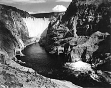 The Hoover Dam by Ansel Adams, 1942.
The era of large dams was initiated with the construction of the Aswan Low Dam in Egypt in 1902, a gravity masonry buttress dam on the Nile River. Following their 1882 invasion and occupation of Egypt, the British began construction in 1898. The project was designed by Sir William Willcocks and involved several eminent engineers of the time, including Sir Benjamin Baker and Sir John Aird, whose firm, John Aird & Co., was the main contractor.[33][34] Capital and financing were furnished by Ernest Cassel.[35] When initially constructed between 1899 and 1902, nothing of its scale had ever before been attempted;[36] on completion, it was the largest masonry dam in the world.[37]
The Hoover Dam is a massive concrete arch-gravity dam, constructed in the Black Canyon of the Colorado River, on the border between the US states of Arizona and Nevada between 1931 and 1936 during the Great Depression. In 1928, Congress authorized the project to build a dam that would control floods, provide irrigation water and produce hydroelectric power. The winning bid to build the dam was submitted by a consortium called Six Companies, Inc. Such a large concrete structure had never been built before, and some of the techniques were unproven. The torrid summer weather and the lack of facilities near the site also presented difficulties. Nevertheless, Six Companies turned over the dam to the federal government on 1 March 1936, more than two years ahead of schedule.[38]
By 1997, there were an estimated 800,000 dams worldwide, some 40,000 of them over 15 m (49 ft) high.[39] In 2014, scholars from the University of Oxford published a study of the cost of large dams – based on the largest existing dataset – documenting significant cost overruns for a majority of dams and questioning whether benefits typically offset costs for such dams.[40]
...
From Irrigation:
...Irrigation enabled the production of more crops, especially commodity crops in areas which otherwise could not support them. Countries frequently invested in irrigation to increase wheat, rice, or cotton production, often with the overarching goal of increasing self-sufficiency.[86] In the 20th century, global anxiety specifically about the American cotton monopoly fueled many empirical irrigation projects: Britain began developing irrigation in India, the Ottomans in Egypt, the French in Algeria, the Portuguese in Angola, the Germans in Togo, and Soviets in Central Asia.[87]
Negative impacts frequently accompanied extensive irrigation. Some projects which diverted surface water for irrigation dried up the water sources, which led to a more extreme regional climate.[88] Projects that relied on groundwater and pumped too much from underground aquifers created subsidence and salinization. Salinization of irrigation water in turn damaged the crops and seeped into drinking water.[89] Pests and pathogens also thrived in the irrigation canals or ponds full of still water, which created regional outbreaks of diseases like malaria and schistosomiasis.[90][91][92] Governments also used irrigation schemes to encourage migration, especially of more desirable populations into an area.[93][94][95] Additionally, some of these large nationwide schemes failed to pay off at all, costing more than any benefit gained from increased crop yields.[96][97]
American West
Irrigated land in the United States increased from 300,000 acres in 1880 to 4.1 million in 1890, then to 7.3 million in 1900.[42] Two thirds of this irrigation sources from groundwater or small ponds and reservoirs, while the other one third comes from large dams.[98] One of the main attractions of irrigation in the West was its increased dependability compared to rainfall-watered agriculture in the East. Proponents argued that farmers with a dependable water supply could more easily get loans from bankers interested in this more predictable farming model.[99] Most irrigation in the Great Plains region derived from underground aquifers. Euro-American farmers who colonized the region in the 19th century tried to grow the commodity crops that they were used to, like wheat, corn, and alfalfa, but rainfall stifled their growing capacity.
Between the late 1800s and the 1930s, farmers used wind-powered pumps to draw groundwater. These windpumps had limited power, but the development of gas-powered pumps in the mid-1930s pushed wells deep into the Ogallala Aquifer. Farmers irrigated fields by laying pipes across the field with sprinklers at intervals, a labor-intensive process, until the advent of the center-pivot sprinkler after WWII, which made irrigation significantly easier.[100] By the 1970s farmers drained the aquifer ten times faster than it could recharge, and by 1993 they had removed half of the accessible water.[101]
Large-scale federal funding and intervention pushed through the majority of irrigation projects in the West, especially in California, Colorado, Arizona, and Nevada. At first, plans to increase irrigated farmland, largely by giving land to farmers and asking them to find water, failed across the board. Congress passed the Desert Land Act in 1877 and the Carey Act in 1894, which only marginally increased irrigation.[102] Only in 1902 Congress passed the National Reclamation Act, which channeled money from the sale of western public lands, in parcels up to 160 acres large, into irrigation projects on public or private land in the arid West.[103] The Congressmen who passed the law, as well as their wealthy supporters, supported Western irrigation because it would increase American exports, ‘reclaim’ the West, and push the Eastern poor out West in search of a better life.[104]
While the National Reclamation Act was the most successful piece of federal irrigation legislation, the implementation of the act did not go as planned. Originally, the Reclamation Service planned to construct a small number of projects that would allow engineers to learn from the process, but President Roosevelt chose instead push as many irrigation projects through as fast as possible. The Reclamation Service also chose to push most of the Act’s money toward construction rather than settlement, so the Service overwhelmingly prioritized building large dams like the Hoover Dam.[105]
Over the 20th century Congress and state governments grew more frustrated with the Reclamation Service and the irrigation schemes in general. Frederick Newell, head of the Reclamation Service, proving uncompromising and difficult to work with, falling crop prices, resistance to delay debt payments, and refusal to begin new projects until the completion of old ones all contributed.[106] The Reclamation Extension Act of 1914, transferring a significant amount of irrigation decision-making power regarding irrigation projects from the Reclamation Service to Congress, was in many ways a result of an increasing political unpopularity of the Reclamation Service.[107]
In the lower Colorado Basin of Arizona, Colorado, and Nevada, the states derive irrigation water largely from rivers, especially the Colorado River, which irrigates more than 4.5 million acres of land, with a less significant amount coming from groundwater.[108] In the 1952 case Arizona v. California, Arizona sued California for increased access to the Colorado, under the grounds that their groundwater supply could not sustain their almost entirely irrigation-based agricultural economy, which they won.[109] California, which began irrigating in earnest in the 1870s in San Joaquin Valley,[110] had passed the Wright Act of 1887 permitting agricultural communities to construct and operate needed irrigation works.[111] The Colorado also irrigates large fields in California’s Imperial Valley, fed by the National Reclamation Act-built All-American Canal.[112][113]
Soviet Central Asia
When the Bolsheviks conquered Central Asia in 1917, the native Kazakhs, Uzbeks, and Turkmens used minimal irrigation. The Slavic immigrants pushed into the area by the Tsarist government[114] brought their own irrigation methods, including waterwheels, the use of rice paddies to restore salted land, and underground irrigation channels. Russians dismissed these techniques as crude and inefficient. Despite this, in absence of other solutions, tsarist officials maintained these systems through the late 19th century.[115]
Before conquering the area, the Russian government accepted a 1911 American proposal to send hydraulic experts to Central Asia to investigate the potential for large-scale irrigation. A 1918 decree by Lenin then encouraged irrigation development in the region, and development began in the 1930s. When it did, Stalin and other Soviet leaders prioritized large-scale, ambitious hydraulic projects, especially along the Volga River. The Soviet irrigation push stemmed largely from their late 19th century fears of the American cotton monopoly and subsequent desire to achieve cotton self-sufficiency.[116] They had built up their textile manufacturing industry in the 19th century, requiring increased cotton and irrigation, as the region did not receive enough rainfall to support cotton farming.[115]
The Russians built dams on the Don and Kuban Rivers for irrigation, removing freshwater flow from the Sea of Azov and making it much saltier. Depletion and salinization scourged other areas of the Russian irrigation project. In the 1950s Soviet officials began also diverting the Syr Darya and the Amu Darya, which fed the Aral Sea. Before diversion, the rivers delivered 55km3 of water to the Aral Sea per year, but after they only delivered 6km3 to the Sea. Because of its reduced inflow, the Aral Sea covered less than half of its original seabed, which made the regional climate more extreme and created airborne salinization, lowering nearby crop yields.[117]
By 1975, the USSR used eight times as much water as they had in 1913, mostly for irrigation. Russia’s expansion of irrigation began to decrease in the late 1980s, and irrigated hectares in Central Asia capped out at 7 million. Mikhail Gorbachev killed a proposed plan to reverse the Ob and Yenisei for irrigation in 1986, and the breakup of the USSR in 1991 ended Russian investment in Central Asian cotton irrigation.[118]
Africa
Different irrigation schemes with a variety of goals and success rates have been implemented across Africa in the 20th century, but have all been influenced by colonial forces. The Tana River Irrigation Scheme in eastern Kenya, completed between 1948 and 1963, opened up new lands for agriculture, and the Kenyan government attempted to resettle the area with detainees from the Mau Mau uprising.[119] Libya’s underground water resources were discovered by Italian oil drillers during the Italian colonization of Libya. This water lay dormant until 1969, when Muammar al-Gaddafi and American Armand Hammer built the Great Man-Made River to deliver the Saharan water to the coast. The water largely contributed to irrigation but cost four to ten times more than the crops it produced were worth.[120]
In 1912, the Union of South Africa created an irrigation department and began investing in water storage infrastructure and irrigation. The government used irrigation and dam-building to further social goals like poverty relief, both by creating construction jobs for poor whites and by creating irrigation schemes to increase white farming. One of their first major irrigation projects was the Hartbeespoort Dam, begun in 1916 as a mechanism to elevate the living conditions of the ‘poor whites’ in the region and eventually completed as a ‘whites only’ employment opportunity.[121] The Pretoria irrigation scheme, Kammanassie project, and Buchuberg irrigation scheme on the Orange River all followed in the same vein in the 1920s and 30s.[39]
In Egypt, modern irrigation began with Muhammad Ali Pasha in the mid-1800s, who sought to achieve Egyptian independence from the Ottomans through increased trade with Europe—specifically cotton exportation.[122] His administration proposed replacing the traditional Nile basin irrigation, which took advantage of the annual ebb and flow of the Nile, with irrigation barrages in the lower Nile which better suited cotton production. Egypt devoted 105,000 ha to cotton in 1861, which increased fivefold by 1865.
The majority of their exports were shipped to England, and the United-States-Civil-War-induced cotton scarcity in the 1860s cemented Egypt as England’s cotton producer.[123] As the Egyptian economy became more dependent on cotton in the 20th century, it became more important to control even small Nile floods. Cotton production was more at risk of destruction than more common crops like barley or wheat.[124] After the British occupation of Egypt in 1882, the British intensified the conversion to perennial irrigation with the construction of the Delta Barrage, the Assiut Barrage, and the first Aswan Dam. Perennial irrigation decreased local control over water and made traditional subsistence farming or the farming of other crops incredibly difficult, eventually contributing to widespread peasant bankruptcy and the 1879-1882 ‘Urabi revolt.[125]
...