DONJEK PROPERTY
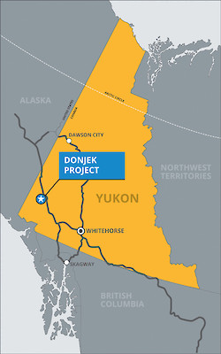
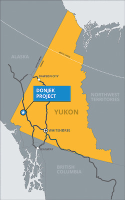 The Donjek Property is located approximately 15km south of the Donjek River Bridge on the Alaska Highway, 125km northwest of the village of Haines Junction, and 285 km northwest of Whitehorse, Yukon Territory. The Property is situated in the Whitehorse Mining District, and access is currently by helicopter from a staging area located within 15km of the Property at the Donjek River Bridge on the Alaska Highway.

The Donjek property consists of a contiguous block of 169 quartz claims 100% owned by Victoria Gold Corp. covering an area of approximately 3,500 hectares.
- ####


- The Donjek Project partly covers the Sexsmith drilled prospect (MINFILE# 115G 033), a MINFILE occurrence as documented by the Yukon Geological Survey (Deklerk, 2009). In 1953 the area was staked by Canalask Nickel Mines Ltd. to cover an aeromagnetic anomaly, discovered by Lundberg Exploration Ltd. during a regional survey following the discovery of the Wellgreen Deposit, and explored with ground magnetic and self-potential surveys. The anomaly, situated in an overburden covered area north of Wolverine Creek near its confluence with the Donjek River, returned zones of anomalous self-potential and was subsequently drilled, however no report on these activities was ever filed with the Yukon Government. Old core at the showing reportedly consists of fine grained siltstone (Davidson, 1988) and/or ultramafic rock (Duncan and Tupper, 2002a&b) containing disseminated chalcopyrite.
The area was re-staked in 1973 by the Nickel Syndicate (Canadian Superior Exploration Ltd., Aquitaine, Home Oil Ltd. and Getty Minerals Ltd.) (Deklerk,2009). Ground-based geophysics by Harjay Exploration Ltd. in 1988 identified a northwest-trending VLF-EM anomaly coincident with the west edge of a strong magnetic high which appears to outline a contact (Davidson, 1988).
An airborne electromagnetic/resistivity/magnetic survey was completed in 1996 by Dighem for Expatriate Resources Ltd. (Chung, 1997), followed by mapping, prospecting, soil and stream sediment sampling by the Donjek Joint Venture (Expatriate and Strategic Metals Ltd.) (Duncan and Tupper, 2002a&b). This geophysical survey delineated a strong magnetic high and several moderately weak or broad conductors, and the mapping outlined pyritic mafic and ultramafic rocks, including peridotite, gabbro, diorite and andesite flows.
The claims were optioned to Midnight Mines Ltd. (Bill Harris) in 2002 and subsequently transferred to StrataGold Corporation as part of a reorganization of Expatriate Resources, with the Midnight Mines Ltd. option retained (Deklerk, 2009).
In 2004, re-interpretation of 1965-6 Geological Survey of Canada total magnetic field data by Aurora Geosciences Ltd. identified a large magnetic anomaly interpreted as an ultramafic source (Power, 2004).
In 2011, a total of 5-man days were spent on the Donjek Project consisting of mapping and prospecting with concurrent rock geochemical sampling.
In 2015, an aeromagnetic survey was conducted over the area by a Yukon Geologic Survey and Kluane First Nations partnership with survey oversight and data processing as part of the Geo-mapping for Energy and Minerals Program of Natural Resources Canada.
- ####