BLOCK 4
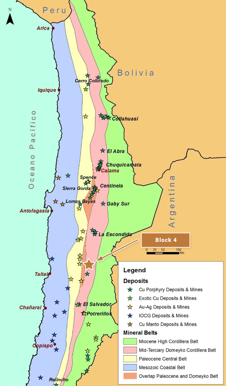
Block 4 is located in northern Chile and is centered approximately 220 km south-southeast of the coastal port city of Antofagasta. The property is situated along one of the most geologically productive segments of the Andean Cordillera, along trend and approximately 110 km south of the giant La Escondida copper mine and other related copper deposits in the district (BHP Billiton, Rio Tinto, Antofagasta Minerals and Barrick Gold). The reader is cautioned that there is no evidence to date that a comparable mineral resource could be found at Block 4.
OWNERSHIP
The Block 4 project area consists of approximately 4,200 Ha of 100% owned tenement comprising both exploration and mining concessions.
The property is subject to an underlying 1% NSR Royalty on production of all metals.
GEOLOGY AND DEPOSIT TYPE
Block 4 lies along the mid-Tertiary porphyry copper belt of northern Chile – the Domeyko Cordillera – that is host to three of the world’s top five copper mining districts at Collahuasi, Chuquicamata and La Escondida (the world’s single largest copper mine).
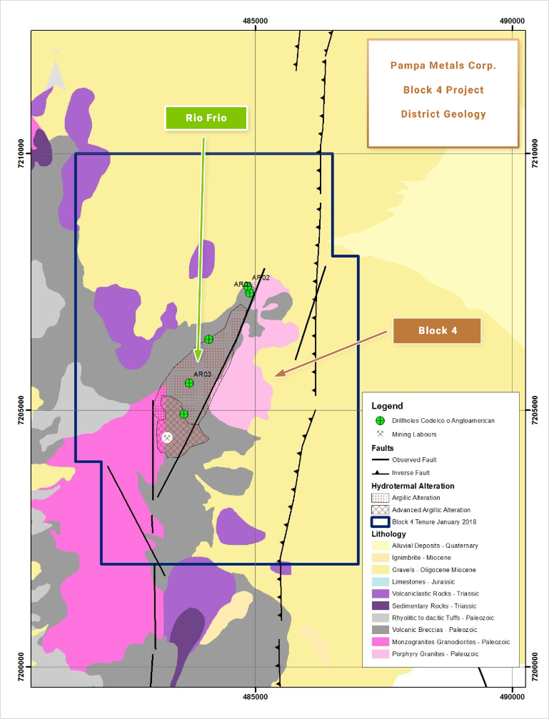
Significant portions of the Block 4 property are characterised by post-mineral Miocene to Recent alluvial and volcanic cover, particularly to the north and east within the property, where the underlying geology is obscured. Elevated sierras expose Palaeozoic intrusions, Late Triassic to Jurassic sedimentary sequences, and Jurassic limestones, particularly at the southwest portions of Block 4. These basement rocks are cut by early Tertiary (~ 65 Ma) intrusions to the southeast of Block 4.
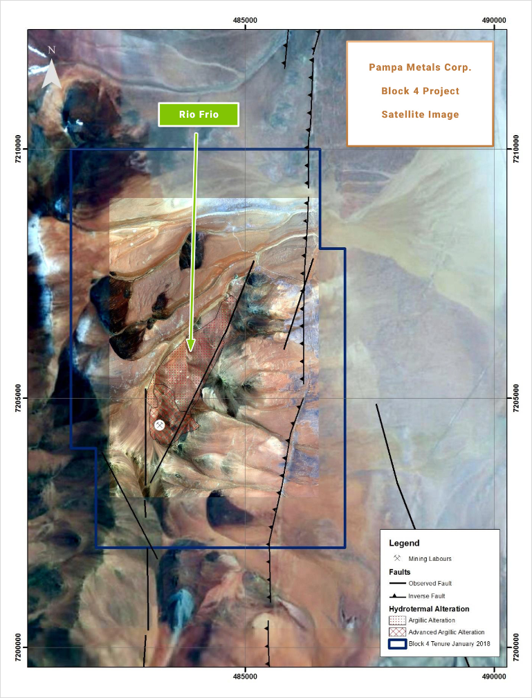
Block 4 contains a partially outcropping porphyry-style target zone at Rio Frio, characterized by a quartz-eye porphyry intrusion, argillic to sericitic hydrothermal alteration assemblages, and weak quartz veinlets, over an area of 2 km x 4 km. NE-trending structures linked in to the principal Domeyko Cordillera faults occur.
EXPLORATION AND RESULTS TO DATE
The Rio Frio alteration zone has porphyry copper characteristics and is associated with a dacitic quartz-eye porphyry intrusion displaying argillic alteration, quartz-sericite alteration and silicification, together with relict chalcopyrite and pyrite boxworks in the leached surficial outcrops. Copper oxides also occur, including in a historic trench extending off into a post-mineral covered area to the northeast.
BHP previously completed reconnaissance scale geological mapping over the property, supplemented by limited geochemical sampling. The Rio Frio target, and possible extensions under post-mineral cover, were not evaluated in detail, although further work was recommended. Minor historic drill testing (provenance and results unknown – possibly from the 1990s) has been carried out at Rio Frio. No recent drilling has been carried out anywhere on the property.
Both the Rio Frio target and extensions under cover to the east and north warrant further exploration.
INFRASTRUCTURE
Access to the property is via a variety of moderate quality dirt roads leading off from the Pan-American Highway to the west, and other access points. Total journey time from Antofagasta is about 5 hours, and from Taltal about 4 hours. Altitudes vary from approximately 3,400 m in the post-mineral covered portions of the property, to around 4,500 m in the sierras.
QUALIFIED PERSON
Mario
Orrego G, Geologist, MBA and Qualified Person of the Mining Commission of Chile, an independent consultant, is the Company’s Qualified Person for the purposes of National Instrument 43 101 Standards of Disclosures for Mineral Projects of the Canadian Securities Administrators, and is responsible for the accuracy of, and has verified the technical information in, this project summary, and has approved its written disclosure.
BLOCK 4 SUMMARY KEY POINTS
LOCATION
Northern Chile, 220 km SSE of Antofagasta
Centred 110 km S of the giant La Escondida Mining District (BHP Billiton Rio Tinto Other)
OWNERSHIP
100% Pampa Metals
PROPERTY SIZE
~ 4,200 Ha
DEPOSIT TYPE
Porphyry Copper (+/- Au +/- Mo)
STAGE
Early stage, partially outcropping porphyry target with post mineral gravel covered (
extensions limited historic drilling (unknown provenance)
EXPLORATION PLANS
Geophysical surveying 3 D Vector IP Resistivity with combined Magneto Telluric measurements,
and improved Ground Magnetics Surveys)
Drill Testing of best anomalies
INFRASTRUCTURE
Moderate access dirt roads from Pan American Highway 75 km to the west
Altitudes ranging from approximately 3 400 m to 4 500 m