FISHER PROJECT JV
The 33,171 ha Fisher Property is located 135 km ENE of La Ronge, Saskatchewan and is centred 2 km south of the Seabee Gold Operation's Santoy Mine, owned and operated by SSR Mining (formerly Silver Standard Resources). The claims are accessible by an all season road from the nearby Seabee Gold Operation for the deployment of heavy equipment and exploration crews. The property is also accessible by air from Missinipe/Otter Lake, a road accessible town located 100 km west of the property.
Project Highlights
- Numerous high-grade gold discoveries made through drilling along the Santoy Shear structure
- Widespread and continuous high-grade gold mineralization discovered by drilling at the Mac North Zone
- Adjacent to the producing Santoy Mine
- Multiple untested geophysical/geochemical anomalies associated with favourable geology
- Operated by the Fisher JV (an 80/20% jv between SSR Mining and Taiga Gold)
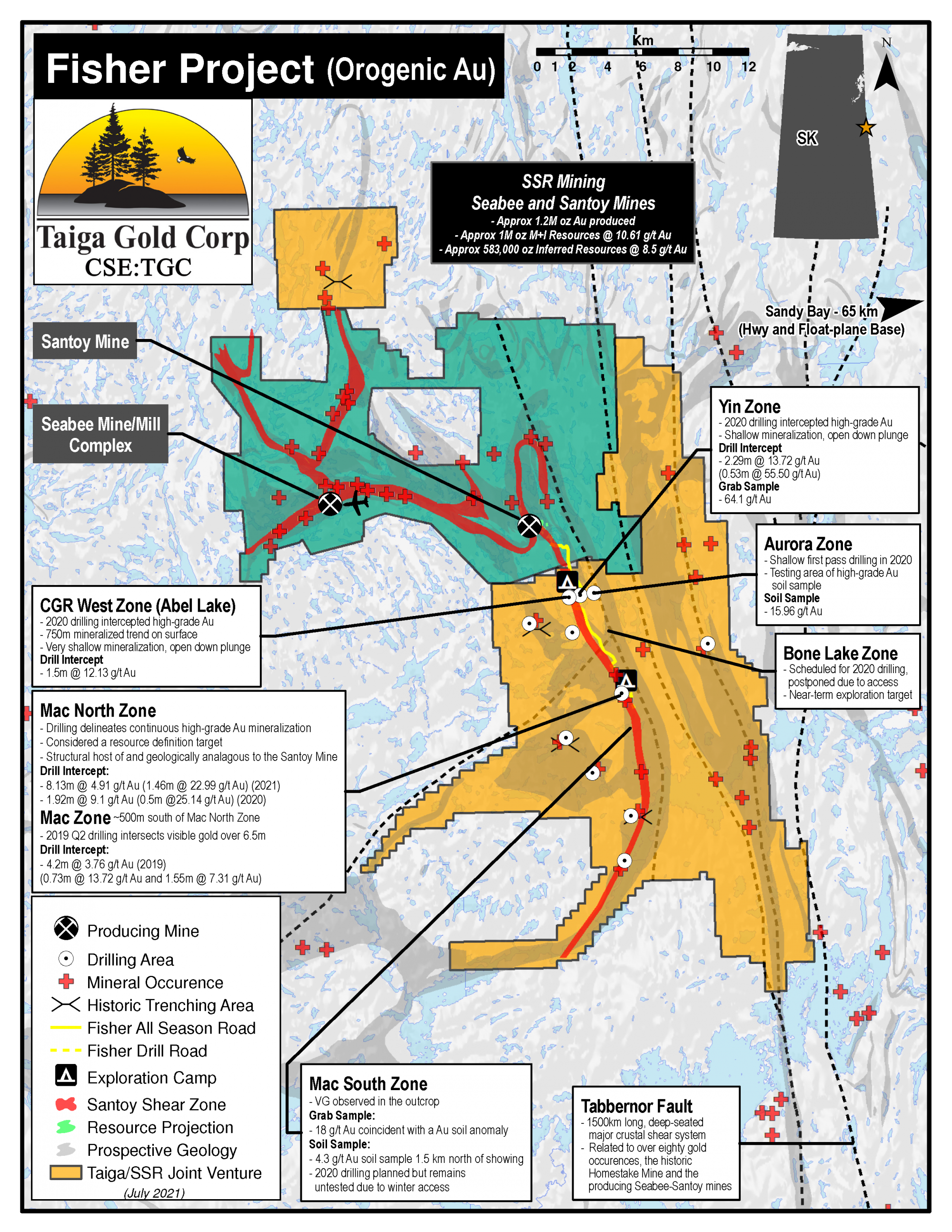
 Fisher Project Map - Printable PDF
Geology
The Fisher Property is located within metavolcanic, metagabbroic, epiclastic and metagreywacke units of the Glennie Domain and in the hanging-wall block of the north-south trending Tabbernor Lake fault system – a major crustal shear system transecting the Trans Hudson Orogen, that has been traced over 1500 km from the Wollaston Lake area of northern Saskatchewan to within 100 km of the Black Hills in South Dakota. Splays of the Tabbernor Lake fault system in the Laonil Lake region contain shear hosted quartz-tourmaline-pyrite-pyrrhotite-gold mineralized veins which typify ore-hosting structures at the Seabee Mine. The Seabee Gold Mine, purchased by SSR MIning from Claude Resources Inc. in March 2016, has been in operation since 1991 producing a total of 1 million ounces as of Aug, 2012 at an average grade of 0.23 oz/ton Au (7.89 g/t).
In light of the structural setting (proximity to the major crustal Tabbernor Fault) and style of mineralization in relation to this structure (gold associated with quartz veins and shearing with carbonate, chlorite and potassic alteration), the Fisher Property fits well into an Orogenic Gold deposit model with a greenstone host.
History
The Fisher is a very large property and for detailed discussion is divided into six zones which can be found under the “project details” tab. Below is a general outline of the exploration history highlights on the property as a whole.
Much of the property area has been mapped at varying scales by the Geological Survey of Canada and the Saskatchewan Geological Survey between 1956 and 1992.
As early as 1956, regional-scale geophysical surveys were being conducted over much of the greater property area and ground-based reconnaissance efforts were discovering and sampling gold mineral showings.
In 1984, because the Seabee Mine mineralization is a time-rock analogue of the rocks within the greater Fisher Property area, Claude Resources acquired ground directly south of the Seabee Mine and began systematic exploration and were the first to note gold mineralization in the George Lake area. Prospecting, geological mapping, soil geochemistry and ground-based geophysical surveys identified numerous targets some of which were trenched and drilled between this time and 1991 with encouraging results. Despite this, not much work was carried out on the property until 2007 when an airborne geophysical survey was flown, this was the last work carried out prior to Eagle Plains acquisition.
Eagle Plains Exploration - Pre Spin-out of Taiga Gold Corp.
Eagle Plains staked in the Kettle Falls area in 2012, recognizing the gold potential in the Seabee Camp and associated Tabbernor Fault system which transects the current property.
Field work in 2013 and 2014 included prospecting, regional mapping, soil geochemical surveying and channel rock sampling at the newly discovered WTF (Fisher) Showing. Gold results were very encouraging. Samples from north and south of the falls and follow-up channel sampling of the WTF showing returned highly anomalous gold and silver results.
Encouraged by this, Eagle Plains staked additional tenure on-strike and conducted follow-up fieldwork in 2015. A second mineralized outcrop similar to the WTF was located along strike 170 m to the NE. Moss pulling exposed up to 8 m of strongly altered volcanics and channel samples over this zone returned anomalous base- and precious-metals values.
Acquisition of the greater Fisher Property area was completed in Q1 2016.
An exploration program in 2016 consisted of three components and was ultimately funded by option partner SSR Mining:
- Acquisition and compilation of satellite airphoto orthoimagery over the entire property to assist ground-based programs.
- A 2 phase ground-based field-program conducted over several areas of the property.
- An airborne geophysical survey flown over the majority of the property area.
With the compiled airphoto orthoimagery in hand exploration crews initiated a ground-based program of prospecting, mapping, soil geochemical sampling, till sampling and geophysical surveying. A second phase of ground work followed-up the results of the airborne geophysical survey and the phase I field work by conducting prospecting, mapping, infill till sampling, soil geochemical sampling and channel rock sampling of the best new targets.
2016 Exploration highlights include:
The key finding for 2016 is a new subtle gossanous mineralized zone 450 m SW of the Fisher (WTF) Showing. Coined ‘The Big Smoke’, this area hosts at least 3 north trending shear zones with chip samples returning up to 2.6 g/t Au. A third narrow NNE-trending high-grade anomaly coined the ‘Lightening Strike’ traced over a strike of at least 425 m was also located. Soil results and anomalous grab samples extend the known mineralized strike-length of the Fisher Showing to over 1100m.
Another discovery was made of two new showings, the BC Trench and King Fisher in the Georges Lake area. The BC-Trench returned up to 143 g/t Au in grab samples and 30.1 g/t Au over a 30 cm chip sample in a distinct shear zone within the Seal Lake granite. The second new King Fisher Showing was discovered adjacent to a gold-in-soil anomaly, and returned up to 1.4 g/t Au in grab samples.
At Footprint Lake follow-up prospecting led to discovery of a new vein system with grab sample result of up to 19.4 g/t Au.
Till sampling has successfully delineated a promising well-constrained target for future focused exploration close to the southern boundary of SSR Mining's Seabee Gold Mine Property and their Santoy deposits.
Future Work
Recommended exploration work prior to SSR Mining optioning the Fisher project in 2016 included follow-up prospecting, mapping, trenching, infill and extension soil geochemical surveying, induced polarization geophysics and diamond drilling as a result of the discoveries made during 2016 and earlier programs. This work was recommended in the Georges Lake, Footprint Lake, Eisler Lake and Kettle Falls areas of the property.
SSR Mining Exploration
Once SSR Mining had optioned the Fisher Project in Q3 of 2016 it directed the exploration programming. In 2017, SSR Mining's ground-based exploration efforts identified an extension of the Santoy Shear Zone on the Fisher project. This shear zone hosts the Santoy Mine and the extension of it is mapped from the Fisher's northern boundary located approximately 1.5km south of the Santoy Mine and for 7km to the south, it remains open along strike. A map identifying this shear zone can be viewed under the "Highlights" tab above.
In early 2018, SSR Mining commenced a drill program focused on the extension of the Santoy Shear Zone, this was followed by another drill program in early 2019 and a large ground-based program of prosecting, mapping and soil sampling in that summer. As a result, the Santoy Shear Zone is now interpreted to extend up to 25km, bisecting the entire Fisher project. Extensive ground-based exploration along the northern portion of the Santoy Shear within the the Fisher property has identified a 13km high-grade gold trend from the border with Seabee Gold Operation and south along the shear, the remainder of this structure to the south remains relatively untested. The 2019 programs located numerous new high-grade gold occurrences over this 13km trend and identified a highly prospective area between the Mac Zone and a cluster of high-grade samples located 500m to the north. Structural interpretation indicates the geological setting of the Mac North to be analagous to the high-grade zones at the nearby Santoy Mine Complex. Other new target areas were identified near the border with the Santoy Mine.
In late 2019 the exploration camp located in the Fisher property was doubled in capacity to accommodate a larger crew for the planned 2020 drill program. A 9,463m drill program was conducted in Q1 2020 testing 4 zones, Yin, Abel Lake, Mac North and Aurora. High-grade gold mineralization was discovered at 3 of the 4 zones tested, see Fisher Project map for details. This drill program was curtailed slightly due to the COVID19 crisis and no ground-based summer program was conducted as a result. In late Q3 2020, a 3800m drill program commenced at the Mac North zone to follow up the discovery there with results expected to be issued in early 2021.
On November 12, 2020 SSR Mining notified Taiga Gold Corp. that that it has satisfied its earn-in commitments and exercised the First Option earn-in relating to the Fisher Option Agreement, earning a 60% interest.
On January 5, 2021 SSR Mining notified Taiga Gold Corp. that it has exercised the Second Option earn-in relating to the Fisher Option Agreement, for a total interest of 80% in the Fisher Property. As a result, an 80/20% joint-venture has been formed between SSR Mining and Taiga Gold Corp. called the "Fisher JV". In order to execise this second option SSR Mining has paid Taiga Gold $3 million cash.
In February 2021 Taiga Gold announced the results of the field work conducted at the Fisher by partner SSR Mining during 2020. As mentioned, early 2020 drilling resulted in the discovery of high-grade gold in three separate zones, the Yin, Abel Lake and Mac North, this is in addition to the original discovery of high-grade gold at the Mac Zone in 2019. In Q4 2020 a 3570m drill program in six holes was carried out at the Mac North Zone. The results of this 6 holes program was the identification of consistent and continuous high-grade gold at the Mac North over an area of 250m strike length x 600m down plunge. This area is now planned for further drill testing targeting resource definition. To this time SSR Mining has spent in excess of $12m in exploration and has made cash payments of $3.8m to Taiga Gold Corp. and predecessor Eagle Plains. Going forward the Fisher property will be operated by the 80/20% Fisher JV and exploration programs will be funded 80% SSR Mining and 20% Taiga Gold Corp.
In July 2021 the Fisher JV announced the results of an 1156m drill program that had been carried out in Q1 2021 at the Mac North Zone. Drilling encountered gold mineralization in all four holes with three reporting significant intercepts and one hole returning the highest gold values reported to date at the Fisher. This program continues to confirm the presence of continuous and consistent gold mineralization at the Mac North Zone over an area of 250m strike length x 600m down plunge. Results are pending for a 2835m, 7 hole drill program that was carried out in Q2 2021 targeting the Mac (2 holes), Mac North Hangingwall (2 holes), and previously untested Jasmine Zones (3 holes).
Updated July 15, 2021