CHICO PROPERTY
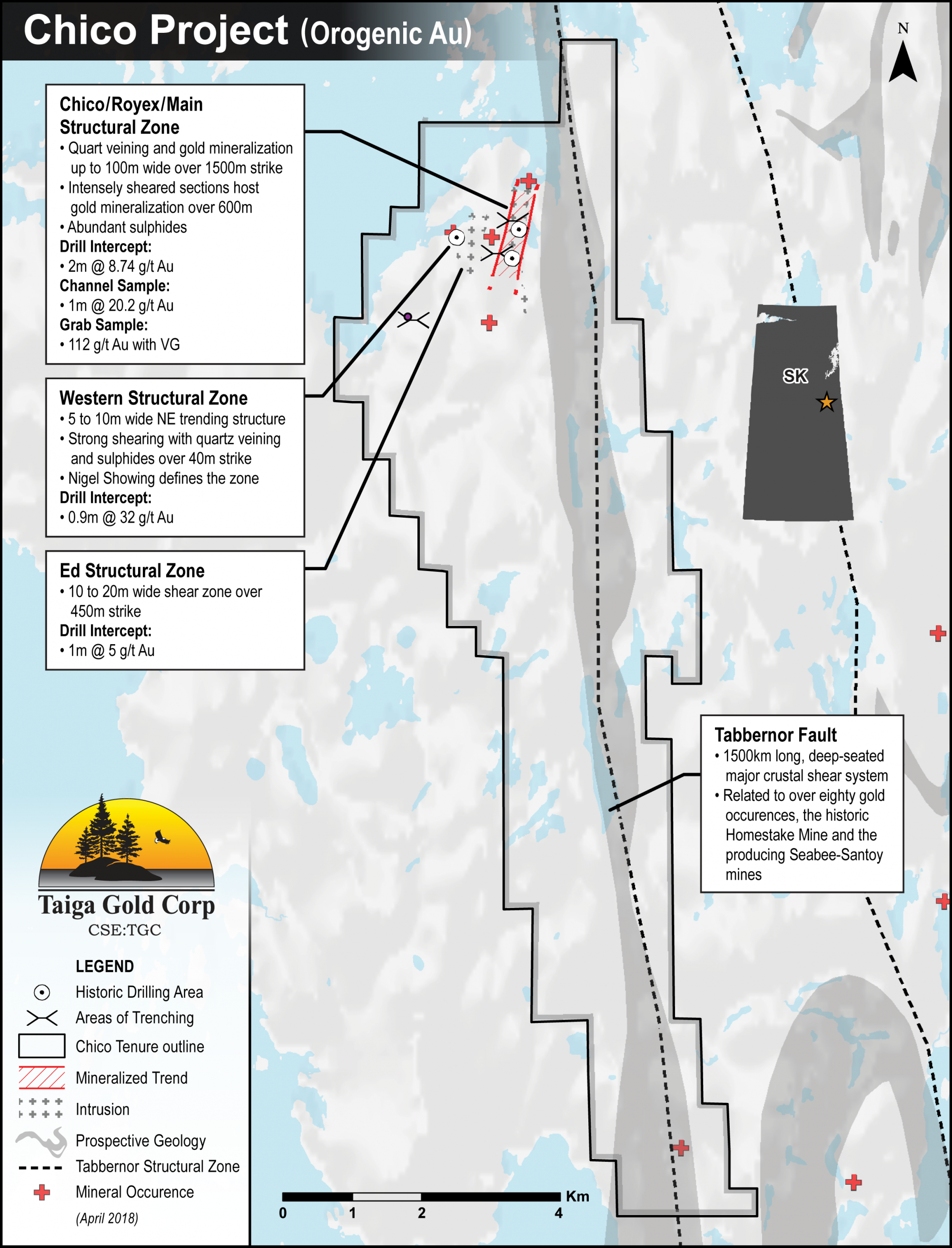
The 4656ha Chico Property is a highly prospective precious-metal exploration project. The core claims were acquired in 2015 with additional claims added in 2016. The property lies 45 km SE of SSR Mining’s Seabee Gold Operation and 105km NW of Flin Flon, MB. It is accessible by fixed wing aircraft and winter road from the village of Pelican Narrows located 25km SE which in turn is serviced by an airport, Hwy 135 - an all-weather road and a hydro power grid.
Project Highlights
- Excellent geology favourable for gold deposits
- Significantly underexplored with encouraging early results
- On-trend with the currently producing Seabee Mine
- Multiple Au showings associated with favourable geology
- Numerous high-grade Au showings focused along a major structure
 Chico Gold Project Map - Printable PDF
Geology
Mineralization on the property is hosted by felsic to intermediate intrusive rocks, cut by a series of NE trending brittle-ductile shear zones that splay from the Tabbernor Fault. The gold mineralisation is intimately associated with quartz veining and/or associated sulphides (pyrite, pyrrhotite, chalcopyrite), as well as within sulphide bearing dykes. These veins and dykes are commonly associated with zones of dilatancy that occur within the structures.
The main deposit type being explored for is structurally-controlled mesothermal lode gold. These deposits are hosted by brittle, brittle-ductile, and ductile, moderately to steeply-dipping second and third order deformation zones associated with regional scale faults such as the Tabbernor fault. The nearest analogue would be the currently producing Seabee Gold Operation with approximately 1.2M oz of gold production. Although it was not strictly a mesothermal lode gold deposit, it should be noted that the Homestake Gold Deposit in South Dakota (>40M oz Au production), is also situated within the southern Trans-Hudson to the west of where the Tabbernor Fault terminates.
History
In 1932 the GSC conducted regional mapping of the area and district scale mapping occurred in 1957 and 1976 conducted by the Sask. Dept. of Mineral Resources.
Starting in 1971, industry began exploring the region with airborne geophysical programs identifying several excellent N-NE trending conductors east of Manawan Lake.
Between 1987 and 2010, multiple exploration projects were carried out on the property which included geological mapping, prospecting, soil sampling, geophysics and diamond drilling. Each successive program resulted in discoveries of new showings and gold mineralization. Ultimately, these programs identified three main areas of interest, the Western, Chico/Royex and Ed structural zones.
Conclusions from the last exploration conducted prior to Eagle Plains’ acquisition were that detailed prospecting on the property continues to make new discoveries. As has been the case in previous programs, the best mineralization is focussed on sulphide rich shear zones with a NE orientation. Recommendations were that prospecting and geological mapping can be carried out as a matter of course, but more advanced exploration techniques are justified. These included a detailed airborne geophysical survey over the property and surrounding area in light of looking at potential structural elements that would yield high quality drill targets.
Chico Project Zones
To date, three N-NE trending mineralized structural zones have been identified on the property. The most significant being the Chico/Royex or Main Quartz Swarm. This is an impressive looking structure with abundant sulphides, quartz veining and gold mineralization up to 100 m wide and has been traced over a strike length of 1,500 m. Significant gold mineralization associated with a structure of this magnitude, is very encouraging. The potential for discovering economic gold mineralization along this structure remains promising.
Eagle Plains Exploration - Pre-Spin-Out into Taiga Gold Corp.
A comprehensive data compilation of historic work was conducted in the summer of 2016. This work was followed by a ground-based exploration program and an airborne geophysical survey. This work guided an I.P. geophysical survey in 2017 which determined the responses associated with known surface gold mineralization at the Chico/Royex and Western structural trends. These were used to refine future drill targets. Results of this work revealed in general that known surface mineral showings tend to have relatively small IP anomaly signatures with chimney-like geometries that appear to expand in size and strength with depth and that mineralization potentially increases below depths of 75 to 125m vertical.
Future Work
Based on the interpretation of the work to date it is recommended that a 1200 - 1600m drill program be carried out to test the sub-vertical projections of known surface geochemical and geological targets at, or below depths of 125m, into elevated zones of chargeability.
Updated May 25, 2020