CERRO BLANCO COPPER GOLD PROJECT
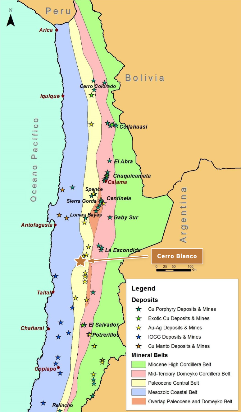
Cerro Blanco is located in northern Chile approximately 130 km southeast of the coastal port city of Antofagasta, and in a similar geological setting to, and approximately 200 km south-southwest of, the Spence (BHP) and Sierra Gorda (KGHM & Sumitomo) copper mines, and close to and along trend from both the El Peñon and Guanaco gold-silver mines. The reader is cautioned that there is no evidence to date that a comparable mineral resource could be found at Cerro Blanco.
OWNERSHIP
The Cerro Blanco project area consists of approximately 6,500 Ha of 100% owned tenement comprising both exploration and mining concessions.
The property is subject to an underlying 2% NSR Royalty on production of all metals.
GEOLOGY AND DEPOSIT TYPE
Cerro Blanco lies within the Paleocene volcanic belt of northern Chile that hosts a series of important porphyry copper deposits and mines, such as Cerro Colorado (BHP), Spence (BHP), Sierra Gorda (KGHM & Sumitomo) and Relincho (part of Nueva Union – Teck¬Goldcorp).
The property is also situated along trend and approximately 23 km to the southwest of the important El Peñon and Fortuna mines (Yamana Gold), which exploit a series of high-grade, low-sulphidation, epithermal gold and silver veins associated with the Dominador Fault Zone.
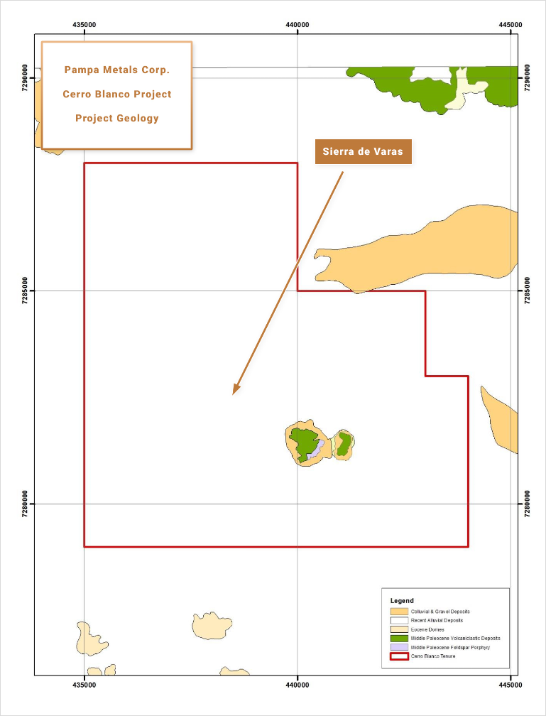
Cerro Blanco consists of a small hill displaying characteristics of the upper parts of a porphyry copper system, surrounded by extensive pampas filled with post-mineral gravels and mud flows. Hydrothermal alteration at Cerro Blanco is dominated by silicification together with a western advanced argillic assemblage of alunite + pyrophyllite + kaolinite +/- dickite, and a more sericite dominated eastern alteration assemblage.
EXPLORATION AND RESULTS TO DATE
The mapped alteration assemblages would place the current erosional levels at about the base of the lithocap to a porphyry copper system. The identification of “wormy” quartz veining within a pyrophyllite +/- kaolinite matrix in outcrop, particularly on the eastern side of the Cerro Blanco hill, has been described as being a transitional texture between the epithermal and porphyry environments. Minor surface geochemical sampling (soils) indicates anomalous arsenic and bismuth, also suggesting base of lithocap environment.
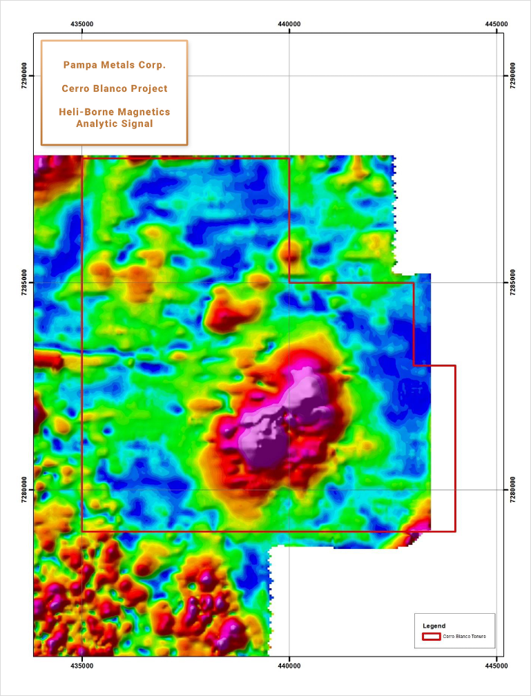
A significant magnetic anomaly partially underlays the Cerro Blanco hill and a covered area to the west and north. The anomaly is divided into two lobes and is approximately 3 km to 4 km in diameter. The magnetic feature likely represents a magmatic-intrusive centre that is in some way related to the hydrothermal alteration seen at surface, and may indicate either a prograde, hypogene porphyry copper core at depth, or a magnetic batholith, or a combination of the two. Other, smaller magnetic features beneath the surrounding and extensive post-mineral covered pampa, are also of interest as possible porphyry copper related targets.
Limited drilling (630 m – 2 RC holes) on the Cerro Blanco hill has cut porphyry-style alteration, but alteration zonation must be better understood, and deeper drilling contemplated. Drilling in the covered pampa areas, likely focused on the various magnetic anomalies, must also be contemplated,
INFRASTRUCTURE
Cerro Blanco is easily accessed, being located a short distance from the Pan-American Highway some 2.5 hours’ drive from either the port cities of Antofagasta or Taltal. A new high-tension power line has been installed alongside the main road. The property is situated at modest altitudes of 1,700 m to 1,800 m.
QUALIFIED PERSON
Mario
Orrego G, Geologist, MBA and Qualified Person of the Mining Commission of Chile, an independent consultant, is the Company’s Qualified Person for the purposes of National Instrument 43 101 Standards of Disclosures for Mineral Projects of the Canadian Securities Administrators, and is responsible for the accuracy of, and has verified the technical information in, this project summary, and has approved its written disclosure.
CERRO BLANCO SUMMARY KEY POINTS
LOCATION
Northern Chile, 130 km SE of Antofagasta
200 km SSW of Sierra Gorda (KGHM & Sumitomo) and Spence (BHPB)
OWNERSHIP
100% Pampa Metals
PROPERTY SIZE
~ 6,500 Ha
DEPOSIT TYPE
Porphyry Copper (+/- Au +/- Mo) & High-Sulphidation Epithermal Copper-Gold-Silver
STAGE
Early stage, partially outcropping porphyry and epithermal target with post-mineral gravel-covered
(pampa) extensions – geophysical anomalies – limited historic drilling
EXPLORATION PLANS
Geophysical surveying (3D Vector IP / Resistivity with combined Magneto-Telluric measurements, and improved Ground Magnetics Surveys)
Drill Testing of best anomalies
INFRASTRUCTURE
Easy access – close to Pan American Highway
Moderate altitudes of around 1,750 m