BEAUFORT PROPERTY
Beaufort is a granted exploration tenement located in the southwest of Victoria approximately 145km west of Melbourne, the capital of the State of Victoria. It is approximately 48km west of the regional town and historic gold mining centre of Ballarat.
The Beaufort Goldfield has been extensively mined in the past almost exclusively for alluvial gold, with an estimated 1.16 Moz of historical production. Local primary sources for the alluvial gold have not yet been identified
At Beaufort, an opportunity exists to explore for a hard rock source of a major alluvial goldfield along a structure that is known to host gold in the region.
BEAUFORT HIGHLIGHTS

1.16Moz historical alluvial productionwith no hard rock source identified*

Gold nuggets up to 400 ozrecovered from adjacent alluvial fields – supporting idea of proximal primary gold source*

Fosterville style mineralisation
not considered by previous explorers
targeted large tonnage, low grade
open pitable type deposits

Orientation soil sampling defined
a 2.5km long gold-arsenic-antimony trend common geochemical pathfinder association in Victorian goldfields. Trend open along strike.
BEAUFORT AT A GLANCE
LOCATION
145km west of Melbourne & 48km north-west of the regional town of Ballarat
SIZE
Single contiguous parcel covering 120km²
ACCESS
Multiple paved and gravel roads leading
off the Western highway that links
Melbourne and Adelaide
OWNERSHIP
100%
NSR
1% NSR, with option to buy back 0.5% for C$3.3M

EXPLORATION HISTORY

1853-1918
Discovery of gold and alluvial/ deep lead mining (No focus on hardrock exploration)

1972-73
Rio Tinto –scouts in northern part of the permit (rock sampling; mapping; hand auger samples and
stream sediment sampling (no drilling)

1987-89
Bendigo Gold Associates –Mapping; hand auger sampling; rock sampling; 2 RC lines over 100m strike

1991-97
Osprey Mining – soil and rock chip sampling; 867m of RC drilling (no systematic exploration program)

1992-98
High Lake Resources – targeting alluvial and quartz vein mineralization. Rock chip sampling; soil sampling (no systematic exploration program)

1998-2004
BHP Minerals –stakes the ground based on analogies with Sukhoi Log (100Moz Au).
However, BHP makes a corporate decision to exit gold
Placer Dome – Sedimentary Holdings acquired the permit from BHP. Sedimentary secured a JV with
Placer Dome. Work included rock chip sampling and shallow RAB Drilling on a 250 x 500m grid.
Placer Dome defined an anomalous trend over 6.5km but never followed up on their own
recommendations of 150m drill fences. Placer Dome were targeting a 10Moz open pitable deposit
in the context of US$280 Au. (Exploration geared towards wrong target type)

2007-09
Range River Resources – conducts review of past exploration, reconnaissance visits; recommended geophysical program. No further work was carried out(no systematic exploration program)

2016-17
E79 Founders –Secured priority ground during the market downturn

Target not systematically tested with geochemistry
and drilling
BEAUFORT TARGET

Alluvial goldfields & large nuggets all
associated with the N-S trending anticline
axis and thrust faults

Large and well defined target zones

Good structural setting
with cross cutting late structures

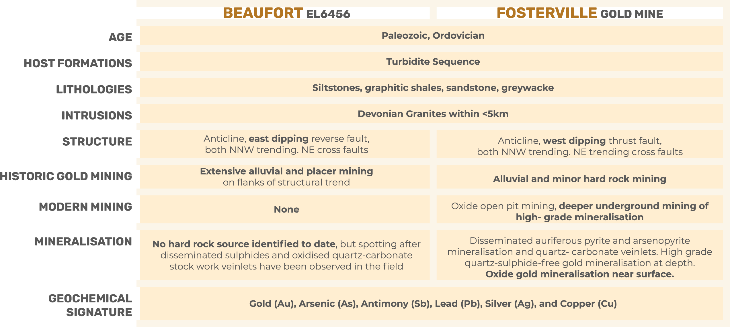
Setting analogous to numerous other
significant deposits in Victoria

Target has not been tested at depth and no systematic program aimed at Fosterville style mineralisation has been executed to date

SOIL SAMPLING PROGRAM
The 2020 soil grid successfully demonstrated:

A gold-arsenic-antimony geochemical fingerprint over thekey structural trends, an element association that is
the hallmark of several of the major gold districts in Victoria

The effectiveness of a 100 x 100 sampling gridof residual soil material in delineating kilometer scale anomalies

A 2000m long, gold-arsenic-antimony trendparalleling the regional structural trend

Indication of the presence of a second gold trend along the NE trending secondary structure, with a strike length of around 600m.
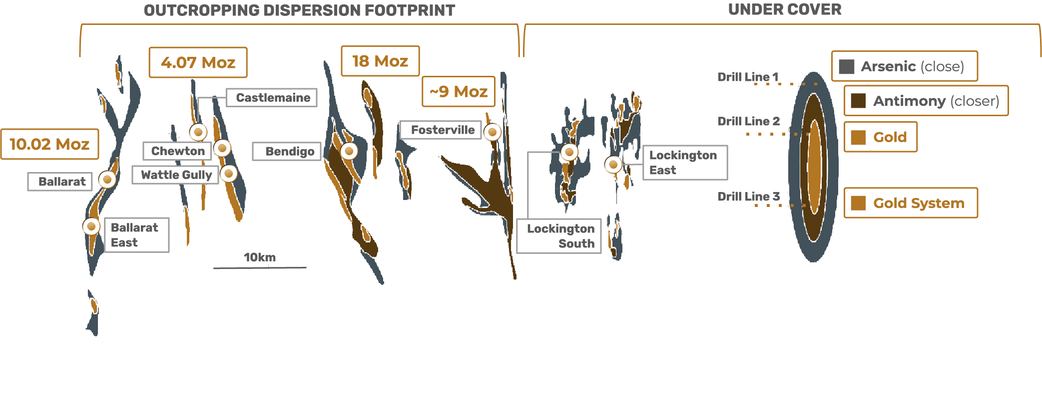
Location of Central block, the focus of this program, plus North & South Blocks. Notably, the 2km long anomaly which has been defined on the central block sits within a much larger mineralised trend (over 18km in strike), which has the potential to host a large gold system.

Identifying continuous dispersion over kilometres is a good indicator of a large gold system
Location of Central block, the focus of this program, plus North & South Blocks. Notably, the 2km long anomaly which has been defined on the central block sits within a much larger mineralised trend (over 18km in strike), which has the potential to host a large gold system.

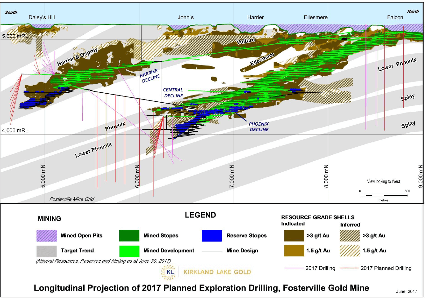
FOSTERVILLE GOLD MINE

1991
Near-surface low grade oxide mining

2005
Mined near surface for low grade mineralization

2015
Discovery of Eagle zone high grade mineralization

2016
Discovery of gold bearing Harrier zone at depth

2017
Down plunge extension of Swan zone
FOSTERVILLE SIMILARITIES