BEAUFOR MINE
Over 1.1 million ounces of gold produced and strong exploration potential
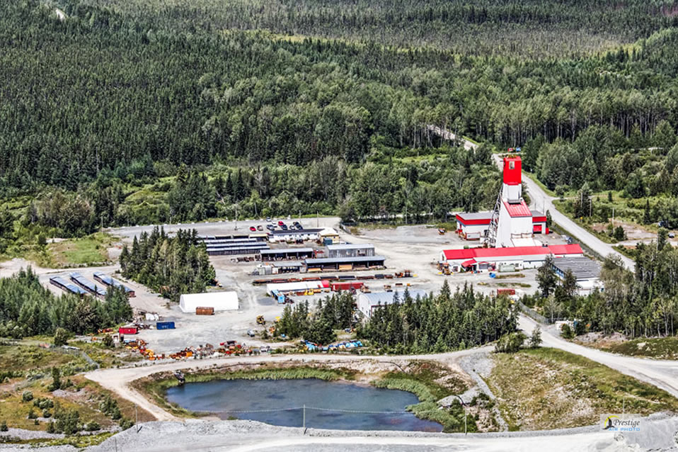
Monarch holds a 100% interest in the Beaufor Mine, which includes two mining leases, a mining concession and 23 mining claims covering an area of 6.91 km². The mine is located at about 20 kilometres northeast of the town of Val-d’Or, in the Abitibi-East township, in the Province of Quebec. The Beaufor Mine is an underground mine.
On June 27, 2019, production activities at the Beaufor Mine have been temporarily suspended and the mine was placed on care and maintenance.
On May 7, 2020, Monarch announced that it has signed an agreement with Caisse de dépôt et placement du Québec to sell a 3% net smelter return royalty on gold production at the Beaufor Mine for $5 million.
Beaufor Mine
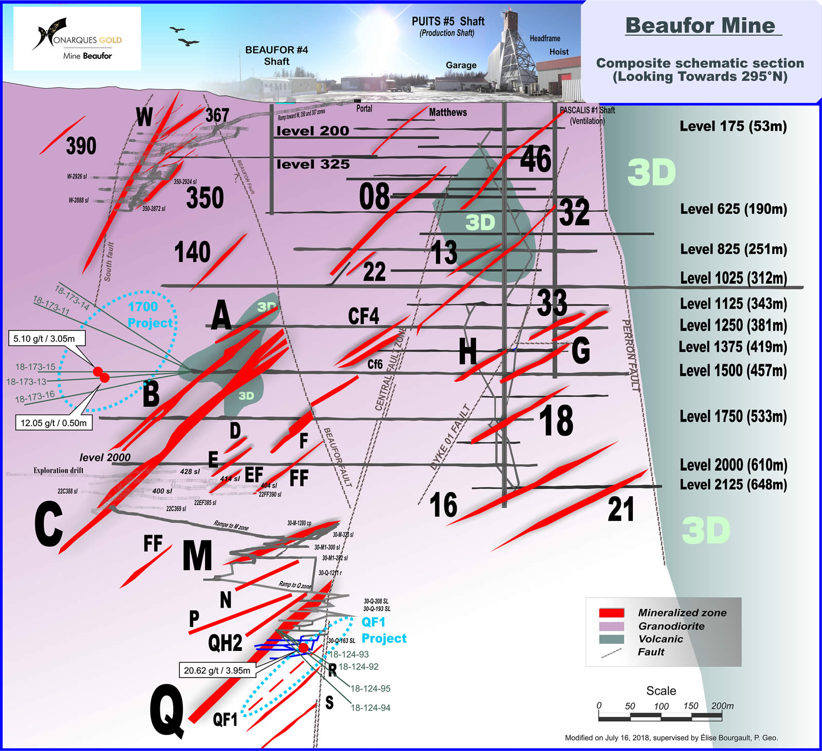
Composite Schematic Section
42,500-metre drilling program
The planned exploration program will be one of the largest exploration programs ever undertaken on the Beaufor property, consisting of approximately 270 drill holes for a total of 42,500 metres (see Beaufor Presentation). Exploration drilling will be done in several phases, including:
- Underground work in proximity to the exploration targets of the mine (high-grade intervals and isolated resource blocks)
- Near-surface and mine targets
- Targets below the current mine workings
- Regional exploration targets
Underground work in proximity to the exploration targets of the mine
This initial phase, representing the bulk of the exploration drilling, will focus on the underground near-mine targets defined by the recent 3D modelling (see Figure 1). These holes will test areas near historical high-grade drill intersections and areas associated with known vein structures that remain open. These targets are all defined by high-grade intersections located near the existing underground infrastructure, thus requiring minimal development for mining purposes. They are also all located above the mine’s lowest development level (above 900 metres). These targets can easily be tested from the available underground workings, with the majority of the holes less than 200 metres long.

The second type of target related to underground near-mine targets will be the follow-up of isolated resource blocks that still have significant room for expansion. These resource blocks are typically defined by a single drill hole along a known mineralized structure, but continuity has not been demonstrated due to a lack of nearby drilling.
Near-surface and mine targets
The second type of target related to underground near-mine targets will be the follow-up of isolated resource blocks that still have significant room for expansion. These resource blocks are typically defined by a single drill hole along a known mineralized structure, but continuity has not been demonstrated due to a lack of nearby drilling.
Targets below the current mine workings
A program of exploration drilling of the area below the current mine workings (below 900 metres) will be undertaken to continue testing the extension of the known mineralization at depth, where mining left off prior to the temporary shutdown (see Figure 3). Recent wide-spaced drilling below the bottom of the mine has confirmed the extension of the mineralization. The planned drilling will target specific areas defined by previous high-grade intersections in an area extending down to 230 metres below the current workings.

Regional exploration targets
The final phase of the exploration drilling will consist of surface drill holes to test regional targets defined by historical intersections and potential structures beyond the current limits of the underground infrastructure (see Figure 4).

Resources
Estimated mineral resource table
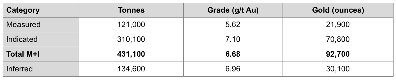
Mineral Resource Estimate notes:
- The independent and qualified person for the 2020 MRE, as defined by NI 43-101, is Carl Pelletier, P.Geo. (InnovExplo Inc.), and the effective date is December 18, 2020.
- These mineral resources are not mineral reserves as they do not have demonstrated economic viability. The mineral resource estimates follow CIM Definition Standards and Guidelines.
- A capping of 68.5 g/t Au on assays was applied for zones 8, B, M, M1 and Q, and 34.25 g/t for all other zones. The DDH intercepts (min. 2.4 m) were capped at 16.5 g/t.
- The estimate method was polygonal on cross-sections with a minimum width of 2.4 m using a density of 2.75 t/m3 for the 63 mineralized zones.
- Measured resource polygons extend 8 m above and below development and up to 10 m laterally. Indicated resource polygons extend up to 20 m from DDH intercepts, along dip and along strike and a minimum of 2 polygons need to be in contact. Inferred resource polygons extend up to 40 m from DDH intercepts, along dip and along strike where a drill spacing ranges from 20 m to 40 m and/or in areas of isolated drill holes where mineralization is known.
- The reasonable prospect for an eventual economical extraction is met by having a reasonable minimum width for the polygons, a cut-off grade of 3.20 g/t Au, application of constraining volumes on the blocks (potential underground scenario) below a 30 m crown pillar. The cut-off grades inputs are: a gold price of USD1,612/oz, a CAD:USD exchange rate of 1.34; a mining cost of $100/t for the long hole method and $145/t for the room and pillar method; a processing cost of $50/t; and G&A and environment of $13/t and includes the royalty of 1.0% and a refinery charge of $5/t. The cut-off grades should be re-evaluated in light of future prevailing market conditions (metal prices, exchange rate, mining cost, etc.).
- Results are presented in situ. Ounce (troy) = metric tons x grade / 31.10348. The number of tonnes and ounces was rounded to the nearest hundred. Any discrepancies in the totals are due to rounding effects; rounding followed the recommendations as per NI 43-101.
- InnovExplo Inc. is not aware of any known environmental, permitting, legal, title-related, taxation, socio-political, marketing or other relevant issue that could materially affect the mineral resource estimate.
Geology
The Beaufor deposit is included in the Bourlamaque granodiorite. Gold mineralization occurs in veins associated with shear zones that moderately dip south. The mineralization is associated with quartz-tourmaline veins resulting from the filling of shear and extension fractures. The gold-bearing veins show a close association with mafic dykes intruding on and undercutting the granodiorite. The dykes seem to have influenced the structural control of the gold-bearing veins.
Mineralization
Gold-bearing veins at the Beaufor Mine consist of quartz-tourmaline-pyrite veins, typical of Archean epigenetic lode gold deposits, that cross-cut the Bourlamaque Batholith. Mafic dykes that predate the mineralization are associated with shear- hosted gold-bearing veins. Shallowly dipping extensional gold-bearing veins are commonly observed at the Beaufor Mine. Shear zones striking N70o and dipping steeply to the southwest control the opening and gold enrichment of veins.
All the gold-bearing veins are contained in a strongly-altered granodiorite in the form of chlorite-silica forming anastomosing corridors of 5 m to 30 m in thickness. The veins at the Beaufor Mine form sometimes panels of more than 300 m in length by 350 m in height. The thickness of the veins varies from 5 cm to 5 m, but generally, the thickness of the quartz veining system 30 cm to 120 cm. The zones are limited by the Beaufor fault (N115o/65o-75o) and by a parallel system of shears (N70o/sub vertical).