OWL LAKE PROJECT
| Right Geology <ul style="margin: 5px 0px !important; padding-top: 0px; padding-right: 0px; padding-bottom: 0px; padding-left: 3em !important; list-style: outside disc !important;"><li style="margin: 3px 0px 0px !important; padding-top: 0px; padding-right: 0px; padding-bottom: 0px; padding-left: 5px !important; list-style: outside disc !important;">Barrick operates their Hemlo mine producing more than 220,000 ounces annually</li><li style="margin: 3px 0px 0px !important; padding-top: 0px; padding-right: 0px; padding-bottom: 0px; padding-left: 5px !important; list-style: outside disc !important;">Barrick recently committed to upgrading the project to a Tier 2 project</li><li style="margin: 3px 0px 0px !important; padding-top: 0px; padding-right: 0px; padding-bottom: 0px; padding-left: 5px !important; list-style: outside disc !important;">Our project is located approx. 80 km west of Barrick's Hemlo gold camp</li><li style="margin: 3px 0px 0px !important; padding-top: 0px; padding-right: 0px; padding-bottom: 0px; padding-left: 5px !important; list-style: outside disc !important;">Barrick recently announced 2 JV earn-in deals on very early-stage projects with small juniors</li></ul> |
Location
Thunder Bay Mining Division
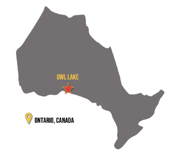
The Owl Lake property is located in Northern Ontario (Figure 1), within the Thunder Bay South Mining Division and approximately 225 km east of Thunder Bay. The Property comprises 715 claims covering a total area of 15,158 ha, or 151.58 sq/km, and is one of the largest land positions covering the highly prospective Hemlo–Schreiber Greenstone Belt (HSGB) (Figure 2). The southern boundary of the property is located approximately 15 km north of Lake Superior and approximately 10 to 15 km north of the towns of Terrace Bay and Schreiber (Figure 3). The property is accessed by logging roads out of Terrace Bay and by various logging roads from north of the Property.
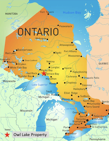
Figure 1: Location of Owl Lake Project
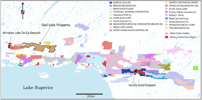
Figure 2: Mining claims covering the Hemlo–Schreiber Greenstone Belt and adjacent area.
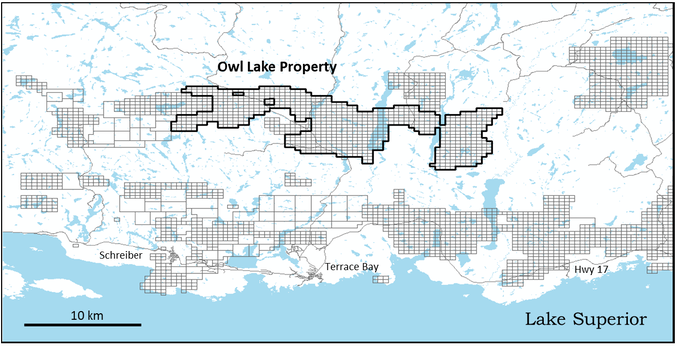
Figure 3: Owl Lake Claims, Location, and Access
Geology and Mineralization
Archean greenstone belts in the Superior Province have been, and are, a major source of gold and base metals with gold occurring as higher-grade lode deposits and as larger tonnage, lower-grade disseminated deposits and base metal mineralization, Cu-Zn-Pb-Ag-Au, occurring in Volcanogenic Massive Sulfide (VMS) deposits. Examples of greenstone hosted gold include the Timmins, Kirkland Lake, and Val-d’Or districts in the Abitibi Greenstone Belt and the Red Lake deposits in the Red Lake – Uchi Greenstone Belt. Combined, these greenstone hosted gold districts have produced in excess of 150 million ounces (Moz) Au. Examples of VMS districts include Noranda and Matagami in Quebec and Sturgeon Lake in Ontario. The giant Kidd Creek VMS deposit near Timmins produced 147 million tonnes (Mt) at average grades of 2.31% Cu, 0.22% Pb, 6.18% Zn, 87 grams per tonne (gpt) Ag, and 0.01 g/t Au.
The Owl Lake property is located in the Hemlo – Schreiber Greenstone Belt (HSGB) which has a strike length of approximately 140 km across the north shore of Lake Superior (Figure 4). A later alkalic intrusive complex divides the HSGB into eastern and western domains (Figure 4). The Hemlo Gold deposit, located in the eastern HSGB, has produced more than 20 Moz Au and has resources of 3.1 Moz measured and indicated and 1.0 Moz inferred (Barrick Gold Annual Report 2019). Winston Lake is a VMS deposit located in the western HSGB approximately 8 km west of the Owl Lake property. From 1988 to 1999, Winston Lake produced 2.68 Mt of ore at average grades of 12.05% Zn, 1.05% Cu, 31.37 g/t Ag, and 1.07 g/t Au. During August 2019, Superior Lake Resources Inc. announced a positive feasibility study for the Winston Lake property based on measured and indicated resources 2.35 Mt grading 17.7 % Zn, 0.6% Cu, 26.2 g/t Ag, and 0.2 g/t Au.
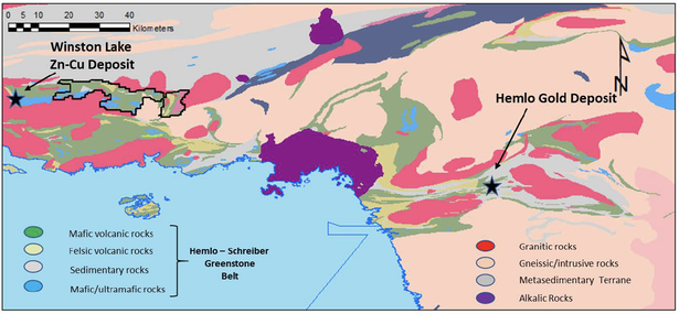
Figure 4: Owl Lake Property, Regional Geological Setting
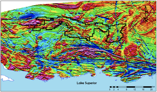
The Owl Lake property, located in the western HSGB, is underlain dominantly by mafic to felsic volcanic rocks and lesser mafic to ultramafic intrusive rocks and sedimentary rocks (Figure 5). The eastern most part of the Owl Lake property includes a syenitic intrusion. The property is bounded in the north by granitic and metasedimentary rocks, to the south by granitic rocks, and to the east by metamorphic rocks. The volcanic rocks underlying the Owl Lake property are continuous on to claims contiguous to the west. Northwest-southeast trending structures are interpreted to traverse the property (Figure 5) and are apparent in the map of total magnetic intensity (Figure 6). There is a folding of the magnetic stratigraphy to an east-west orientation on the western part of the property.
The Ontario Mineral Deposit Inventory (MDI) database indicates nine mineral occurrences on the Owl Lake property. The occurrences are generally described as quartz veins hosted by mafic volcanic rocks, intercalated mafic volcanic and sedimentary rocks, and granodiorite. Commonly, porphyritic intrusive rocks are described as host rocks and cross cutting the host rocks. Sulphide minerals occurring at the showings are pyrite, molybdenite, chalcopyrite, pyrrhotite, and sphalerite (Figure 5). Assays are irregularly reported for the showings. There are no assays by the owners included for 6 of the 9 records in the MDI. However, grab samples have been taken by the MNDM Resident Geologist for 3 of the 6 showings. One of the MDI records (the Cowan Occurrence) includes description of man-portable drill hole which returned 5.72 g/t Au over 1.52 m. Grades of 1 g/t Au are reported from 2 of the other showings.
The Ontario Drill Hole Database (ODHD) contains 17 historical holes drilled within the limits of the Owl Lake property. Ten of these holes, drilled in 2 campaigns in 1958 and 1986, were drilled along the northern boundary to test a conductive horizon derived from an airborne survey and targeting base metal mineralization (Figure 5). Anomalous Cu and Zn assays are reported, and trace Au is reported in one instance. Three holes were drilled on the Cowan Occurrence where the MDI record indicates a historical intersection of 5.72 g/t Au over 1.52 m (Figure 5). All holes intersected significant pyrite and pyrrhotite mineralization and describe quartz veining however no assays are reported. Four holes were drilled on a Molybdenite occurrence in the south-central part of the property (Figure 5) targeting molybdenum mineralization. Molybdenite was intersected, associated with quartz veins in granitic host rocks, however no assays were reported.
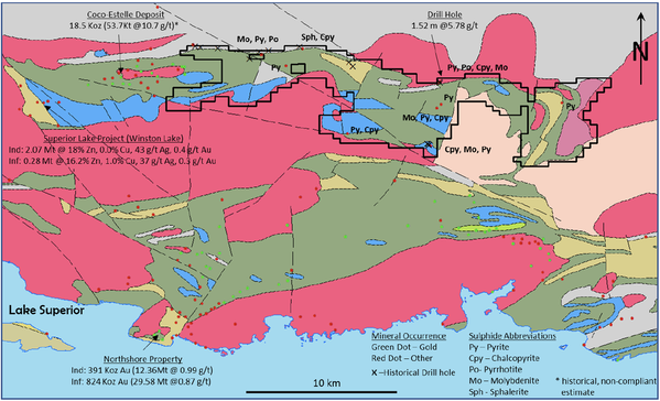
Figure 5: Owl Lake Property, Local Setting and Property Showings.
The western domain of the HSGB includes a number of mineral occurrences which include Au occurrences, occurrences of base metal mineralization, and other mineral occurrences. Advanced gold projects in the western domain include the Northshore property which contains indicated resources of 391,000 ounces and inferred resources of 824,000 ounces Au and the Big Duck Lake property which includes the Coco-Estelle deposit which contains a historical estimate (non-NI 43-101 compliant) of 18.5 Koz at an average grade of 10.7 g.t Au. The western domain of the HSGB also contains the Superior Lake project (historical Winston Lake Mine) which contains measured and indicated resources 2.35 Mt grading 17.7 % Zn, 0.6% Cu, 26.2 g/t Ag, and 0.2 g/t Au in a positive feasibility study.
Figure 6: Total Magnetic Intensity, HSGB, Western Domain.
Exploration Potential
The Owl Lake property is underlain by Archean Greenstone Belt rocks which, across the Superior Province of Canada and globally, are major sources for gold and base metal mineralization. The HSGB belt is a significant historical producer of both gold and base metals and contains an operating mine and advanced projects with established mineral resources. The Owl Lake property contains a number of sulphide showings and a reported Au drill intercept of 5.78 g/t Au over 1.52 m. The volcanic rocks underlying the Owl Lake property are continuous to the west where they host an advanced gold exploration project that includes significant recent drill intercepts and a high-grade historical resource estimate.
In addition to the review of the Ontario Mineral Deposit Inventory and Ontario Drill Hole Database, the author completed a review of the types and distribution of historical exploration work completed on the Owl Lake property and adjacent ground. It appears that the dominant type of work completed in the region has been airborne magnetic and electromagnetic surveys and that the primary target was likely base metal VMS mineralization. There have been some prospecting initiatives within the claim limits but apparently of limited extent. In summary, the amount and type of historical work completed on the property appears to be limited and does not preclude the Owl Lake property from being a quality early-stage Au exploration opportunity based on geological setting, Au projects proximal to the property, and quartz vein, sulphide, and Au mineralization on the property. The size of the Owl Lake Property provides for a regional scale exploration opportunity.
As a final comment, it is noted that molybdenite is strongly associated with Au at Hemlo occurring as fine to very fine grains in altered and sheared host metasedimentary and intrusive porphyritic host rocks. This mode of occurrence differs from the descriptions of molybdenite on the Owl Lake property being associated with veins hosted by granitic rocks. The Au-Mo metallogeny of the Owl Lake property, and correlation with the Hemlo deposit, remains unknown and despite the differences in mode of occurrence, the presence of molybdenite should be considered significant at the early stage of exploration on the Owl Lake property and in the formulation of exploration models for the property.
The author has reviewed the distribution and content of public domain data available to the extent required to be satisfied that the Owl Lake property represents an early-stage exploration opportunity for the discovery of gold. The author recommends that the first step in development of the Owl Lake property be the detailed and inclusive compilation and interpretation of all available data including historical exploration data, geological survey data, geophysical data, remote sensing data, base map data, etc. This compilation and interpretation would form the basis for the formulation of an exploration strategy.
Phase 1
Prospecting and geological mapping:Objectives to include evaluation of historical geological mapping, evaluation of mapped structures, prospecting and mapping on prioritized magnetic lineaments, evaluation of historical showings, mapping and evaluation of Quaternary geology and determination of appropriate geochemical exploration techniques.
Soil/till geochemistry: Based on field evaluation, design, and execution of surface geochemical survey.
Airborne magnetic and electromagnetic survey. Pending the results of the compilation and interpretation and preliminary field work that includes the confirmation of the limits of prospective rock types, an airborne survey may be appropriate.
Airborne magnetic and electromagnetic survey: Pending the results of the compilation and interpretation and preliminary field work that includes the confirmation of the limits of prospective rock types, an airborne survey may be appropriate.
Phase 2
Targeted exploration based on Phase 1 results: Applied exploration to likely include targeted geological mapping, trenching, and outcrop stripping, ground geophysical surveys, and other as deemed appropriate. A primary objective of this phase of exploration is the definition of drill targets