BLOCK 3
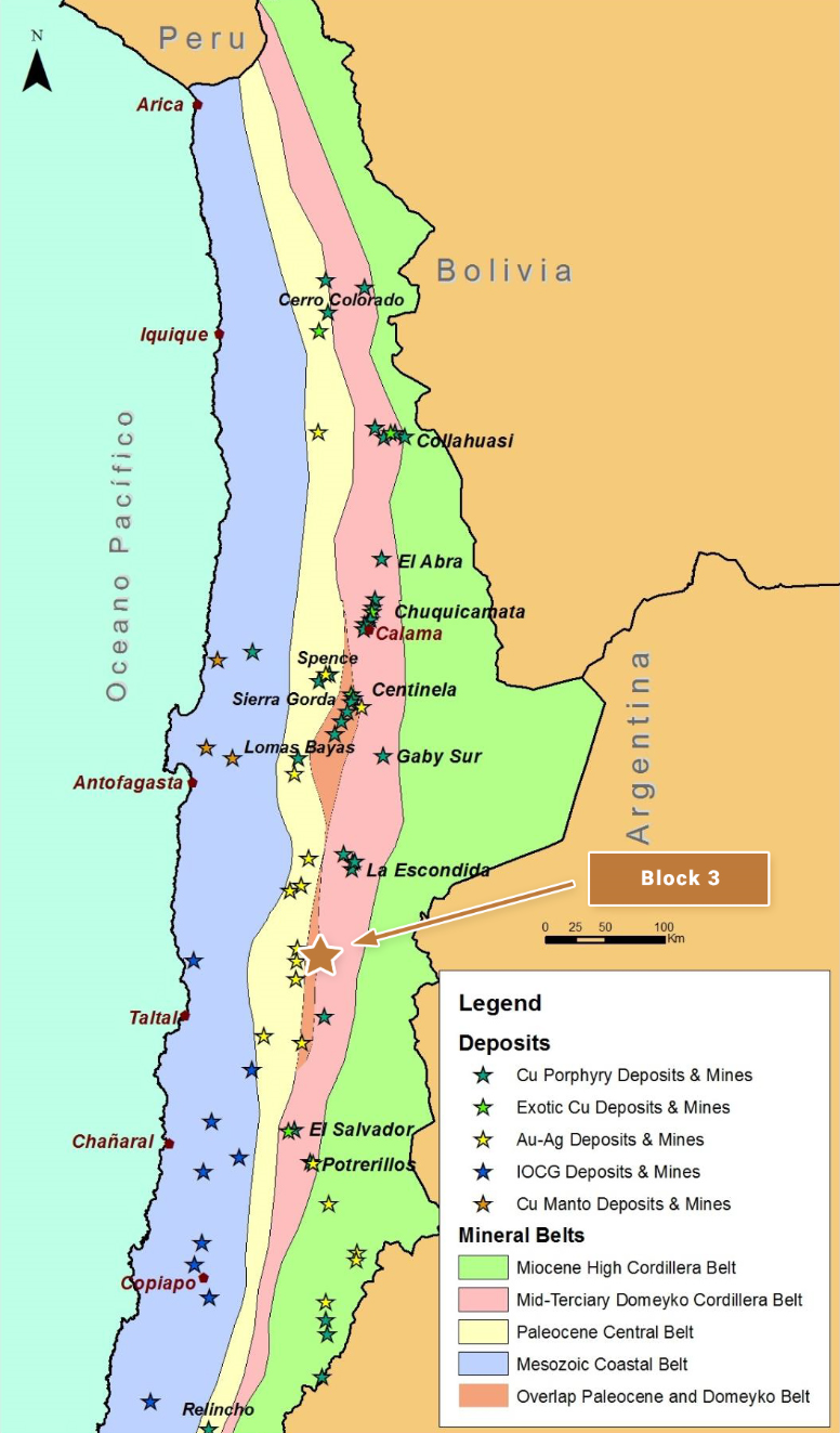
Block 3 is located in northern Chile and is centered approximately 170 km southeast of the coastal port city of Antofagasta. The property is situated along one of the most geologically productive segments of the Andean Cordillera, along trend and approximately 50 km to 60 km south-southwest of the giant La Escondida copper mine and other related copper deposits in the district (BHP Billiton, Rio Tinto, Antofagasta Minerals and Barrick Gold). The reader is cautioned that there is no evidence to date that a comparable mineral resource could be found at Block 3.
OWNERSHIP
The Block 3 project area consists of approximately 10,100 Ha of 100% owned tenement comprising both exploration and mining concessions.
The property is subject to an underlying 1% NSR Royalty on production of all metals.
GEOLOGY AND DEPOSIT TYPE
Block 3 lies along the mid Tertiary porphyry copper belt of northern Chile the Domeyko Cordillera that is host to three of the world’s top five copper mining districts at Collahuasi, Chuquicamata and La Escondida (the world’s single largest copper mine)
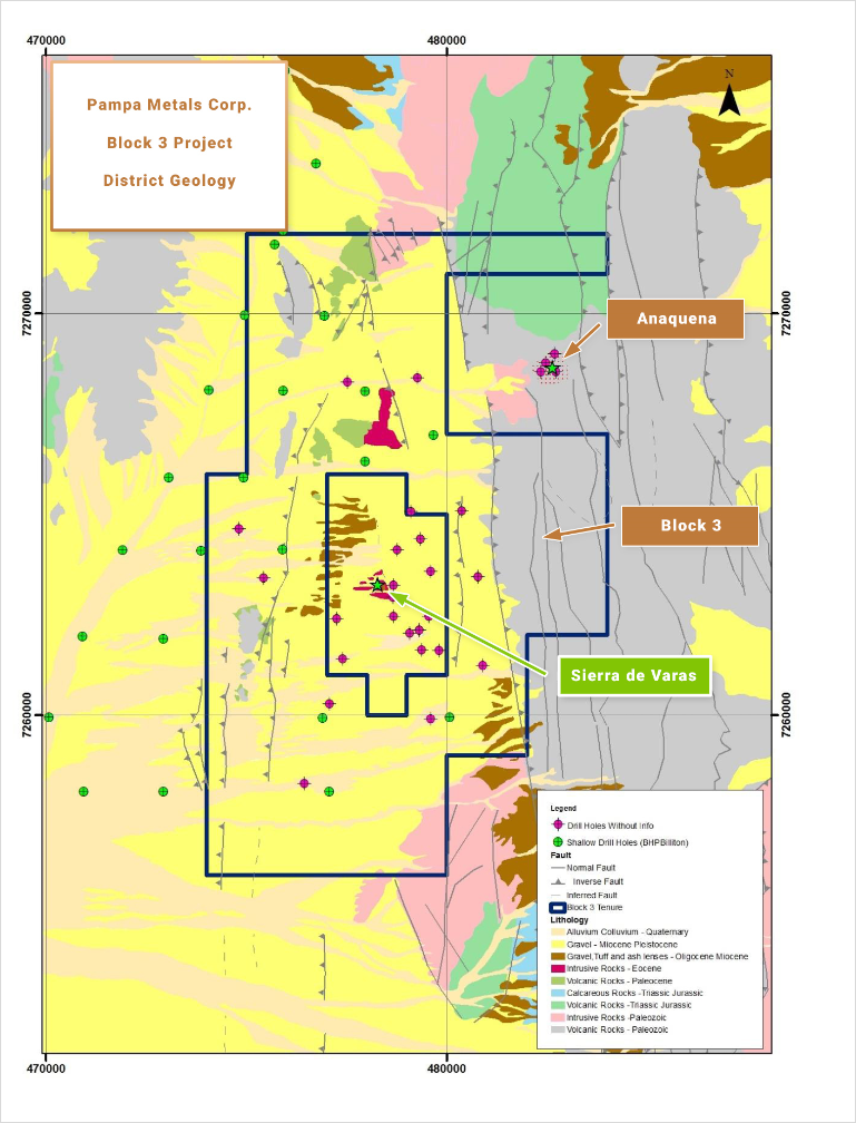
Two known porphyry related prospects, Anaquena and Sierra de Varas, are located adjacent to, or as a third party in holdings within, the Block 3 property
• The Anaquena porphyry related system is located within the uplifted Paleozoic basement block that flanks the eastern margin of the Block 3 property historically drilled by David Lowell and more recently by First Quantum
• The Sierra de Varas porphyry related system is situated within a third party in holding located in the Block 3 property historically drilled by Anglo American and others
Both porphyry prospects occur in close relation to the north south trending Sierra de Varas fault system (to the east and west respectively), which represents a master fault strand of the Domeyko Cordillera mineral belt
EXPLORATION AND RESULTS TO DATE
Large portions of the Block 3 property are characterised by post-mineral Miocene to Recent alluvial and volcanic cover generally less than 150m thick, where the underlying geology is obscured. Elevated, north-south trending sierras border the western and eastern margins of the property, and consist of Paleozoic rhyolitic and dacitic lavas, Paleozoic granites, and Jurassic limestones.
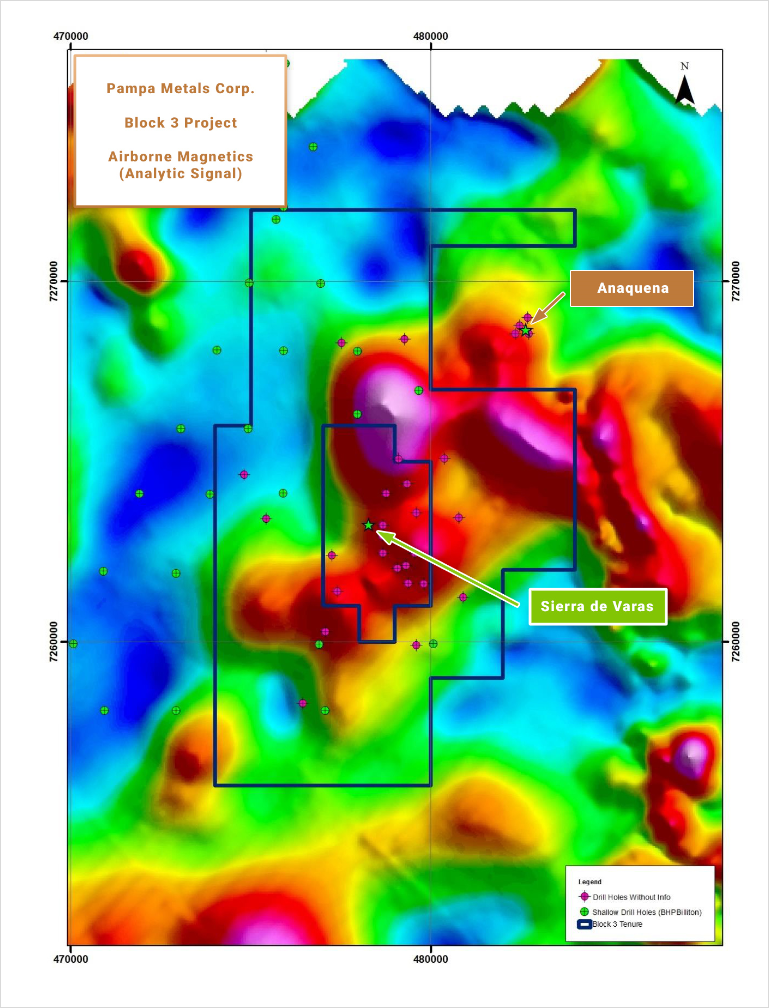
A number of magnetic features from regional magnetics data suggest a magmatic intrusive complex centered around the Sierra de Varas porphyry system, including extensions onto the Block 3 post-mineral covered ground controlled by Pampa Metals. It is proposed that the possible magmatic intrusive complex could be related to one or more untested porphyry copper targets.
Apart from the historic drill testing described above, BHP completed 39 vertical, shallow RC drill holes in 2014-2015 over post-mineral covered areas, extending outside of the current Block 3 property boundary, on an approximately 2 km x 2.5 km grid totaling 6,548 m. The intention was to penetrate the post-mineral cover and explore for hydrothermal alteration. Key areas of interest not tested by this program have been identified on the Block 3 property related to the magnetic anomalies described.
INFRASTRUCTURE
Access to the property is via a variety of moderate to good quality dirt roads leading off from the Pan-American Highway to the west, and other access points including from the Guanaco mine, about 60 km to the southwest. Total journey time from Antofagasta is about 4 to 5 hours, and from Taltal about 4 hours. Altitudes vary from approximately 2,700 m in the post-mineral covered pampas to around 3,800 m in the sierras.
QUALIFIED PERSON
Mario
Orrego G, Geologist, MBA and Qualified Person of the Mining Commission of Chile, an independent consultant, is the Company’s Qualified Person for the purposes of National Instrument 43 101 Standards of Disclosures for Mineral Projects of the Canadian Securities Administrators, and is responsible for the accuracy of, and has verified the technical information in, this project summary, and has approved its written disclosure.
BLOCK 3 SUMMARY KEY POINTS
LOCATION
Northern Chile, 170 km SE of Antofagasta
Centred 50 60 km S SW of the giant La Escondida Mining District (BHP Billiton Rio Tinto Other)
OWNERSHIP
100% Pampa Metals
PROPERTY SIZE
~ 10,000 Ha
DEPOSIT TYPE
Porphyry Copper (+/- Au +/- Mo)
STAGE
Early stage post mineral gravel covered ( exploration target geophysical anomalies drill testing of neighboring targets wide spaced shallow drilling within property
EXPLORATION PLANS
Geophysical surveying 3 D Vector IP Resistivity with combined Magneto Telluric measurements, and improved Ground Magnetics Surveys)
Drill Testing of best anomalies
INFRASTRUCTURE
Moderate access dirt roads from Pan American Highway 70 km to the west
Altitudes ranging from approximately 2 700 m to 3 800 m