79 RESOURCES
LOCATION & GEOLOGY
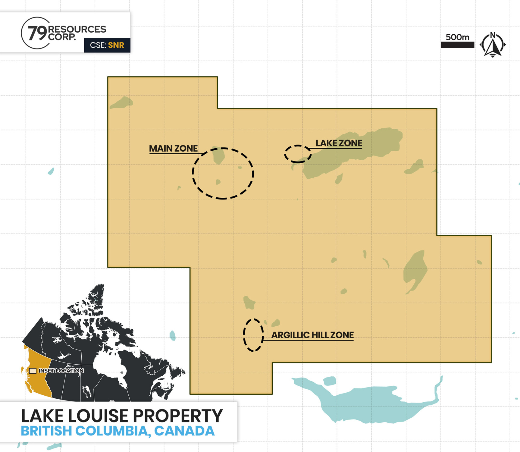
The Louise Lake property is located 35km west of Smithers, BC, and is comprised of 8 mineral claims totalling approx. 1,825 ha. The property occurs along the east-northeast trending regional-scale Coal Creek lineament, forming the contact between lower Cretaceous Skeena Group sediments and volcanics to the northwest, and lower to middle Jurassic Hazelton Group volcanics and sediments to the southeast. Volcanic units occur primarily in the mineralized “Main Zone” area, where they have been intruded by several east-west trending, moderately north-dipping slabs of feldspar porphyritic monzonite.
PROPERTY HISTORY
1968
- First staked by Mastodon-Highland Bell Mines
- Mastodon completed geological mapping, soil geochemical and induced polarization, geophysical surveying, and trenching exposing an area of Cu-Mo mineralization called the “Main Zone” north of the Coal Creek fault
1988
- Corona Gold Corp. conducted a detailed geological mapping and soil, rock and silt sampling program that identified numerous Cu ± Mo ± Au anomalies proximal to, but not always directly overlying, the Main Zone
- A follow-up 1989 five-hole 916-metre diamond drill program at the eastern Main Zone area returned strongly anomalous Cu-Au ± Mo mineralization with fairly uniform metal values
1989
- Placer Dome Inc. determined that the Main Zone represents a transitional zone between upper levels of a porphyry system and an evolved hydrothermal zone
1992
- Equity Silver Mines drill program concludes that that the deposit contained “an estimated resources of 50 million tonnes grading 0.3% Cu and 0.3 g/t Au with some payable molybdenum
- Equity also drilled one hole to the east and intersected a zone referred to as the “Lake Zone”, comprising chalcopyrite-sphalerite veins with Au and Ag values
2006
- North American Gem drill program determines the base of the deposit to be a flat-lying thrust fault named the “Terminator”
- Follow-up drilling outlines the deposit size and tenor and indicates the underlying “Sub-Terminator” portion occurring to the west-northwest of the Main Zone
MINERALIZATION
Two separate mineralized prospects occur within the core area of the Louise Lake property: the Main Zone and the Lake Zone. The highest copper and gold grades occur in these areas, returning values to 0.592% Cu with 0.586 g/t Au across 35.7 metres, and locally exceeding 0.800% Cu and 0.800 g/t Au.
Main Zone
The Main Zone mineralization is a tabular feature dipping from 30º to 40º to the north and has been traced along strike for about 1,000 metres. It comprises two major horizons extending at 80º – 260º: the shallower lower grade “North Horizon” and the underlying much broader, higher-grade “South Horizon”.
Mineralization at the Main Zone comprises fine-grained disseminated and vein-controlled sulphides. The sulphide grains comprise an almost even mixture of fine-grained chalcopyrite and enargrite (a Cu-As sulphide) locally comprising up to 4% of the rock mass. Several pulses of vein stockwork emplacement have occurred, with quartz-pyrite veins crosscut by later nearly massive pyrite veins. Copper-gold ratios show an approximate mineralized zone-wide average ratio of 1% Cu: 1 g/t Au. Mo-bearing quartz stringers occur on surface in the eastern Main Zone area and in basal portions of the western area. Silver values reported from drill core analysis are generally less than 2.0 g/t. The Main Zone is interpreted to be bounded by a basal flat-lying fault at depths to 300m, called the “Terminator” with a minimal displacement of several hundred metres.
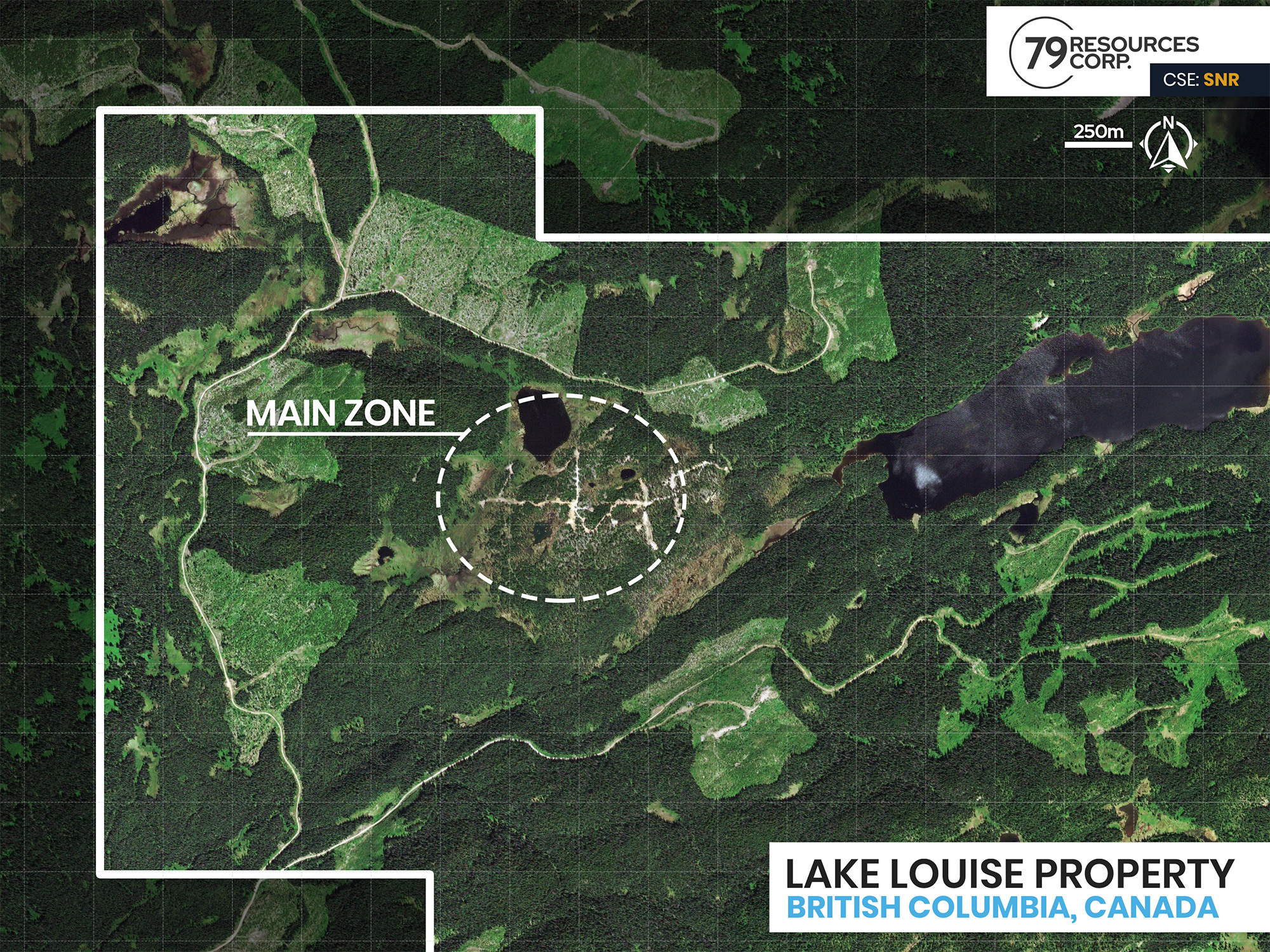
The Main Zone is classed as a “calc-alkaline suite” porphyry system, like deposits of the Eocene Babine Igneous Suite. The primary exploration model is porphyry-style mineralization, although potential satellite occurrences of base metal veining, “Bonanza-style” gold veins and zones of gold +/-silver bearing epithermal mineralization are also viable targets. Core areas consist of intrusivehosted disseminated copper sulphides, largely chalcopyrite and bornite, commonly with accessory molybdenite and gold. Copper mineralization was originally believed to be tennantite (also a Cu-Fe-As sulphide), which would have signified upper levels of a porphyry system. The revised mineralogy renders the location of the Main Zone respective to the overall setting of the porphyry system as uncertain.
Terminator Zone
A 2007 program identified higher-grade gold mineralization at depth in northeastern areas, overlying the Terminator fault. The Au: Cu ratio is considerably higher than the 1:1 ratio occurring throughout most of the Main Zone. Low-grade sub-Terminator mineralization intersected to the northwest in 2007, was found to have metal ratios and rock fabric similar to outlying areas of the Main Zone. A single hole intersected minor massive lead-zinc veining at depth, targeting a projected underlying portion of the Main Zone to the east-northeast and somewhat west of the Lake Zone. The 2008 drilling focused partly on delineating sub-Terminator mineralization west-northwest of the Main Zone. Several holes confirmed the presence of a flat lying slab of sub-Terminator-hosted Main Zone-style mineralization. In all intercepts, the sub - “Terminator” mineralization was truncated by another flat-lying mylonitic fault, called the “Sub-Terminator fault”. The westernmost hole returned low-grade mineralization below the “Sub-Terminator” fault with similar grade ratios to the Main Zone mineralization. This indicates another mineralized slab extends farther west-northwest.
Lake Zone
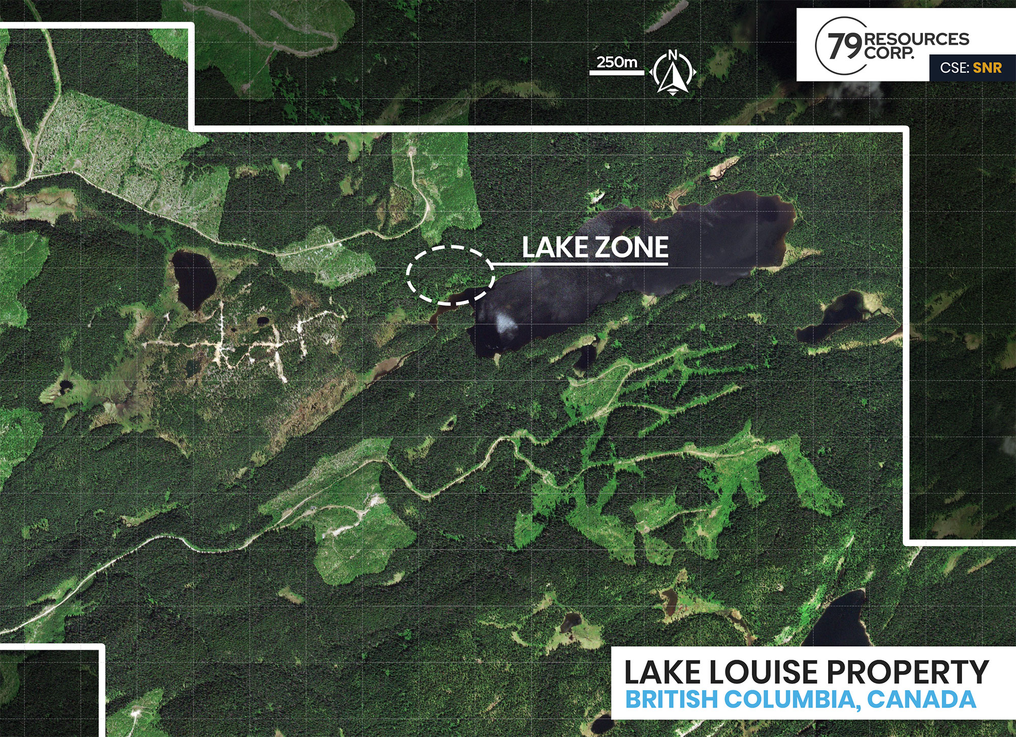
The Lake Zone, occurring about 1.2 km to the east along the north shore of Louise Lake, hosts vein and fracture-hosted zinc-silver mineralization. Work in 2006 by SRK indicated the deposit has a footprint in plain view of almost 500 metres, extends to a depth of 300 metres, and indicates that central portions have lower copper-equivalent grades than the western and eastern portions.
2019 EXPLORATION
Phase 1 of the 2019 program, comprised of geological mapping, rock sampling, and soil geochemical sampling along existing and former logging roads, confirmed the presence of Main Zone-style Cu-Mo-Au-Ag mineralization. Elevated Mo and arsenic (As) values were returned from rock sampling of pyritic conglomerate units near the terminus of the driveable logging road.
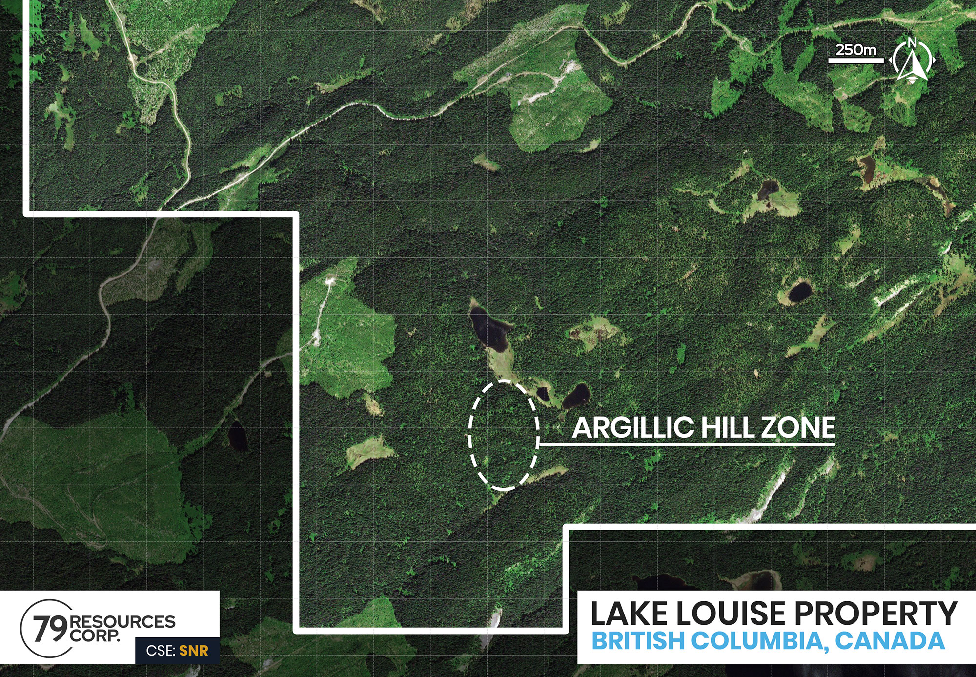
Phase 2 comprised a ground magnetic surveying program along east-west oriented lines centered on “Argillic Hill”, an area of argillic (clay) alteration and pyritization in the southwest property area. A total of 52.7 line km, including 3.45 line km of north-south tie lines, were surveyed. The survey identified a NESW trending magnetic low feature, which may represent a significant structural lineament. This separates linear magnetic signatures to the east, from more arcuate features to the west, possibly representing folded stratigraphy accreted onto to more linear stratigraphy to the southeast of the lineament. The survey also revealed an ovoid magnetic high signature coincident with “Argillic Hill” alteration, directly west of the magnetic low feature.
LOOKING FORWARD
The proposed exploration program is recommended to comprise two phases.
Phase one would target the Argillic Hill occurrence and comprise a surface program of grid soil geochemical sampling, combined with detailed geological mapping, rock sampling and prospecting. Contingent on successful results obtained during the first phase of exploration, the phase two program would comprise 750 – 1000 metres of diamond drilling over several holes to test for porphyry style mineralization at the Argillic Hill target. Also recommended during this phase is a single 350 metre due diligence style hole targeting mineralization noted by previous exploration programs.