BLOCK 2
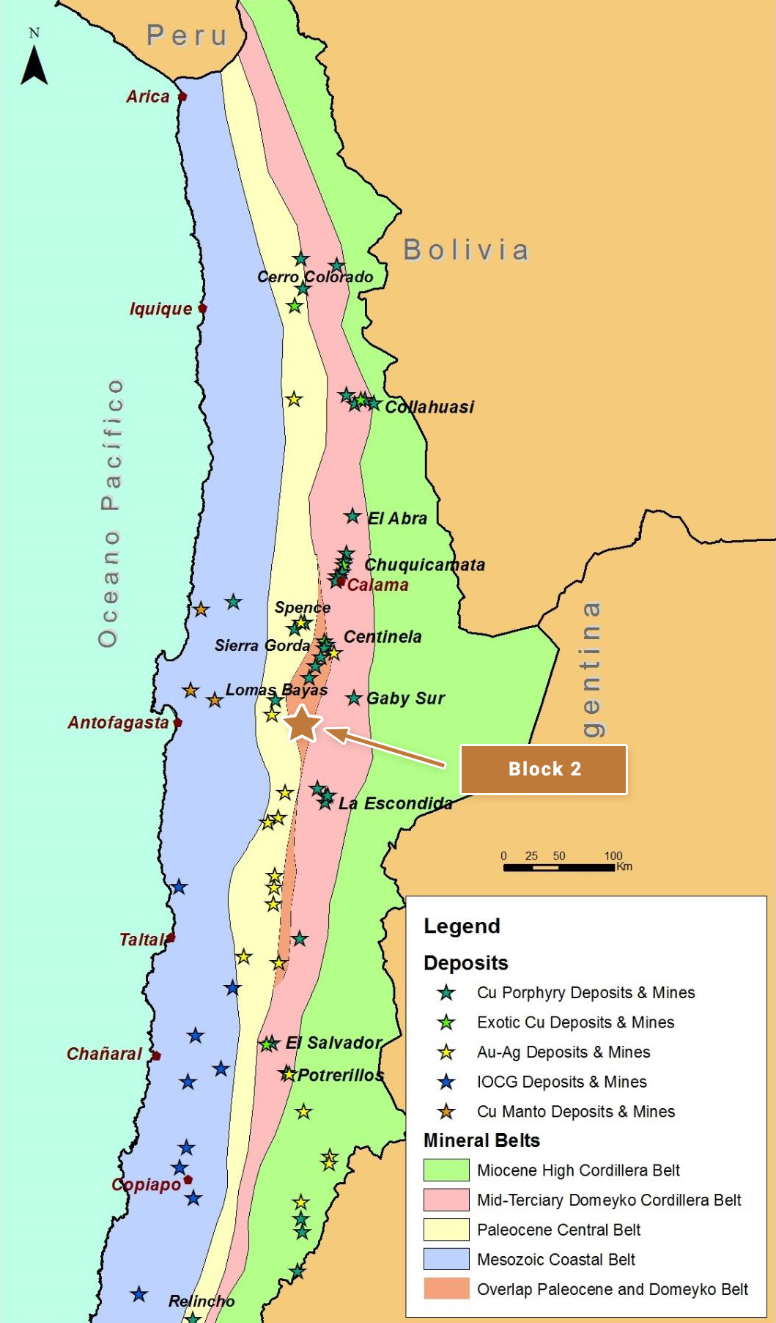
Block 2 is located in northern Chile and is centered approximately 120 km east of the coastal port city of Antofagasta The project is situated along one of the most geologically productive segments of the principal northern Chile copper belt, along trend and approximately 45 km north northwest of the giant La Escondida copper mine and other related copper deposits in the district (BHP Billiton, Rio Tinto, Antofagasta Minerals and Barrick Gold) The reader is cautioned that there is no evidence to date that a comparable mineral resource could be found at Block 2
OWNERSHIP
The Block 2 project area consists of approximately 3 300 Ha of 100 owned tenement comprising both exploration and mining concessions The property is subject to an underlying 1 NSR Royalty on production of all metals.
GEOLOGY AND DEPOSIT TYPE
Block 2 lies along the mid Tertiary porphyry copper belt of northern Chile the Domeyko Cordillera that is host to three of the world’s top five copper mining districts at Collahuasi Chuquicamata and La Escondida (the world’s single largest copper mine)
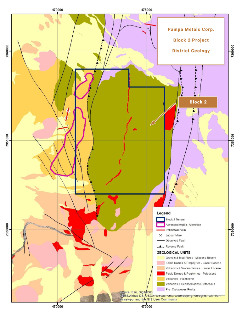
The area of interest at Block 2 is located within an area underlain by Paleocene volcanics and intrusives partially covered by (post mineral) Miocene to Pliocene aged gravels and sediments, and with thrusted blocks of Triassic to Jurassic marine sediments and Cretaceous volcanics along the north eastern and eastern margins Polymetallic veins
appear to be zoned on a district scale around mapped hydrothermal alteration The principal strands of the Domeyko Cordillera fault zone extend approximately north south through the La Escondida mining district, including the Escondida Fault,Fault,(also sometimes referred to as the West Fissure Fault Zone or Falla Oeste) One important fault strand, the Sierra de Varas Fault, passes through the Block 2 area to the east of the principal target, and may link into a post mineral thrust fault that obscures the target
EXPLORATION AND RESULTS TO DATE
Hydrothermal alteration dominated by an advanced argillic zone of quartz alunite, or “ has been mapped over about 3 5 km within volcanic tuffs along an elongate, approximately N S to NE SW oriented ridge of Paleocene aged volcanic rocks (the Los Morros alteration zone), which is surrounded along its western, northern and eastern flanks by chlorite epidote ( hydrothermal alteration in andesitic volcanic rocks Zoned, polymetallic veins, previously mined on a small scale in an artisanal fashion, occur along the western and northern flanks of the lithocap.
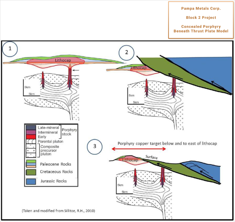
A significant N S trending, westward verging thrust fault has been mapped on the ground and is indicated on published geological maps to the immediate east of the altered outcrops The thrust fault translates older, Cretaceous aged andesitic rocks over the altered Paleocene aged volcanic rocks Revelo geologists propose that the hydrothermal alteration likely extends to the east below the thrust fault, with a possible porphyry copper source to the “ located underneath, and obscured by, the thrusted pre mineral volcanic rocks Another significant N S fault, the Sierra de Varas Fault, lies approximately 5 km to the east and would limit the area in which to search for the covered porphyry system.
INFRASTRUCTURE
Access to the property is from Antofagasta via 120 km of paved road on route towards the La Escondida copper mine and then 33 km of unpaved gravel road Total journey time from Antofagasta is about 3 hours Altitudes vary from approximately 2 400 m to around 2 900 m.
QUALIFIED PERSON
Mario
Orrego G, Geologist, MBA and Qualified Person of the Mining Commission of Chile, an independent consultant, is the Company’s Qualified Person for the purposes of National Instrument 43 101 Standards of Disclosures for Mineral Projects of the Canadian Securities Administrators, and is responsible for the accuracy of, and has verified the technical information in, this project summary, and has approved its written disclosure
BLOCK 2 SUMMARY KEY POINTS
LOCATION
Northern Chile, 120 km ESE of Antofagasta
Centered 45 km NNW of the giant La Escondida Mining District (BHP Billiton & Rio Tinto)
OWNERSHIP
100% Pampa Metals
PROPERTY SIZE
3 300 Ha
DEPOSIT TYPE
Porphyry Copper Au Mo)
STAGE
Early stage post mineral thrust covered exploration target no historic drilling
EXPLORATION PLANS
Geophysical surveying 3 D Vector IP Resistivity with combined Magneto Telluric measurements)
Drill Testing of best anomalies
INFRASTRUCTURE
Moderate access paved roads and unmaintained dirt roads from Antofagasta
Altitude of approximately 2 750 m
Infrastructure possibilities nearby