NUNA NUTAAQ PROJECT
Licence covers historic high-grade gold targets within the Nanortalik Gold Belt and unexplored areas on major structural trends.
OVERVIEW
Nuna Nutaaq, licence 2019/113, comprises 5 sub areas within the Nanortalik Gold Belt and covers all major gold showings and prospective areas identified by AEX’s regional machine learning study. Targets were previously investigated by Crew Gold, NunaMinerals and Goldcorp.
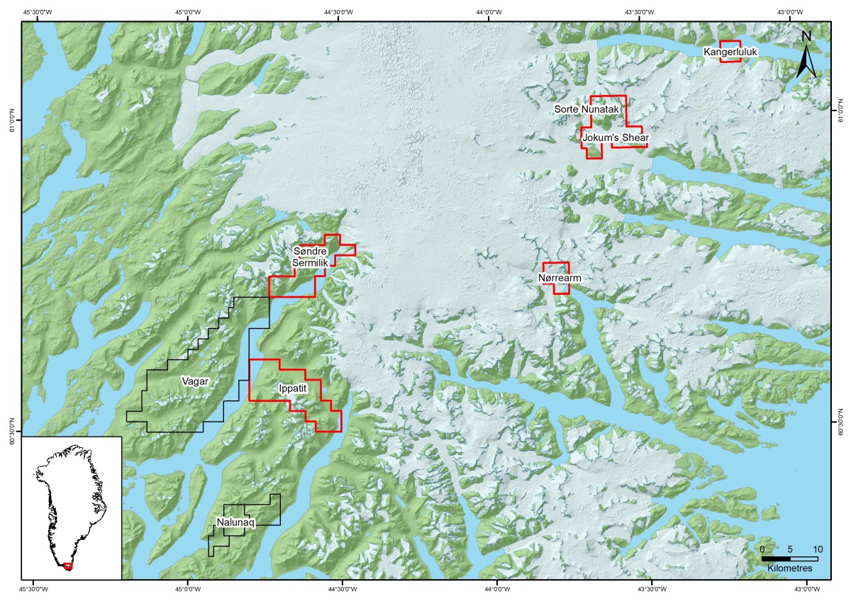
The property lies on the southern side of Kangerluluk Fjord where rocky terrain slopes steeply down to the fjord from an icecap along the southern edge of the licence block at 500-600 m above sea level.
GEOLOGY AND MINERALISATION
The Kangerluluk gold prospect lies at the northern edge of the Psammite Zone of the Ketilidian Mobile Belt and has been mapped and described by Mueller and Stendal (Stendal et al. 1997; Mueller et al. 2000). Supracrustal rocks occur cover an area of about 4 km2 and consist of a 200-300 m thick volcano-sedimentary sequence that rests unconformably on the Julianehåb Batholith.
Gold has been reported in samples from the Kangerluluk property that are closely related to NNE-striking, steeply dipping quartz-bearing shear zones in the supracrustal sequence (Stendal et al., 1997). An alteration halo characterised by silicification and epidotisation is found along these zones. The most prominent shear zone is over 1 km long and up to 20 m wide, cutting across the western side of the mapped area. Gold is associated with copper and only occurs in quartz and zones of hydrothermal alteration that are 2-5 m wide.
Stendal et al. (1997) described three groups of alteration types, each with associated mineralisation:
Group I: syn-volcanic alteration
Alteration is dominated by epidote and relates to extensive, pervasive hydrothermal interaction of seawater with basalts during or shortly after solidification. It is not structurally controlled. Pyrite-pyrrhotite associations formed at this stage, with sulphides disseminated throughout the rock mass. Gold and copper concentrations are low at 20-31 ppb and 35-463 ppm respectively.
Group II: early-stage, post-volcanic alteration
Gold mineralisation in this type of alternation is spatially associated with larger faults and shear zones that cut the supracrustal rocks (Figures 2 and 3) and varies according to the host rock type: quartz veins occur in sedimentary rocks (“quartz-association”) whilst epidote alteration occurs in mafic volcanic rocks (“epidote-association”).
Quartz-association gold mineralisation contains pyrrhotite and pyrite, locally with massive pyrrhotite layers up to 5 cm thick at the contacts of quartz veins. Silicified alteration halos up to 40 cm wide are found along the veins and can contain very high gold grades (e.g. 118 g/t gold in a grab sample). This type of mineralisation is also found in NE-striking shear zones as en echelon sets of quartz veins, 1-2 m wide, 3-10 m long and containing iron sulphides and grades up to 1.15 g/t gold. Stendal et al. (1997) report grades of 7.5 g/t gold over 5 m from chip sampling across one such quartz-rich shear zone.
Epidote-association gold mineralisation is found with pyrite and chalcopyrite mineralisation along ESE- and NNE-trending faults. Grades of 1.1 g/t gold and 1.6% copper over 0.5 m, and 3.3 g/t gold and 1.6% copper have been reported from chip sampling (Stendal et al. 1997).
Group III: late-stage, post-volcanic alteration
The final phase of alteration can be observed as several different types:
- “Bleaching” due to sericitisation of host rocks along ESE- and NNE-trending faults with hairline veinlets of quartz and opaque minerals;
- Calc-silicate alteration comprising garnet, epidote and amphibole recrystallised in former epidote veins of group II alteration. Ore minerals and quartz occur interstitially;
- Copper-gold mineralisation in veinlets, breccias and faults/shears. In pillowed sequences, crosscutting veinlets contain chalcopyrite, bornite and minor chalcocite, and most copper-bearing samples grade 0.1-1.0 g/t gold (and one sample of 6.2 g/t). Some aplites in the batholith have also been altered and contain up to 5 vol% pyrrhotite with associated gold (up to 1.39 g/t);
- Late carbonatization in brittle faults in both supracrustal rocks and the batholith. Haematite, iron and copper sulphides, galena and sphalerite may be found, but this alteration type does not contain gold.
Stendal et al. (1997) propose that gold mineralisation occurred at about 1,800 Ma, around the same times as late phases of emplacement of the Julianehåb Batholith and just after the deposition of the supracrustal volcano-sedimentary sequence. Gold was then concentrated into brittle structures during subsequent deformation, becoming associated with copper sulphides in mafic rocks, and found as native gold with iron sulphides in quartz veins. This remobilisation of gold in the supracrustal rocks may have been aided by heat from emplacement of Rapakivi granites at about 1,740 Ma.
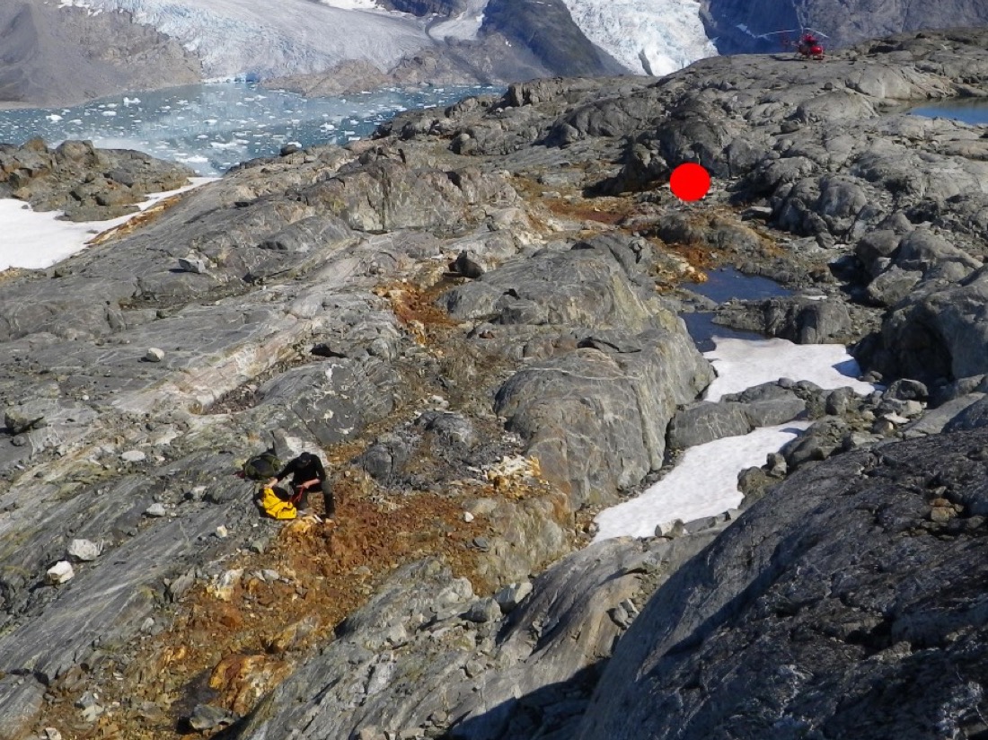 Figure 2:The northern part of the central shear zone looking towards north (Pedersen, 2010). The rusty coloured areas contain massive quartz veining with pronounced sulphide mineralisation surrounded by epidote altered pillow lava. The location of the 118 ppm Au sample is marked with a red dot.
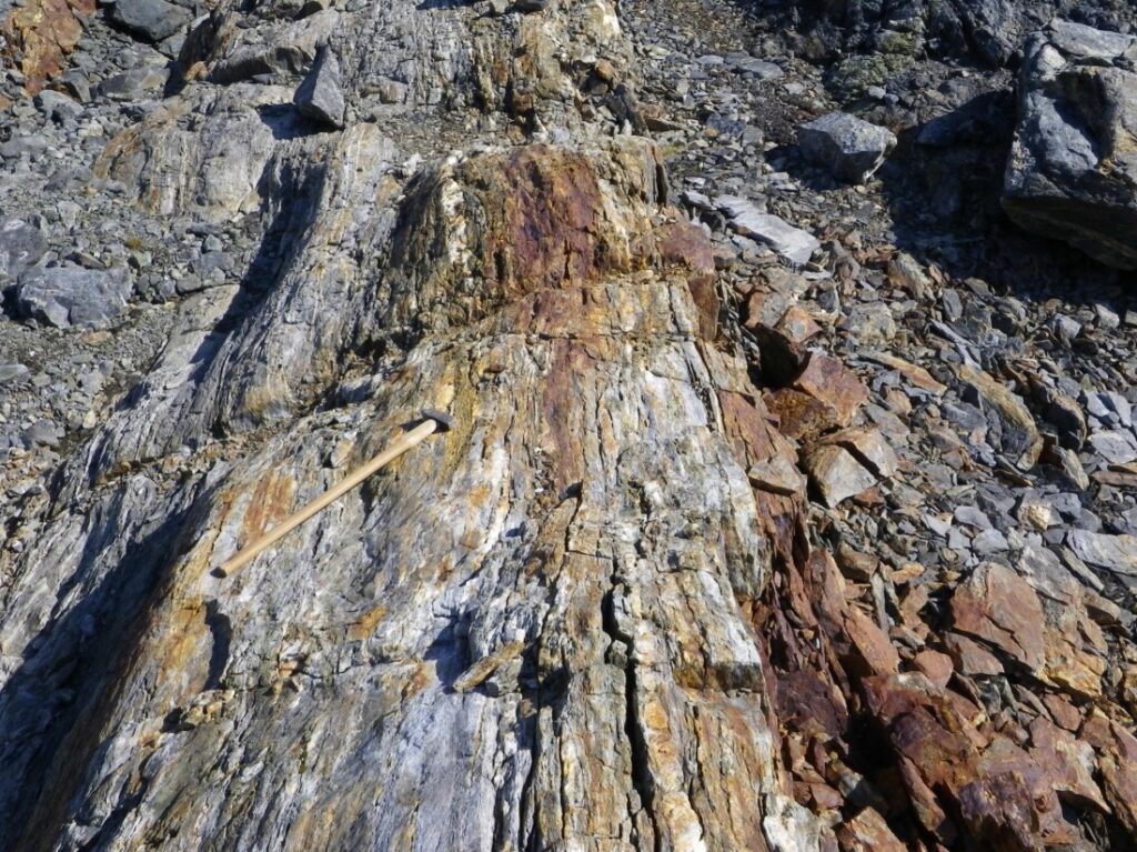 Figure 3:Gold-bearing quartz veins in the main shear zone at Kangerluluk (Hughes et al., 2014). Photographed during NunaMinerals’ exploration in 2010.
EXPLORATION HISTORY
Prospective supracrustal rocks were identified at Kangerluluk in 1992 during the SUPRASYD project (SUPRASYD took place between 1992 and 1996; it was Government-funded and aimed to assess the economic potential of the Ketilidian Mobile Belt via a series of geological, geophysical and geochemical work programmes). Mapping and sampling by GEUS in 1995 and 1996 identified gold mineralisation, reporting grades in grab samples of up to 118 g/t gold, and 12 of 74 grab samples graded over 1 g/t gold (Stendal et al. 1997). These results were announced by GEUS in April 1997 and an exploration licence was granted to Goldcorp Inc. in July of the same year after several competing applications were considered (Sannes, 1998).
Goldcorp Inc. immediately undertook a short programme of reconnaissance, mapping and sampling in August 1997, collecting 112 rock samples of which 105 were from the main mineralised NE-trending shear structure identified by GEUS, including 82 channel samples taken with a diamond rock saw.
It was reported that in the north-eastern third of the shear structure quartz veins were discontinuous and averaged less than 1 m thick (locally up to 2 m). In some places then veins are folded and have extensive dip slope exposures that make them appear much larger than they really are. Widespread rust straining from the weathering of sulphides in the veins and the wallrock also gives a misleading impression of the extent of mineralisation.
The remainder of the shear structure to the southwest reportedly contains much less quartz, occurring as thin sheeted veins or rarely as larger veins and pods of up to 1 m thick. Locally, however, more favourable veining can be found but with very erratic gold grades. Thicker veining, up to 1.5 m, was found in the final 100 m of the shear before it disappeared beneath moraine at the edge of the icecap although grab samples contained no gold.
As may be expected of this style of gold mineralisation, Goldcorp’s sample results include very erratic gold grades (high nugget effect). About a third of their samples were below the detection limit for gold, whilst the average grade for 100 channel and chip samples was about 2 g/t (max. 110 g/t over 80 cm true thickness in one channel sample). If the five highest grade samples were eliminated, the average would be 0.23 g/t gold.
Goldcorp considered the prospect to be intriguing on account of its strong structural setting and acknowledged that the extent of mineralisation at depth and below the icecap was unknown, and that there was potential to improve continuity along strike. However, given the highly erratic nature of mineralisation, the remote location and high cost of further exploration, they decided not to proceed and concentrated on other gold prospects in South Greenland.
In 2010, the Kangerluluk prospect was included in a new exploration licence (number 2010/39) owned by NunaMinerals A/S. They undertook a very short (four day) field programme in August of that year, aiming to follow up and expand on Goldcorp’s work via rock sampling of the shear and fault zones as well as material beyond these in order to improve the geochemical understanding of the area. NunaMinerals took 63 rock samples, 10 of which graded more than 1 g/t gold from a rusty shear zone with massive quartz veins and reported that the mineralised zone was some 20 m wide and more than 700 m long. NunaMinerals also noted that low gold grades (less than 0.2 g/t) were found in pillow lavas along the shear zone, possibly indicating potential to expand the width of prospective material (Pedersen, 2010). They recommended further sampling and structural assessment to increase the understanding of grade continuity and controls on mineralisation.
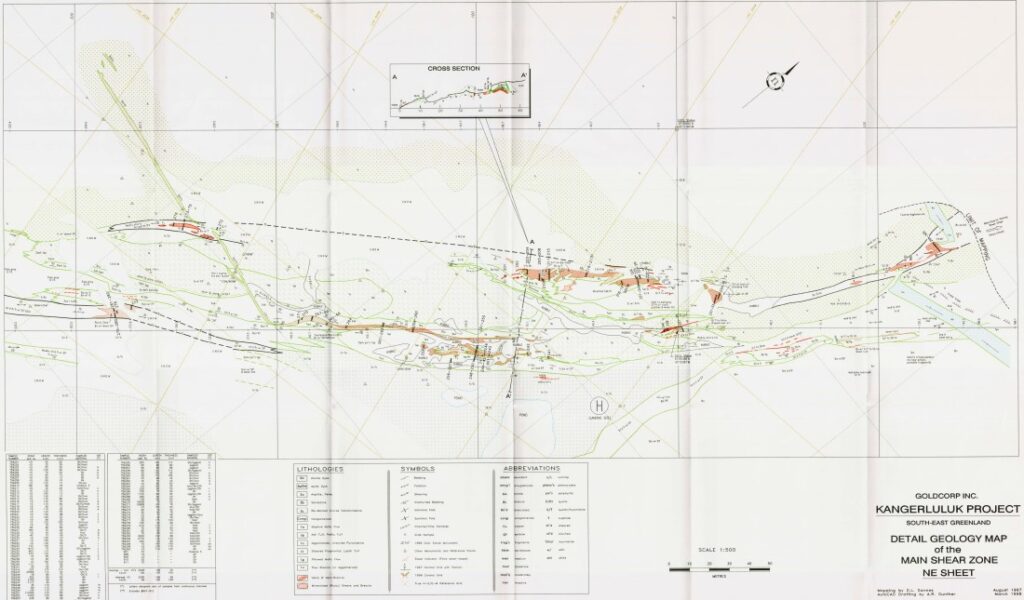 Figure 4: Geological map of the main shear zone, NE section, Kangerluluk, showing Goldcorp channel sample locations (Sannes, 1998)
EXPLORATION POTENTIAL
The Kangerluluk prospect has a relatively well-defined mineralised shear zone with some promising gold grades. It remains open along strike and at depth and has only been lightly explored. Work must now focus on establishing the continuity of mineralisation along and across the structure. AEX plans to carry out structural work and further sampling in the 2020 field season.
References
Blomsterberg, J., 2005: Gold exploration in Niaqornaarsuk Valley, Lake 410 and Ippatit, field season 2004. Nanortalik I/S exploration licence 2004/05.
Garde, A.A., & Schønwandt, H.K. 1994: Project SUPRASYD 1993: granitic rocks and shear zones with possible gold potential, Julianehåb batholith, South Greenland. Rapport Grønlands Geologiske Undersøgelse 160, 28-31.
Garde, A.A., & Schønwandt, H.K. 1995: Project SUPRASYD 1994: Ketilidian supracrustal rocks in South-East Greenland and gold-bearing shear zones in the Julianehåb batholith. Rapport Grønlands Geologiske Undersøgelse 165, 59-63.
Garde A. A., Hamilton M. A., Chadwick B., Grocott J., McCaffrey K. J. W. (2002). The Ketilidian orogen of South Greenland: geochronology, tectonics, magmatism, and fore-arc accretion during Palaeoproterozoic oblique convergence. Canadian Journal of Earth Science 39:765-793
Hughes, J. W., Christiansen, O. Schlatter, D. M. (2014). The Vagar and Hugin Gold Projects, South Greenland. NunaMinerals A/S company presentation
Mueller, W.U., Garde A.A., Stendal, H., 2000: Shallow-water, eruption-fed, mafic pyroclastic deposits along a Paleoproterozoic coastline: Kangerluluk volcano-sedimentary sequence, southeast Greenland. Precambrian Research 101, 163–192
Nielsen, T.D.F., Chadwick, B., Dawes, P.R., Frith, R.A., & Schønwandt, H.K. 1993: Project SUPRASYD 1992: opening season in the Ketilidian of South Greenland. Rapport Grønlands Geologiske Undersøgelse 159, 25-31.
Pedersen 2010: Exploration in the Taateraat Licence 2010/39, 2010. NunaMinerals A/S 2010
Petersen, J. S. & Olsen, H. K., 1995: Gold exploration in Ippatit area – Søndre Sermilik – Amitsoq island, South Greenland. Exploration licence 12/93. Internal report, Nunaoil A/S, 25 pp., 5 app., 6 plates.
Sannes, D.L., 1998: Geological report on the Kangerluluk gold prospect, Southeast Greenland. GoldCorp Inc. pp. 1-57.
Schlatter and Hughes, 2012: Gold exploration in License 2010/39. Fieldwork conducted at Jokum’s Shear within the Hugin Licence during 2012
Steenfelt, A., 2001. Geochemical atlas of Greenland — West and South Greenland. Danmarks og Grønlands Geologiske Undersøgelse Rapport 2001/46 (39 pp., 1 CD-ROM)
Stendal, H., & Schønwandt, H. K. 1997: Project SUPRASYD, South Greenland. Minerals Industry International 1038, 32-37.
Stendal, H., & Schønwandt, H. K. 1997: Project SUPRASYD, South Greenland. Minerals Industry International 1038, 32-37. Swager, C., Chadwick, C., Frisch, T., Garde, A., Schønwandt, H. K., Stendal, H., & Thomassen, B. 1995: Geology of the Lindenow Fjord – Kangerluluk area, South-East Greenland: preliminary results of Suprasyd 1994. Open File Series Grønlands Geologiske Undersøgelse 95/6, 78 pp.