DALE PROPERTY
Dale Property Highlights
- The Dale Property is situated within a stable and developed mining jurisdiction in Canada.
- The Property comprises a contiguous block of 90 claims (4 square kilometers in size, 4171 acres), situated in the northwest part of the Dale Township, Porcupine Mining Division, Ontario Canada.
- The Property is easily accessible by logging roads or lake access.
- Historically the Property has been underexplored. Only recently has several new gold occurrences been discovered while prospecting only a small percentage of the Dale Stock.
- Gold has been found by traditional prospecting which focused on shears and contacts within the Dale Stock where rocks contain weak sulfurization which is associated with +/- chlorite, carbonate, potassic alteration and quartz-carbonate veining.
- Till sampling, alluvial-stream sampling and grab samples have returned highly elevated pristine-modified gold grain counts. Grab samples have returned up to 4 g/t Au from weak shears and veining at locations mostly distant from each other suggesting there might be multiple auriferous locations within the Dale Stock. Its contacts with the mafic volcanic lithologies further suggest both quartz-carbonate vein and disseminated-stockwork hosted gold potential also associated with chalcopyrite and molybdenite.
- Silver has been assayed as high as 1.2 oz/t in narrow massive sulphide veins and up to 6 g/t in porphyry textured rocks near gold bearing weakly altered, mineralized shears. Most recently the silver potential has been recognized and included in laboratory analysis.
- The Property is situated in the Swayze Greenstone Belt, between two high strain zones and the Horwood Fault System transects north-south and centrally through it. Gold has been found at the contact of the mafic volcanic and Dale Stock contacts and the Horwood Lake fault system which is to the north of the Dale Stock.
- The lithologies of the Dale Stock have similarities to other gold occurrences and mines in the Swayze Greenstone Belt (SGB). Recently the Côté Gold Mine Project (situated 45 kilometers south of the Dale Property) announced it is going into production. (Construction Decision Approval announced July 21, 2020, total proven and probable reserves of 4.7 million ounces. 69% of total reserve ounces are in the Proven category. Total measured and indicated resources of 6.5 million ounces, total inferred resources of 1.6 million ounces, average grade 0.5 g/t).
- The Element79 team has completed its 2020 required investment in advancing the work on the Dale property to include drone-flyover Magnetic Resonance scanning and analysis. This analysis will better help Element79 with strategizing best regions to spend further time and energy exploring, as well as potential additional land acquisitions adjacent to the property.
About The Dale Property
History
The Dale Property was acquired on June 1, 2012 by ground staking (Ontario Gazette) after the Algoma-Talisman’s appeal failed in December 2010, reverting several townships back to the crown. Due to the history of the land tenure, Dale Township was privately held and unavailable for conventional staking and prospecting.
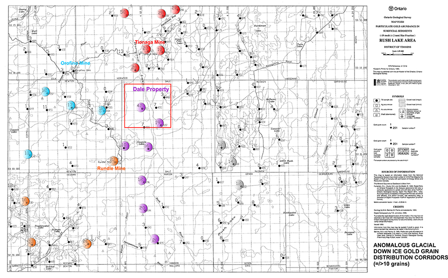
The area was staked due to its structural and regional relationships with other gold occurrences and an anomalous gold in till, down ice glacial outwash leading back to the Dale Stock. Other anomalous gold in glacial till outwash lead back to historic gold mines supporting the potential of undiscovered gold potential in the Dale Stock.
The Dale Township itself was first acquired by Algoma-Talisman as part of the Algoma Eastern Railway. Prior to the Dale and other townships reverting to the Crown. Placer Dome Canada Limited (PDCL) completed the most extensive exploration program in Dale Township to date, which included an airborne magnetic-electromagnetic (EM) survey, followed with a ground campaign.
The 2019 Induced Polarization intermediate gradient survey completed within the shoreline of Horwood Lake, over the ice, corresponds very well with PDCL weak EM anomalies.
Since acquiring the Dale Property, the claim holders were prospecting on a limited budget, for short periods of time, taking samples from prospective locations distant from each site, of which on every occasion, assays returned anomalous to highly anomalous gold.
Recent ground truthing of 4 of 21 of the strongest induced polarization intermediate gradient survey anomalies have returned >0.5 to 4 g/t Au, taken from the first available mineralized outcrop to the anomalous IP anomaly. The location of the 4 g/t sample has been measured to approximately 10 meters in width with an undetermined strike length. In the same location numerous similar mineralized rocks, from an apparent close source, in an up-ice direction suggest an undiscovered auriferous zone. A duplicate till sample taken by the claim holders 10 meters from a highly anomalous gold in till sample taken by Ontario Geological Survey (OGS) regional till sampling program in the 1980s, resulted in increasing the gold grains from 42 (OGS sample) to 114 gold grains (Overburden Drilling Management). 95% of the gold grains in this sample were pristine to modified suggesting a local source from within the Dale Stock. There are also indications of base metals in the northeast sector of the Dale Property.
Regional Setting and Mineralization
The Swayze Greenstone Belt
The Swayze Greenstone Belt is bounded to the west by the Kapuskasing structural zone and by the Nat River granitoid complex to the north, the Kenogamissi batholithic complex to the east, and the Ramsey-Algoma granitoid complex to the south. Volcanic and sedimentary rocks range in age from 2731 to 2690 Ma (Dale Stock 2680 Ma), whereas the intrusive rocks range in age from 2740 to 2660 Ma. The volcanic and sedimentary rocks form an upward-facing, upward-younging stratigraphic sequence that is complexly folded and faulted.
The Swayze Greenstone Belt (SGB) north and south parts have undergone a considerable amount of mineral exploration since the turn of the century, with peaks of prospecting activity in the 1900s, 1930s, and from the mid 1940s to the present time. Early exploration in the area was concentrated on iron and gold (Harding 1937). Gold mineralization was discovered at the Joburke Mine in Keith Township in 1946. This find resulted in an increase in gold exploration (Prest 1951) which has continued to the present. Other past producing gold mines in the SGB with similar lithologies to the Dale Stock include the Jerome Gold Mine, Halcrow Swayze Mine, Kenty Gold Mine, Rundal Mine, Orogino Mine, and the Tionaga Mine.
Other economic commodities discovered in the SGB include nickel, copper, zinc, silver, lead, cobalt, manganese, iron, asbestos, barite, talc, and silica.
Down Ice Distribution of Anomalous Gold Grains
Map P2234 by the Ontario Geological Survey (OGS) shows the down ice distribution of anomalous gold grains. Note the patterns of elevated gold grains in till south of known gold deposits and compared to the Dale Stock. It could be interpreted that an undiscovered source of gold exists within the Dale Stock that has created the anomalous gold in till samples in a down ice direction. The till sample that twinned the OGS sample was taken at two depths. The upper layer contained rounded material suggesting a distal source. The lower sample taken below 30 to 60 centimeters contained angular fragments of the same rock locally and no rounded material suggesting a source derived from the Dale Stock.