MORROS BLANCOS
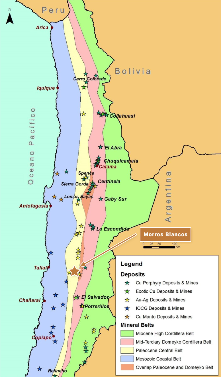
Morros Blancos is located in northern Chile approximately 75 km east-southeast of the coastal city of Taltal, and in a similar geological setting to, and approximately 320 km south-southwest of, the Spence (BHP) and Sierra Gorda (KGHM & Sumitomo) copper mines, and immediately east of the Amancaya gold-silver mine and close to the Guanaco gold-silver mine. The reader is cautioned that there is no evidence to date that a comparable mineral resource could be found at Morros Blancos.
OWNERSHIP
The Morros Blancos project area consists of approximately 7,300 Ha of 100% owned tenement comprising both exploration and mining concessions.
The property is subject to underlying NSR royalties totalling 3% on base metals and 2% on precious metals, with a buy-back clause that can reduce royalties to 2% on base metals and 1% on precious metals for a payment of US$5 million, at any time.
GEOLOGY AND DEPOSIT TYPE
Morros Blancos lies within the Paleocene volcanic belt of northern Chile that hosts a series of important porphyry copper deposits and mines, such as Cerro Colorado (BHP), Spence (BHP), Sierra Gorda (KGHM & Sumitomo) and Relincho (part of Nueva Union – Teck-Goldcorp).
The property is also situated immediately east of the Amancaya gold-silver mine (Austral Gold), which exploits high-grade, low-sulphidation, epithermal gold and silver veins.
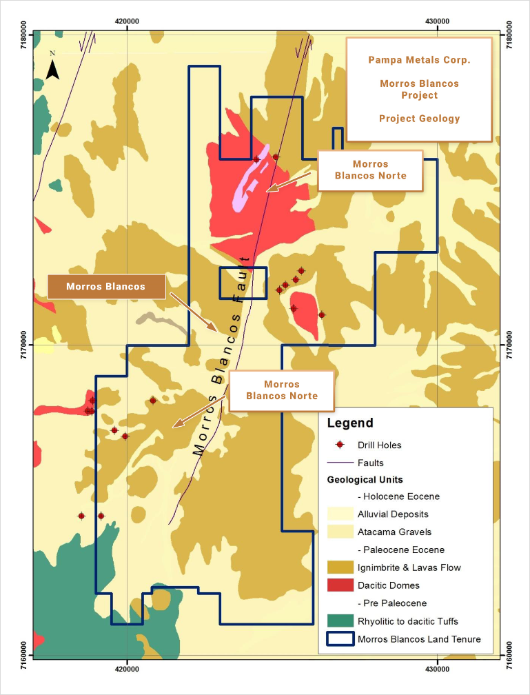
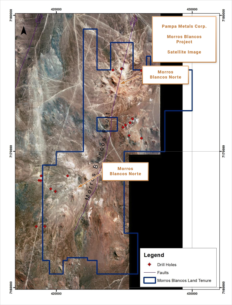
Morros Blancos comprises two large hydrothermal alteration systems – Morros Blancos Norte (MBN) and Morros Blancos Sur (MBS) – characterised by widespread zones of advanced argillic alteration (quartz-alunite-dickite-pyrophyllite-kaolinite), multi-element geochemical anomalies, and zones of quartz veinlet stock-working (at Morros Blancos Sur), which have potential for high-sulphidation copper-gold-silver mineralisation, as well as porphyry copper (+/- Au +/-Mo) mineralisation at depth.
EXPLORATION AND RESULTS TO DATE
The hydrothermal alteration is hosted within andesitic to dacitic volcanics, with possible quartz-eye porphyry intrusions observed. Both MBN and MBS represent zones of extensive advanced argillic alteration or “lithocaps”, dominated by intense quartz-alunite alteration within larger areas of quartz-alunite-dickite-pyrophyllite and kaolinite alteration. High-temperature alunite (K-alunite) and high-temperature kaolinite (WX¬kaolinite) tend to be focused and are generally coincident with the best geochemical anomalies at surface. Hydrothermal alteration mineralogy and zonation patterns, including high-temperature minerals, combined with multi-element geochemical anomalies from extensive historic and more recent sieved surface geochemical sampling surveys, including Mo and Bi, define central target areas at both Morros Blancos Norte and Sur. Morros Blancos Sur also displays silica flooding and a quartz-veinlet stockwork partially exposed at surface.
Limited, peripheral historic drilling (2,730 m) shows propylitic and sericitic alteration at depth at both target areas. “B” veinlets with molybdenite have been identified in limited drilling to the west of the Morros Blancos Sur target.
INFRASTRUCTURE
Morros Blancos is easily accessed, being located within a short driving distance from the Pan-American Highway along a well-maintained dirt road, some 3 hours’ drive from Antofagasta and 1 hour from Taltal, via the Estacion Agua Verde. A new high-tension power line has been installed along the boundary of the property. The property is situated at modest altitudes ranging from around 1,900 m to 2,100 m.
QUALIFIED PERSON
Mario
Orrego G, Geologist, MBA and Qualified Person of the Mining Commission of Chile, an independent consultant, is the Company’s Qualified Person for the purposes of National Instrument 43 101 Standards of Disclosures for Mineral Projects of the Canadian Securities Administrators, and is responsible for the accuracy of, and has verified the technical information in, this project summary, and has approved its written disclosure.
MORROS BLANCOS SUMMARY KEY POINTS
LOCATION
Northern Chile, 75 km ESE of Taltal
320 km SSW of Sierra Gorda (KGHM Sumitomo) and Spence (BHPB)
OWNERSHIP
100% Pampa Metals
PROPERTY SIZE
~ 7,300 Ha
DEPOSIT TYPE
Porphyry Copper (+/- Au +/- Mo) & High-Sulphidation Epithermal Copper-Gold-Silver
STAGE
Early stage, partially outcropping porphyry and epithermal targets with shallow post mineral cover
geochemical anomalies minor, peripheral historic drilling
EXPLORATION PLANS
Geophysical surveying 3 D Vector IP Resistivity with combined Magneto Telluric measurements, and improved Ground Magnetics Surveys)
Drill Testing of best anomalies
INFRASTRUCTURE
Easy access close to Pan American Highway
Moderate altitudes of around 2 100 m