CERRO BUENOS AIRES
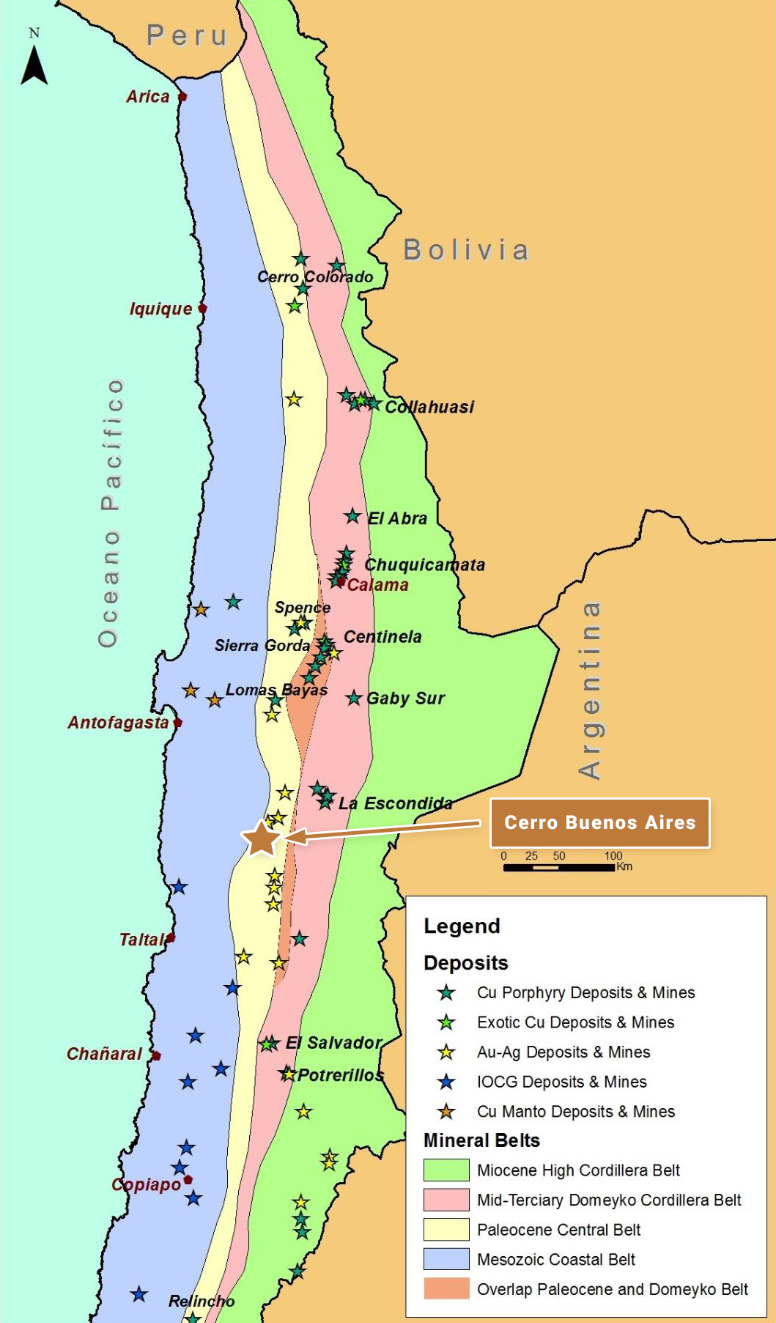
Cerro Buenos Aires is located in northern Chile approximately 130 km southeast of the coastal port city of Antofagasta, and in a similar geological setting to, and approximately 200 km south-southwest of, the Spence (BHP) and Sierra Gorda (KGHM & Sumitomo) copper mines, and close to and along trend from both the El Peñon and Guanaco gold-silver mines. The reader is cautioned that there is no evidence to date that a comparable mineral resource could be found at Cerro Buenos Aires.
OWNERSHIP
The Cerro Buenos Aires project area consists of approximately 7,600 Ha of 100% owned tenement comprising both exploration and mining concessions.
The property is subject to an underlying 2% NSR Royalty on production of all metals.
GEOLOGY AND DEPOSIT TYPE
Cerro Buenos Aires lies within the Paleocene volcanic belt of northern Chile that hosts a series of important porphyry copper deposits and mines, such as Cerro Colorado (BHP), Spence (BHP), Sierra Gorda (KGHM & Sumitomo) and Relincho (part of Nueva Union – Teck-Goldcorp).
The property is also situated along trend and approximately 40 km to the southwest of the important El Peñon and Fortuna mines (Yamana Gold), which exploit a series of high-grade, low-sulphidation, epithermal gold and silver veins associated with the Dominador Fault Zone.
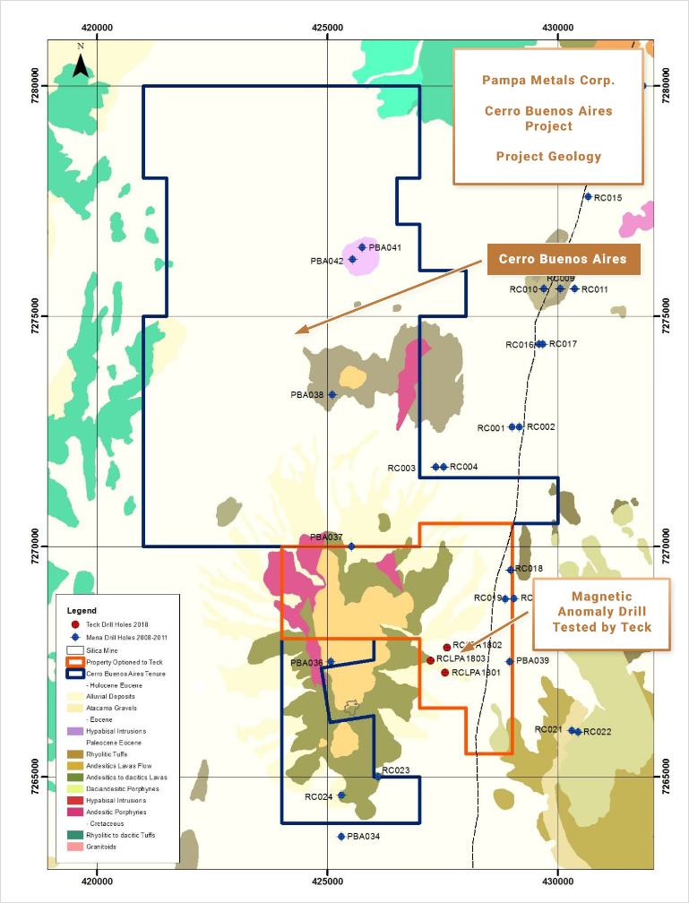
Cerro Buenos Aires consists consists of a series of large outcrops, dominated by the Cerro Buenos Aires hill, displaying characteristics of the upper portions of porphyry copper systems and possibly high-sulphidation precious metals systems, surrounded by extensive pampas filled with post-mineral gravels and mud flows.
A key N-S splay to a regional fault system, the Dominador Fault, continues along the eastern margins of the property.
EXPLORATION AND RESULTS TO DATE
Hydrothermal alteration at Cerro Buenos Aires is dominated by a core of quartz-alunite alteration, with pyrophyllite at lower elevations and in limited drilling, and argillic alteration assemblages along the flanks of the most intense alteration. Alunite, pyrophyllite, dickite, kaolinite and illite-smectite alteration assemblages have been identified by Terrapsec SWIR mineral analyses on rocks and soils.
Intense silicification is widespread and, at Cerro Buenos Aires hill itself, affects a rhyolite dome complex with associated carapace breccias, intruding and intercalated with an andesitic to dacitic volcanic sequence.
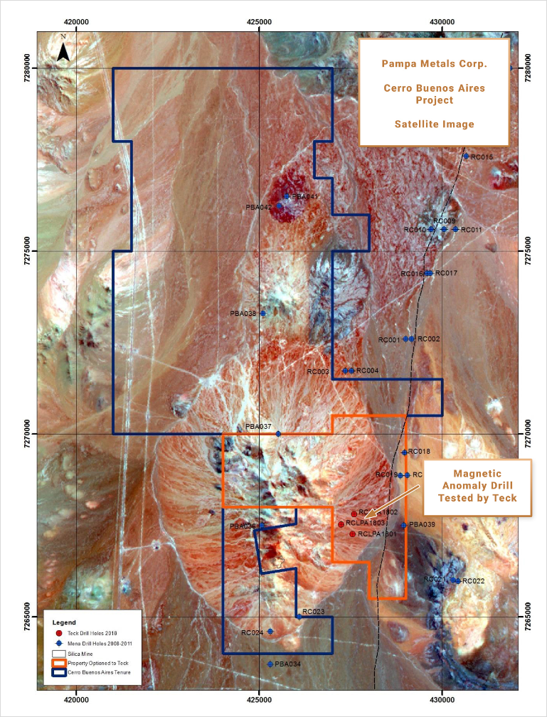
Heli-borne magnetics and TEM data show significant areas of magnetite-destructive alteration associated with the advanced argillic alteration, as well as a series of magnetic highs, some of which could be associated with hypogene porphyry copper centers.
Limited historic drilling (2,856 m – 10 RC holes) along the trend from Cerro Buenos Aires to another outcrop at Cerro Turmalina, carried out in two campaigns (2008 and 2011), cut extensive zones of hydrothermal alteration with sporadic, low-tenor intercepts of gold and silver. More recently, Teck tested a magnetic high as a potential porphyry copper center. 3 drill holes to about 300m depth cut around 80m of post-mineral gravels followed by sericitic alteration in volcanic sequences. Deeper drilling is required.
INFRASTRUCTURE
Cerro Buenos Aires is easily accessed, being located alongside the Pan-American Highway some 2.5 hours’ drive from either the port cities of Antofagasta or Taltal. A new high-tension power line has been installed alongside the main road. The property is situated at modest altitudes of 1,600 m to 2,200 m.
QUALIFIED PERSON
Mario
Orrego G, Geologist, MBA and Qualified Person of the Mining Commission of Chile, an independent consultant, is the Company’s Qualified Person for the purposes of National Instrument 43 101 Standards of Disclosures for Mineral Projects of the Canadian Securities Administrators, and is responsible for the accuracy of, and has verified the technical information in, this project summary, and has approved its written disclosure.
CERRO BUENOS AIRES SUMMARY KEY POINTS
LOCATION
Northern Chile, 130 km SE of Antofagasta
200 km SSW of Sierra Gorda (KGHM Sumitomo) and Spence (BHPB)
OWNERSHIP
100% Pampa Metals
PROPERTY SIZE
~ 7,600 Ha
DEPOSIT TYPE
Porphyry Copper (+/- Au +/- Mo) & High-Sulphidation Epithermal Copper-Gold-Silver
STAGE
Early stage, partially outcropping porphyry and epithermal targets with post mineral gravel covered ( extensions geochemical and geophysical anomalies limited historic drilling
EXPLORATION PLANS
Geophysical surveying 3 D Vector IP Resistivity with combined Magneto Telluric measurements,and improved Ground Magnetics Surveys)
Drill Testing of best anomalies
INFRASTRUCTURE
Easy access alongside Pan American Highway
Moderate altitudes of around 1 900 m