DESTINY PROJECT

Transformative Acquisition
- Option to acquire 100%.
- Located in the historic, mineral rich Abitibi Greenstone Belt.
- Gold mineralization occurs in high-grade quartz veins within shear zones starting at 15m below surface
- Drilling results include:
- 167 g/t Au over 1 m (from 221.7 m)
- 6.15 g/t Au over 23.6 m (from 117.2 m)
- 19.49 g/t Au over 2.7m (from 166.0 m)
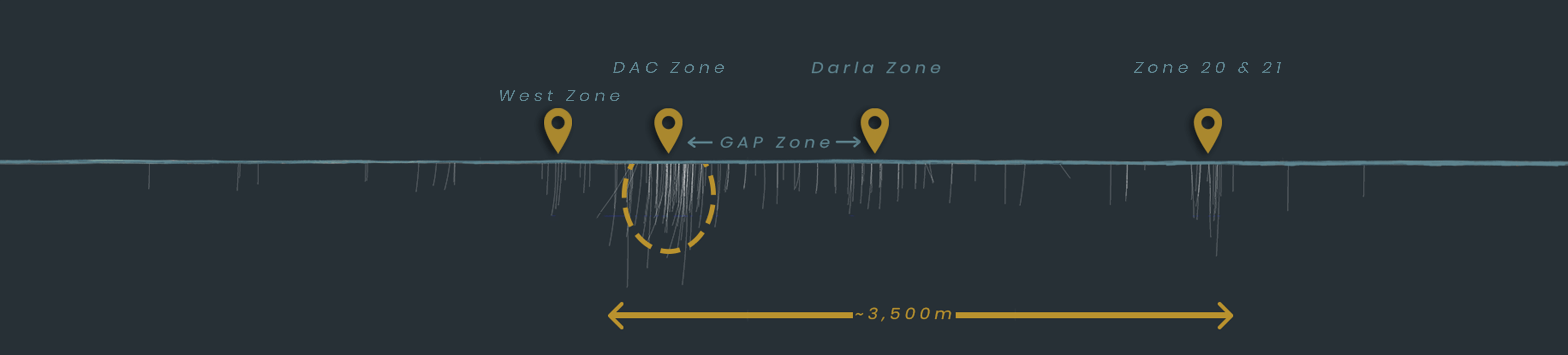
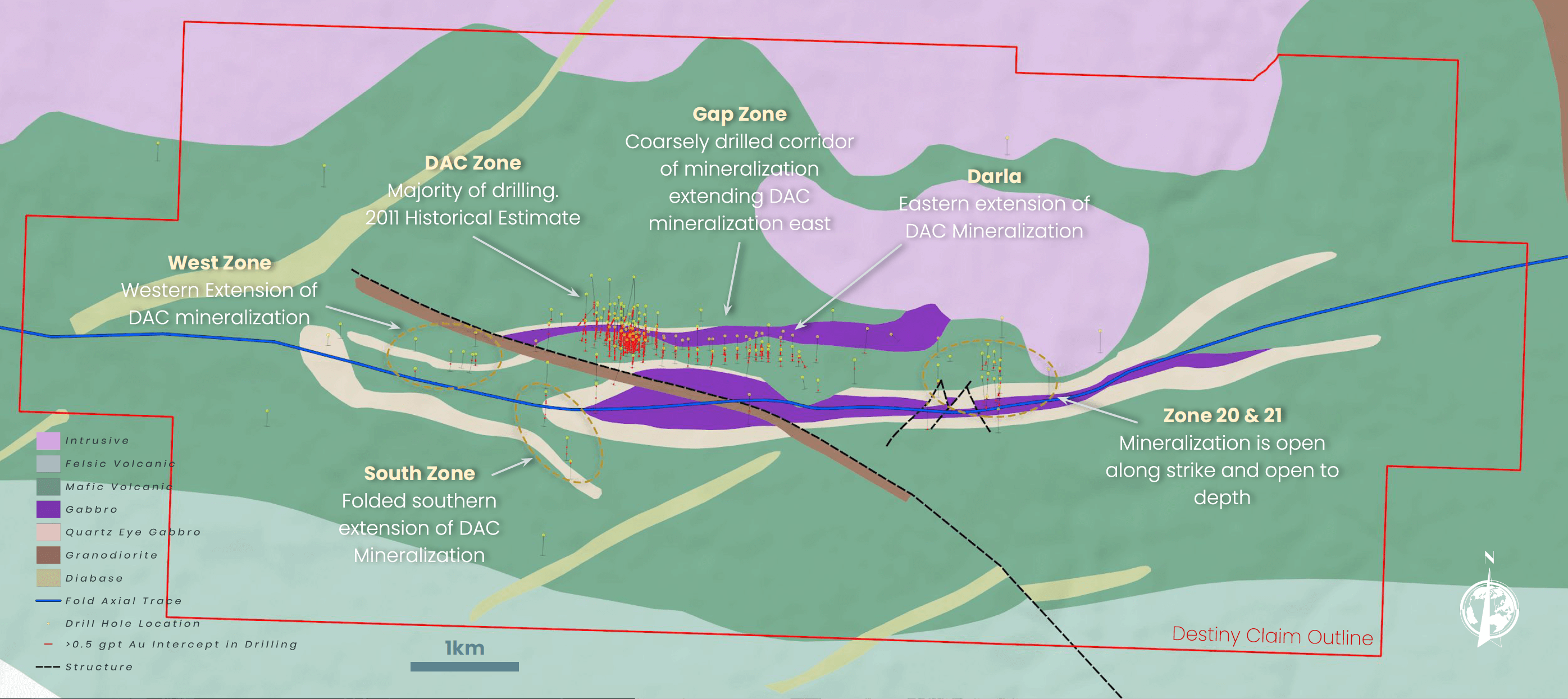
- The Historical Estimate at the DAC Zone is open along strike with only coarse drilling denoting high grade intercepts outside of the 2011 Historical Estimate area showing expansion potential along strike from the DAC Zone over approximately 2.5 km to the Darla Zone
- Excellent infrastructure – ~75 km NNE of Val d’Or with road access
- Considerable work done historically including over 50,000 m of diamond drilling
Mineral Rich
Abitibi Region
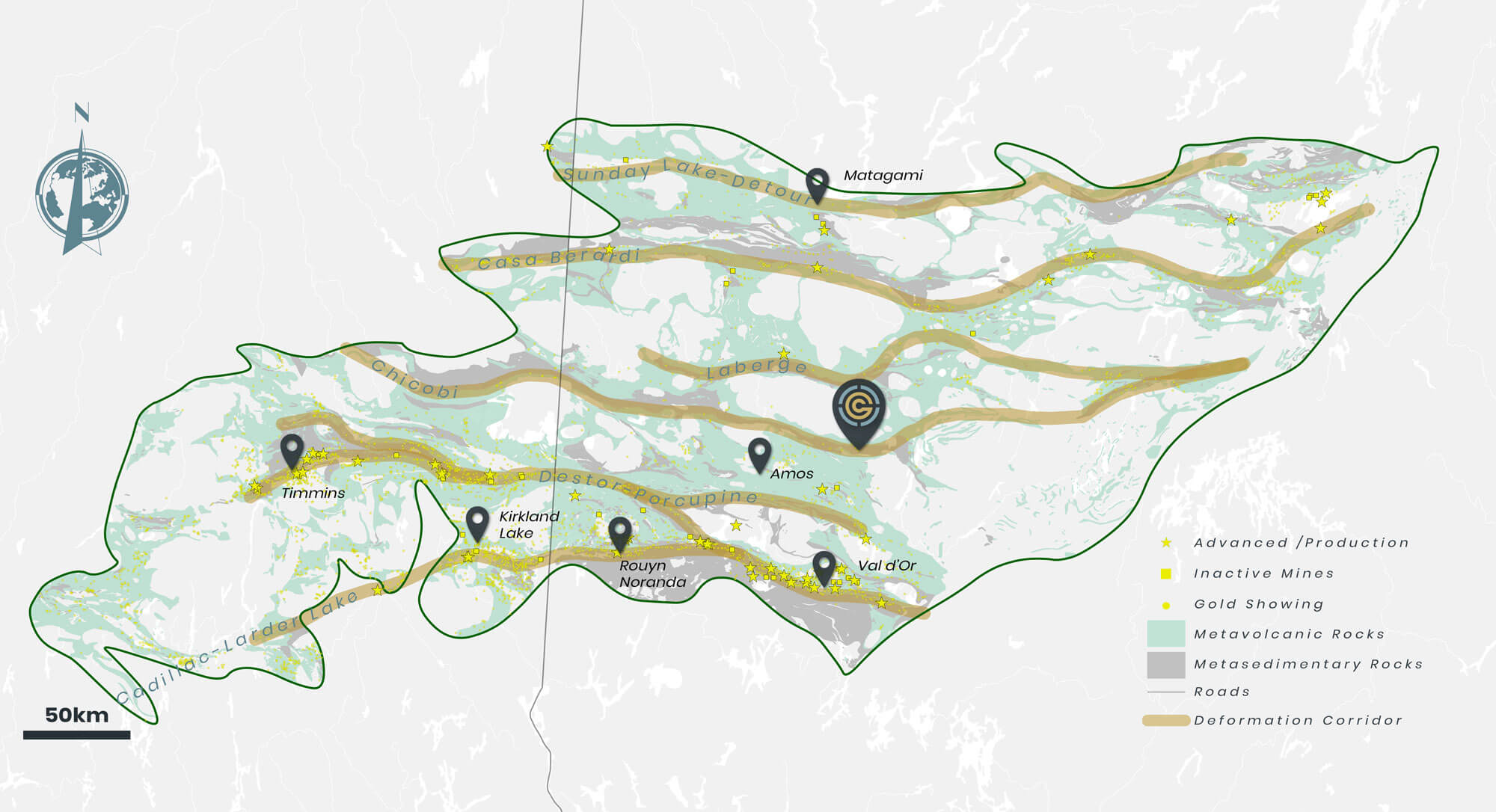
The most famous greenstone belt in the Superior terrane is known as the “Abitibi”
The belt, which spans the Quebec-Ontario border, has produced up to180 million oz. gold from mining dating back to 1901 along major structural breaks within the assemblage of Archean-age volcanic, sedimentary and intrusive rocks.
Exploring
Amongst Giants
Since gold was first discovered in the late 1800’s, the Abitibi has seen exploration radiate along the Cadillac-Larder Lake and Destor-Porcupine deformation zones.
Exploration and discovery has expanded north to other major structural breaks within the region including the Chicobi where the Destiny Project is located.
Exploration
Undercover
The majority of operating mines and significant gold occurrences in the Abitibi occur where there is minimal overburden cover. Exploration is easier at surface. Over the last few decades exploration strategies have adapted to begin looking for deposits undercover.
By compiling available drill hole data we can visualize the concentration of known deposits and showings and observe they largely occur where overburden is thin.
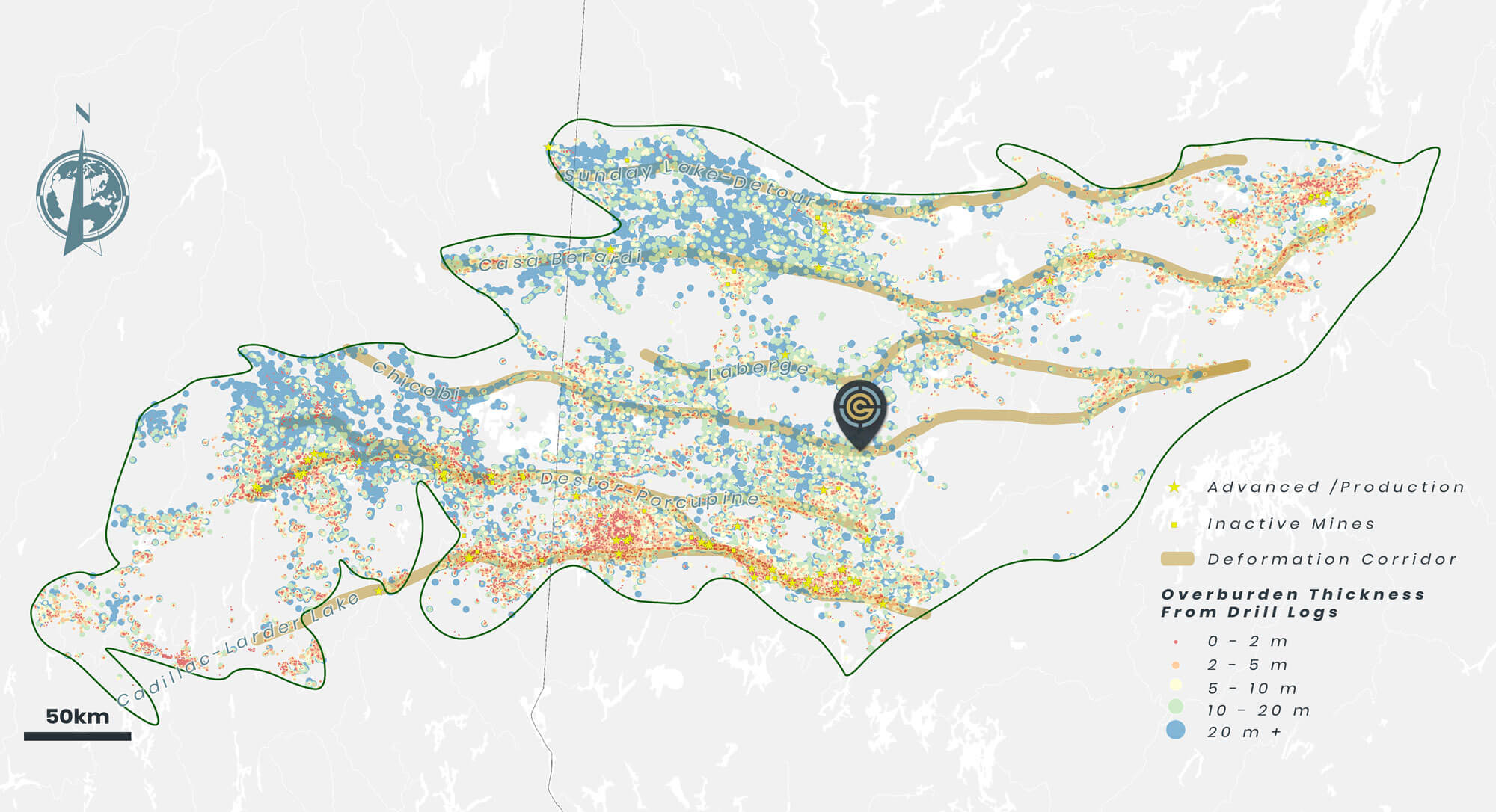 Exploration Undercover
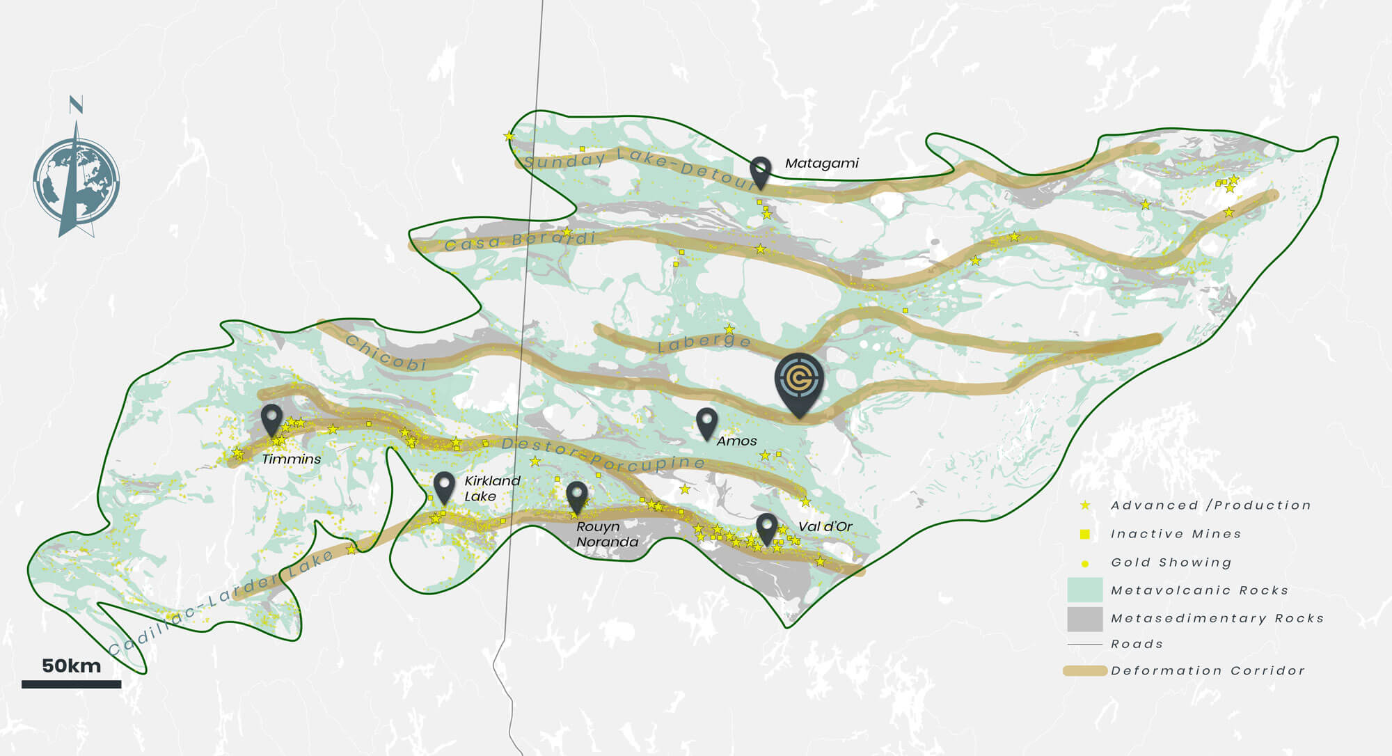 Mineral Rich Abitibi Region
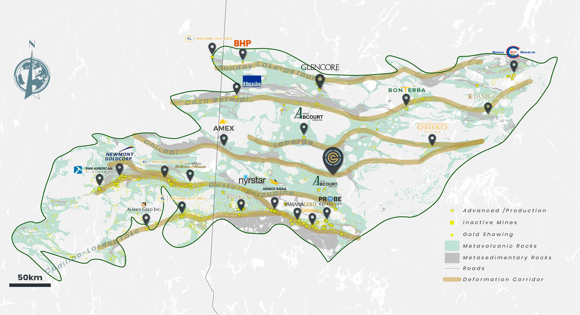 Exploring Amongst Giants
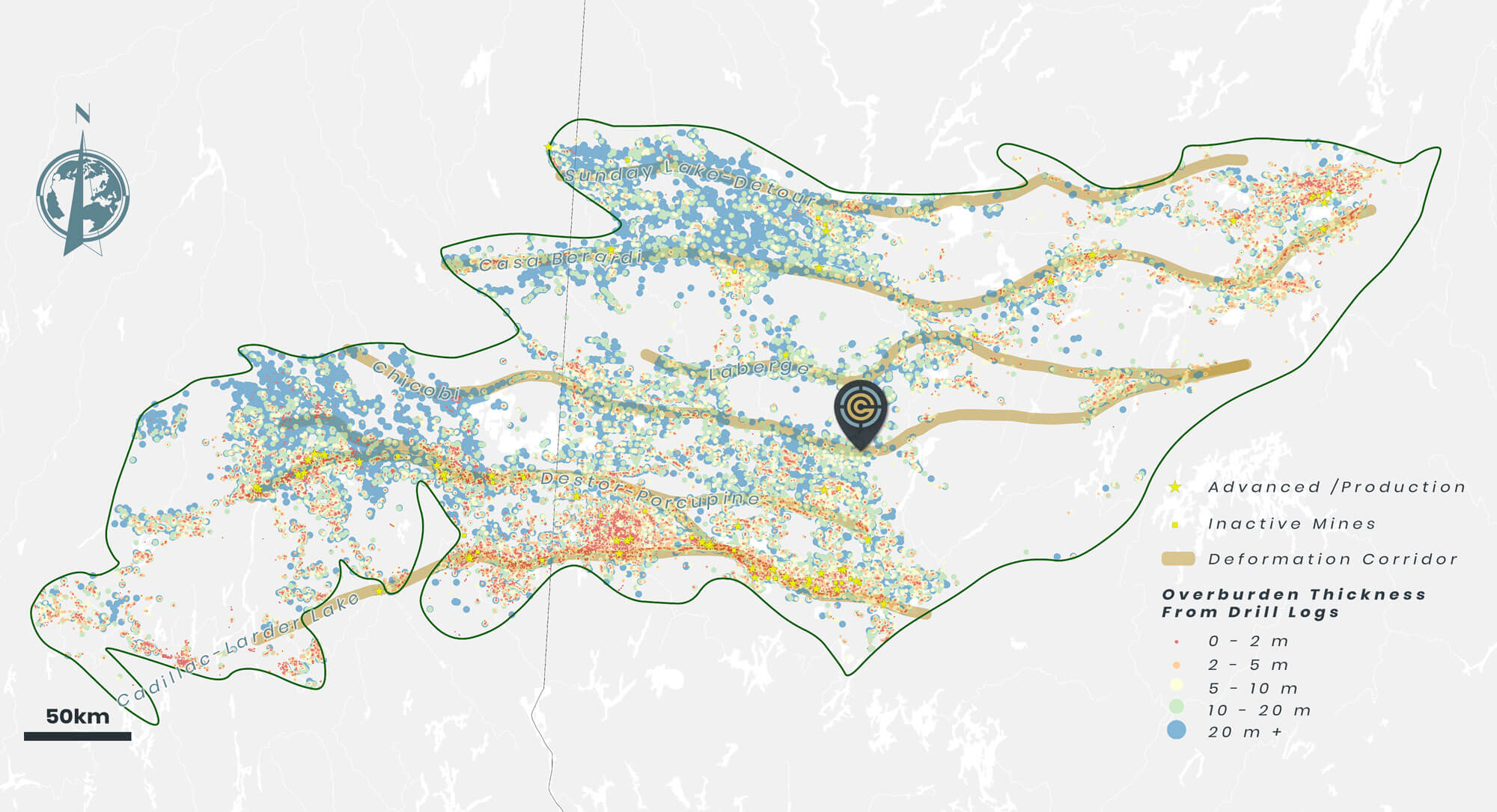 Exploration Undercover
 Mineral Rich Abitibi Region
Previous
Next
Sizable • High Grade Address • Strong Infrastructure • Significant Work to Date
- 5,013 ha
- Road Access ~75 km NNE of Val d’Or
- Exploration of the Destiny Project dates back to the 1930s with the first serious diamond drilling campaign commencing in 1998 by Cameco
- Previous work on the property includes:
- 172 Diamond drill holes comprising > 50,000 m
- Reconnaissance till sampling from 11 Sonic drill holes
- 2,430 MMI geochemical samples
- 982 line km of airborne VTEM surveys
- 171 line km of ground magnetics surveys
- 128 line km of IP

Open For Expansion
West Zone
No. Holes: 7
Deepest Hole: 176 m
Avg. Hole Depth: 134 m
Results include:
-3.36 g/t Au over 0.7 m
-1.5 g/t Au over 1.5 m
DAC Zone
No. Holes: 77
Deepest Hole: 707 m
Avg. Hole Depth: 275 m
Results include:
-6.15 g/t Au over 23.6 m
-19.49 g/t Au over 2.7 m
-167 g/t over 1.0 m
2011 Historical Estimate
Gap Zone
No. Holes: 19
Deepest Hole: 360 m
Avg. Hole Depth: 170 m
Results include:
-12.2 g/t Au over 8.0 m
-16.10 g/t Au over 6.0 m
-90.0 g/t over 1.0 m
Darla Zone
No. Holes: 23
Deepest Hole: 255 m
Avg. Hole Depth: 150 m
Results include:
-6.7 g/t Au over 2.5 m
(incl. 19.73 g/t Au over 0.7 m)
-19.5 g/t Au over 2.1 m
Zone 20
No. Holes: 7
Deepest Hole: 320 m
Avg. Hole Depth: 255 m
Results Include:
4.6 g/t Au over 2.0 m
Zone 21
No. Holes: 8
Deepest Hole: 520 m
Avg. Hole Depth: 265 m
Results include:
2.4 g/t Au over 6.0 m
Drill Hole Summary
Scroll ↔
| Zone | Hole ID | From (m) | To (m) | Interval (m) | Au g/t | Coordinates | Azimuth | Dip |
|---|---|---|---|---|---|---|---|---|
| DAC | DES9917 | 117.2 | 140.8 | 23.6 | 6.15 | 317511mE, 5401669mN | 180.00 | -52.00 |
| including | 118.8 | 121.9 | 3.1 | 23.95 | ||||
| and | 134.8 | 138.5 | 3.7 | 12.46 | ||||
| DES0032 | 159.9 | 169.2 | 9.3 | 3.98 | 317609mE, 5401734mN | 181.50 | -48.0 | -48.0 |
| including | 161.2 | 165.9 | 4.7 | 5.37 | ||||
| and | 163.3 | 165.9 | 2.6 | 7.78 | ||||
| DES05-64 | 161.8 | 170.5 | 8.7 | 5.42 | 317480mE, 5401715mN | 180.00 | -50.00 | -50.00 |
| including | 161.8 | 163.2 | 1.4 | 22.14 | ||||
| DES05-66 | 130.3 | 133.1 | 2.8 | 5.18 | 317451mE, 5401703mN | 180.00 | -50.00 | -50.00 |
| and | 138.3 | 139.3 | 1 | 3.37 | ||||
| and | 142.2 | 143.6 | 1.4 | 8.83 | ||||
| DES05-67 | 163.7 | 170.9 | 7.2 | 8.81 | 317506mE, 5401712mN | 180.00 | -50.00 | -50.00 |
| including | 166 | 168.7 | 2.7 | 19.49 | ||||
| DES05-79 | 130.6 | 133.1 | 2.5 | 10.7 | 317535mE, 5401679mN | 180.00 | -50.00 | -50.00 |
| and | 142 | 145 | 3 | 5.04 | ||||
| DES05-81 | 323.7 | 325.8 | 2.1 | 3.41 | 317515mE, 5401886mN | 185.00 | -50.00 | -50.00 |
| and | 333.7 | 339 | 5.3 | 4.01 | ||||
| including | 333.7 | 338.5 | 4.8 | 4.32 | ||||
| DES06-85 | 214 | 216.5 | 2.5 | 4.31 | 317435mE, 5401793mN | 180.00 | -50.00 | -50.00 |
| and | 221.7 | 222.7 | 1 | 167 * Fig. 1 | ||||
| DES06-96 | 254.4 | 261.2 | 6.8 | 2.46 | 317514mE, 5401770mN | 180.00 | -67.00 | -67.00 |
| and | 272.7 | 275.7 | 3 | 3.04 | ||||
| DES10-137 | 372.9 | 374 | 1.1 | 25.65 | 317605mE, 5401824mN | 180.00 | -50.00 | -50.00 |
| Darla | DES06-91 | 115.1 | 117.2 | 1.2 | 19.67 | 318563mE, 5401542mN | 180.00 | -50.00 |
| DES08-104 | 104.5 | 107 | 2.5 | 6.73 | 318563mE, 5401603mN | 180.00 | -55.00 | -55.00 |
| including | 104.5 | 105.2 | 0.7 | 19.73 | ||||
| Gap | DES12-147 | 85.5 | 91.5 | 6 | 16.1 | 318260mE, 5401550mN | 180.00 | -50.00 |
| including | 87.5 | 88.5 | 1 | 90.3 | ||||
| and | 146 | 148 | 2 | 2.55 | ||||
| West | DES05-75 | 79.8 | 80.5 | 0.7 | 3.36 | 316225mE, 5401502mN | 180.00 | -50.00 |
| and | 82.7 | 84.2 | 1.5 | 1.5 | ||||
| and | 90.3 | 91.8 | 1.5 | 1.23 | ||||
| South | DES0051 | 308.6 | 309.9 | 1.3 | 2.22 | 317210mE, 5401259mN | 180.00 | -45.00 |
| DES0056 | 49 | 49.2 | 0.2 | 3.03 | 316798mE, 5401194mN | 180.00 | -50.00 | -50.00 |
| and | 144.6 | 145.3 | 0.7 | 1.69 | ||||
| and | 319 | 319.2 | 0.2 | 2.23 | ||||
| Zone 21 | DES9921 | 93.8 | 99.8 | 6 | 2.49 | 320508mE, 5401453mN | 180.00 | -50.00 |
| including | 93.8 | 94.8 | 1 | 7.03 | ||||
| Zone 20 | DES9920 | 218.4 | 220.4 | 2 | 4.6 | 320500mE, 5401233mN | 180.00 | -50.00 |
*All intercepts are drill core lengths unless otherwise noted.
 Fig. 1 - Visible Gold • Hole DES06-85
DAC Historical Estimate
| Class | Tonnes | Au (gpt) | Au (ounces) |
|---|---|---|---|
| Indicated | 10,800,000 | 1.05 | 360,000 |
| Inferred | 8,300,000 | 0.92 | 247,000 |
Notes:
- The historical estimate for DAC, within the Destiny Project, is considered historical in accordance with NI 43-101. See the following table with important disclosures regarding historical estimates.
- The historical estimate for DAC can be found in the Technical Report “NI 43-101 Technical Report and Resource Estimate of the DAC Deposit, Destiny Property, Quebec” effective March 1, 2011, completed by Todd McCracken, P. Geo., of Wardrop Engineering Inc. for Alto Ventures Ltd (now Big Ridge Gold Corp) and filed on SEDAR.
- Values were rounded to reflect summary nature of the estimate.
In accordance with Section 2.4 of National Instrument 43-101 – Standards of Disclosure for Mineral Projects (“NI 43-101”) and despite section 2.2 an issuer may disclose an historical estimate, using the original terminology, if the disclosure identifies the following