EL LIMON MINE AND MILL
Zara Concessions - El Limon Mine and Mill
- 22,990 ha with exploration permits in place
- 200+ tpd small miner mill (expanded from 50 tpd tested up to 150 tpd at 85% recovery) - crushing, grinding, gravity, float, leach, Merrill-Crowe, smelting
- To date, 13 illegal mines have been "formalized" through a government-sponsored program, which has created social, environmental, economic and legal solutions
- Initial exploration target: 746,000 ounces Au averaging 5.9 grams/tonne
- 1-year drill plan: 231,000 ounces Au averaging 7.7 grams/tonne
- Subsequent years targeting 250,000 ounces/year
- Soma's strategy: ramp up small miner production and develop inferred resource within El Limon zone for in-house base production

Operadora Concessions
- 450 tpd plant currently operating - crushing, grinding, gravity, float, leach, Merrill–Crowe, smelting
- 4,634 ha in concessions (contiguous to Zara)
- Existing reserves for approximately 2 years (potential 10+ years)
- Nechi (61km from La Ye): M&I – 48,600 oz at 4.9 g/mt and Inf – 85,700 oz at 6.5 g/mt (approx. 5 years of feed)
Concession Locations
The fault corridor of OTU, Pericos and El Bagre has generated multiple high-grade and high-ounces mines. Previosuly, the surrounding areas were inaccessible due to the resistance from small miners. The area between Nechi and Segovia has produced over 18M ounces of gold without considering informal mining which is estimated to be 2-3 times the formal production. It is one of the most prolific and under-explored land packages in the world
00:2202:00

Regional
Geology
The El Bagre underground mining concessions lie within the Central Cordillera, one of the three physiographic subdivisions (Central, Western, and Eastern Cordillera) of the Andes Mountains in northern South America. The area is part of the Bagre-Nechí mining district that includes gold mineralization within the Bagre, Zaragoza and Nechí regions. The vast majority of historical gold production comes from alluvial deposits within the river basins, including the Nechí River.
In addition to alluvial gold, vein-type gold mineralization is present and can be followed for up to three kilometres. Mineralization is hosted within intrusive rocks observed near Nechí, El Bagre, and Zaragoza.
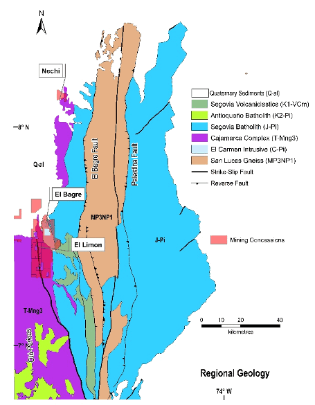
At El Bagre, the veins of La Ye, Mangos, and Cordero are hosted in shear zones with fragile ductile deformation within carboniferous granite rocks of the El Carmen stock. At the regional level, the main structure to the west is the sinistral Otú fault system which trends north-south to north-northwest near the municipality of Zaragoza. El Limon and the bulk of Soma’s Zara concessions are on the Otú fault. This fault which brings into contact carboniferous plutonic rocks from the El Carmen stock with metamorphic Permo-Triassic rocks grouped regionally as the Cajamarca Complex.
The Otú fault is the most northern expression of the Otú-Pericos fault system. To the east is the El Bagre fault, interpreted regionally as an overrun fault, which brings the Segovia batholith into contact with Precambrian metamorphic rocks grouped in the San Lucas Gneiss. To the southeast are volcano-sedimentary deposits of Segovia and to the north are the sedimentary rocks of the Caucasia Formation, the Tarazá Formation, and the recent deposits of the Nechí and Tiguí rivers, which mask the trace of the Otú fault and cover discordantly the granite rocks of the Segovia batholith and El Carmen stock.