GOWGANDA WEST PROPERTY
When looking for gold, the excitement generated is the path undertaken when trying to recognize hidden value. One of the most basic concepts implemented when searching for gold, is to look for gold where it has been found before.
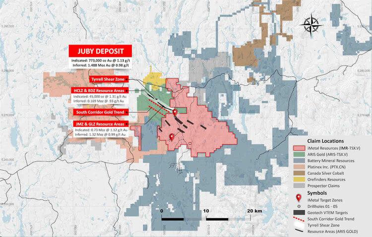
iMetal Resources was drawn to the Gowganda West property because it covers the projected eastward extension of the structural trend that hosts the Juby deposit. This deposit is currently owned by Aris Gold Corp. (TSX:ARIS) and hosts 1.1 million ounces of gold in the Measured & Indicated category and 2.9 million oz of gold in the Inferred category.
iMetal Resource’s Management team recognized that the Gowganda West property warranted additional field exploration activity. The project had in the past been ignored for various reasons but mainly because the property appeared to be underlain by barren meta-sedimentary rocks and a thin layer of overburden. Based on these assumptions, more detailed investigations were not performed.
Since acquiring the project, iMetal’s prospectors and geologists have determined that the geology was not mapped correctly and rock types and lithologies are much more favorable and more importantly the same as found in gold deposits in the prolific Kirkland Lake and Timmins Gold camps.
Prospecting and geophysics during the 2018 and 2019 field seasons identified several mineralized zones over a 7 km long strike length that appear to be structurally related. A geophysical survey performed by Geotech in 2019, outlined seven additional shallow (<100 metre deep) targets, four of which have been classified as high priority. These targets are now being evaluated and additional targets are being discovered as prospecting and exploration continue.
View fullsize
LOCATION & ACCESS
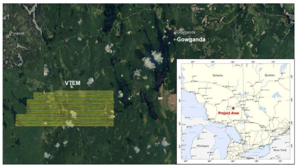
The project is located 17 km WSW of Gowganda Ontario, and 90 km SW of Kirkland Lake Ontario. The property can be accessed year-round by paved highway 560 from Gowganda and via maintained gravel and newly built forest roads and 4WD logging roads that trend south from Hwy 560.
View fullsize
REGIONAL GEOLOGY
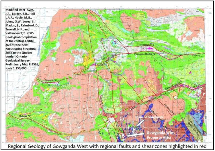
Geological Compilation of the Central Abitibi Greenstone belt: Kapuskasing Structural zone to the Quebec Boarder. Highlights regional geology of Gowganda West Property including significant gold controlling fault and shear zones highlighted in red.
OWNERSHIP
iMetal has a 100% interest in the Gowganda West property. Of the nearly 150 square-km, 20 square-km are subject to a 3% Net Smelter Return Royalty. One half of the NSR can be purchased for $1 million. The northern portion of the property is covered by the Mosher Lake Option Agreement, the terms of which have been met subject to a 3% NSR.
2019/20 DRILL PROGRAMS SUMMARY
Assay results from drill hole programs indicate that the gold mineralization encountered to date appears to be part of, proximal to and within an extensive large near surface hydrothermal alteration and gold mineralizing system.
iMetal Resources believes that this gold bearing hydrothermal system was allowed to percolate through a large volume of favourable host rock and develop a strong alteration assemblage (as witnessed in drill core analysis) and also to have widespread deposition of disseminated pyrite and with associated gold mineralization established.
DOWNLOAD REPORTS
**GOWGANDA WEST PROJECT - GEOLOGICAL SETTING & DISCUSSION (PDF)**
**Gowganda West 2019 DDH Assess Rpt 2020 (PDF)**
LOCAL GEOLOGY
The Zone 1-South Area surface gold showings and the Zone 3 surface gold showings occur within the mixed meta-sedimentary lithologies consisting of, conglomerate, arenite greywacke, and minor mudstone of the Indian Lake Group (I.L.G.). Recent geochronological age dating by Ayers et al 2013 indicates that the I.G.L. is 2690-2680 Ma and Archean aged and is therefore part of the Porcupine assemblage. This new interpretation is based on age determinations from felsic volcanic rocks and intercalated clastic meta-sedimentary rocks very close by and near the property boundary to the north. Intermediate to felsic intrusive rocks were also dated as 2687-2686 Ma and are synvolcanic with the I.L.G. of Porcupine volcanic and meta sedimentary assemblage.
The I.L.G. meta-sedimentary lithologies exhibit spectacular bright red to maroon red jasper grit, granules, pebbles to boulders that are also very commonly found in the slightly younger Timiskaming assemblage (2676-2670 Ma) that also commonly occur within the regional significant gold camps both, at and near Kirkland Lake and Timmins, Ontario.
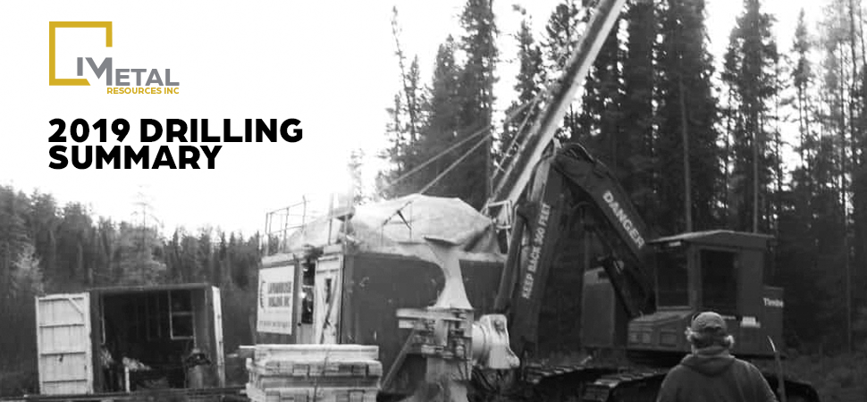
The Zone 1-South Area was drill tested with 5 diamond drill holes totaling 1258 meters and were completed with approximately 251 meters per hole in February 2019. All drill holes intersected the Archean aged I.L.G. clastic meta-sedimentary lithologies including mudstone, arenite and conglomerate that have been intruded by intermediate composition hornblende porphyry aplite dikes and by felsic composition feldspar quartz porphyry dikes. Early Proterozoic narrow diabase dikes with finely disseminated magnetite and exhibiting a moderate to strong magnetic signature cut the meta- sedimentary lithological sequence locally.
Assay results for the 5-diamond drill hole program seems to indicate that the gold mineralization encountered to date appears to be part of, proximal to and within an extensive large near surface hydrothermal alteration mineralizing system. The nature of the Indian Lake Group meta-sedimentary lithological sequence near Zone 1 & Zone 3 exhibits a strong to extensive presence of a coarse clastic sedimentary polymictic conglomerate unit. This pebble to boulder conglomerate that also includes red jasper clasts appears to have acted as a superb permeable and porous favorable host rock for hydrothermal fluid migration, alteration and eventual deposition of disseminated pyrite and gold.
The ddh’s that carry variable gold mineralization tends to be associated with fine grained disseminated trace 5% pyrite and occasionally with trace chalcopyrite locally. This mineralization occurs within all of the meta-sedimentary lithologies and is especially associated within all of the meta-sedimentary lithologies that exhibit strong pervasive hydrothermal alteration. This alteration consists of pervasive bleaching and silicification, flecks wisps and filament lamellae of sericite and fuchsite sericite imparting a ‘green carbonate’ alteration locally, ankerite veinlets, chlorite healed micro-fractures and stringers, quartz stringers and veinlets, quartz ankerite stringers and veinlets, and locally pervasive interstitial calcite and calcite stringers. Peripheral to moderate to strong hydrothermal alteration zones are the more flanking and more distal weaker alteration zones that consist predominantly of calcite stringers and veinlets as well as locally pervasive to patchy interstitial calcite, and locally weak epidote.
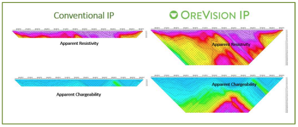
Thus, the objective of this survey is to detect sulphide-rich (mainly chalcopyrite and pyrite) mineralized zones that may contain gold mineralization associated with a hydrothermal alteration system. Sulphide minerals such as pyrite and chalcopyrite produce strong and easily detectable Induced Polarization (IP) anomalies, particularly in a disseminated style. A deeply exploring Induced polarization method such as OreVision® is therefore an appropriate tool for this exploration program.
GEOPHYSICS
DETAILED GROUND GEOPHYSICS
In October, 2019, a 46.5 line-km induced polarization (“IP”) survey was completed on the Gowganda West project by Abitibi Geophysics Inc using their proprietary OreVision® IP technology. The survey targeted iMetal’s Zone 1 South and Zone 3A/3B.
**DOWNLOAD THE FULL REPORT (PDF)**
AIRBORNE GEOPHYSICS
In 2019 a Geotech VTEM airborne survey was flown over the northern portion of the property early this year. Geotech outlined seven shallow (<100 metre deep) targets, four of which were given high-priority status.
The survey area was flown by Helicopter in an east to west direction with traverse line spacings of 100 metres. Principle geophysical sensors included a Versatile Time Domane Electromagnetic (VTEM Plus) system and a horizontal magnetic gradiometer with two caesium sensors. A total of 589 line-kilometres of geophysical data were acquired during the survey.
Geotech identified Seven targets of possible polymetallic vein gold mineralization in the Gowganda West Survey area. Results of the geophysical survey are shown in maps below.
**DOWNLOAD THE FULL REPORT (PDF)**
View fullsize
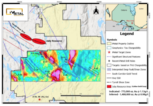
Target areas with respect to shallow (<100 metre deep) Tau Chargeability Anomalies and interpreted deep structures (which may represent feeder structures for mineralization).
View fullsize
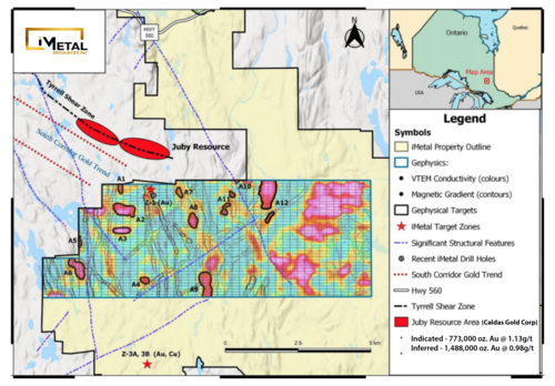
A number of potential gold targets based on favourable VTEM conductivity high and magnetic low associations.
View fullsize
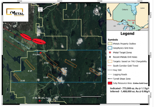
Map showing Gowganda West property with Geotech Targets.
View fullsize
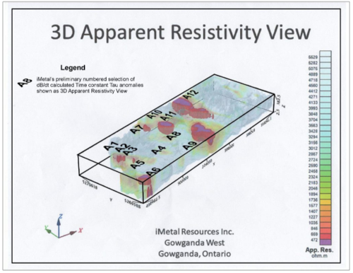
3D view of Apparent Resistivity. Hot Colours represent Low Resistivity and highlight 12 additional geophysical targets.
About Gowganda West
The Gowganda West property covers approximately 147 sq km in the Shining Tree volcano-sedimentary succession of the southwestern Abitibi Greenstone Belt contiguous to the north and west of Aris Gold Corp.'s (formerly Caldas Gold Corp.) Juby Gold deposit, a series of four mineralized alteration zones along the Tyrrell Shear Zone. Gold mineralization at Juby is associated with narrow quartz-carbonate-pyrite veins hosted within 20 to 330 metre wide zones of ankerite-albite-silica-sericite alteration and variable amounts of fine-grained, disseminated pyrite and also with multiple lenses containing narrow (<5m), higher grade quartz-carbonate-pyrite veins hosted within 5 to 50 metre zones of ankerite-albite-silica-sericite alteration and variable amounts of fine-grained, disseminated pyrite. The Juby Deposits host indicated resources of 774,000 ounces at 1.13 g/t Au and inferred resources of 1,488,000 ounces at 0.98 g/t Au. iMetal cautions investors mineralization at Juby is not necessarily indicative of similar mineralization at Gowganda West.
Source: Technical Report on the Updated Mineral Resource Estimate for the Juby Gold Deposit for Caldas Gold Corp. (named currently changed to Aris Gold Corp.) Dated 2020-Oct-05 By: J. Campbell, A. Sexton, D. Studd, and A. Armitage.
iMetal acquired Gowganda West in 2016, discovering Zone 1 and Zone 3 through focused exploration proximal to the Aris property border, and subsequently completing programs of prospecting, channel sampling, airborne VTEM, ground IP and limited diamond drilling.
Zone 1 has excellent access and has been traced over 500m south from the Juby property boundary. Two distinct outcrop areas approximately 300m apart have been sampled, Zone 1 and Zone 1 South. Highlight grab samples include: 6.47 g/t Au from Zone 1 and 39.3 g/t Au, and 16.9 g/t Au from Zone 1 South. Six holes were subsequently drilled at Zone 1, focusing on a short 150 strike length of Zone 1S. Highlight drill intersections included: 2.95 g/t Au over 2.5 metres, 1.43 g/t Au over 4.6 metres and longer intervals of 0.37 g/t au over 29.4 metres and 0.32 g/t au over 30.25 metres. Zone 3 consists of two distinct areas, 3A and 3B approximately 6 kilometres due south of Zone 1, separated by 225 metres. Highlight Zone 3A grab sample results include 56.59 g/t Au and 34.81 g/t Au, while highlight Zone 3B grab sample results include 14.74 g/t Au and 12.7 g/t Au. Zone 3A and Zone 3B remain undrilled