GLACIER -gate
SEE TWO
NO MERRI
now refers to glaciers as well bak 819
see IPCC 4th
see sep on scandal(s) itself
dr dis prep BS
primary on conveyor belt thermocline EU
see ANWR, carbon bomb, drinking water
see sea level rise
also drought?
---
an 224 spate
Antarctic tipping point that occurred 8,000 years ago 'could happen again' - Alternet.org
thom 3 wisc winter hurric
Category 6? Scientists highlight 'growing inadequacy' of current hurricane scale - Alternet.org
---
https://www.alternet.org/2022/06/scientists-spooked-south-pole-stability/
==
predictable mo-fo
https://climate.nasa.gov/news/3008/stunning-forecast-a-century-of-ice-loss-for-nearly-100000-glaciers/
Pat Brennan,
NASA's Jet Propulsion Laboratory
The ice in one of the world’s highest concentrations of non-polar glaciers could see significant melting before the end of the century, potentially affecting sea levels around the globe, according to a new computer model from the NASA Sea Level Science Team.
The region, known as High Mountain Asia, could see ice loss run from 29 to 67 percent, depending on the level of greenhouse gas emissions over the period modeled.
According to the study, water flow in monsoon-fed river basins, driven largely by melting glaciers, could hit its peak by 2050 – potentially reducing runoff beyond that time and forcing changes in how water is consumed, or forcing communities to find other water sources. Understanding the coming changes in such flows is critical to proper planning for hydropower, irrigation, and water supplies.
A Leap Forward in Glacier Modeling
The new “Python Glacier Evolution Model,” or PyGEM, uses extensive data sets, instead of less detailed estimates from isolated, regional effects or extrapolations based on a small number of glaciers.
“This is a huge advance compared to previous studies,” said David Rounce, a researcher at the University of Alaska, Fairbanks, and a member of the NASA Sea Level Science Team, who is lead author of the new modeling study. “We are able to assess changes in glacier mass and runoff at an unprecedented scale.”
By sheer number, High Mountain Asia accounts for 44 percent of all the glaciers in the world—apart from the Greenland and Antarctic ice sheets—though it accounts for only a fraction of glacial mass. The melting of these glaciers over decades contributes significantly to rapid, and accelerating, global sea-level rise.
As they grow in power and precision, computer models are revealing the intricate dance of climate, ice-melt, and sea-level rise with increasing clarity.
The High Mountain Asia region, which could see substantial loss of glacial ice in the decades ahead, a new study shows. Image courtesy of David Rounce.
The key to the sweeping new modeling method is its grounding in hard data. The science team studied changes to 95,536 glaciers from 2000-2018, as observed by the Advanced Spaceborne Thermal Emission and Reflection Radiometer (ASTER) aboard NASA's Terra satellite (Shean et al., 2020). The observations cover nearly every glacier in High Mountain Asia, which covers an area of 38,000 square miles (98,000 square kilometers), including those too small to be captured in previous studies.
**Get a Monthly Digest of NASA's Climate Change News:** Subscribe to the Newsletter »
This allowed the team to estimate the decline in ice mass – the quantity of ice in terms of “weight,” or heft – for each glacier; reassembling these estimates into a regional mosaic yielded broad coverage of a vast glacial area as well as forecasts for smaller zones within it.
“The models are certainly becoming a lot more powerful,” Rounce said. “Observations are starting to become available for almost every glacier, which is truly unprecedented when we consider that a decade ago, global glacier evolution models were relying on data from less than 300 glaciers.”
Questions on Future Emissions
Despite the model’s wide scope and high precision, its forecasting power is subject to the same limitation as previous projections: researchers don’t know whether emissions of heat-trapping greenhouse gases will increase, decrease, or stay the same in the decades to come. To account for this, the team used the standard practice of delivering a range of forecasts under scenarios, for higher, lower, and largely unchanged emissions.
On the plus side, Rounce says, PyGEM is among the first models of its kind to be made available to the scientific community as an “open source” code – allowing any researcher to plug in data and run the model.
To that end, Rounce spent weeks in Innsbruck, Austria, working with another researcher to make PyGEM compatible with the Open Global Glacier Model, another open-source model published last year.
The new work also could help planners prepare for future sea-level rise.
"Thyis is a super-exciting area of work because it will truly enable us to push the science forward as a community, as opposed to pushing things forward as a bunch of individual research groups," he said.
Read the study, **"**Glacier Mass Change in High Mountain Asia Through 2100 Using the Open-Source Python Glacier Evolution Model (PyGEM)"
This article was originally published on NASA's Sea Level Change Portal.
==
Greenland’s Nearing a Climate Tipping Point. How Long Warming Lasts Will Decide Its Fate.
:{BY: BOB BERWYN
Past meltdowns occurred with temperatures only slightly higher than today's, suggesting the world is overestimating the ice sheet's stability, a new study found. Read More}:
==
icn 1019
I
in the Mountains, Climate Change Is Disrupting Everything BY: BOB BERWYN The melting of mountain glaciers and loss of snow is already having a cascading effect on ecosystems, agriculture and billions of people downstream. |
| Read More |
==
https://www.c-span.org/video/?461595-1/the-ice-end-world
JUNE 11, 2019
The Ice at the End of the World
Science journalist Jon Gertnertalked about his book, The Ice at the End of the World: An Epic Journey Into Greenland’s Buried Past and Our Perilous Future, in which he explored the history of ice on Greenland and argued that the layers provide insight to future climate conditions. close
==
https://www.ecowatch.com/icelandic-glacier-monument-2639301498.html
plaque
==
619
Arctic death spiral speeds up sixfold, driving coastal permafrost collapse
:{
}:
:{
Drone surveys have revealed erosion of coastal permafrost in the Arctic — up to 3 feet a day. Researchers reported Friday that the recent rate of erosion is six times higher than the historical rate.
Meanwhile, the Arctic just saw the hottest May on record, with temperatures in northwest Russia hitting a remarkable 84 degrees Fahrenheit (29 degrees Celsius). Global warming is driving Arctic sea ice to near-record lows, which in turn is driving ever-worsening summer heat waves in the southern United States, according to another new study.
In the first study, a team led by University of Edinburgh scientists flew drone-mounted cameras over a section of permafrost coastline in the Canadian Arctic.
They found that during a 40-day period in the summer of 2017, the coast had retreated a remarkable 47 feet — with daily rates of collapse sometimes exceeding 3 feet,
"Big chunks of soil and ground break off the coastline every day, then fall into the waves and get eaten away,” co-author Dr. Isla Myers-Smith, a University of Edinburgh geoscientist, explained.
This rate of erosion was more than six times greater than the historical average experienced in the previous half century.
The most dangerous climate feedback loop is speeding up
In Siberia, the carbon-rich permafrost warmed by 1.6°F in just the last decade.
The permafrost, or tundra, is soil that stays below freezing (32 degrees Fahrenheit) for at least two years. Thawing permafrost is a dangerous amplifying feedback loop for global warming because the global permafrost contains twice as much carbon as the atmospheredoes today .
As the permafrost melts, it releases heat-trapping carbon dioxide and methane, and as the coastline disintegrates and erodes, more and more permafrost will be exposed to the warming air and water.
This means, as the planet continues to warm, more permafrost will erode and melt, releasing even more greenhouse gases in a continuous feedback loop.
A 2017 study found the Alaskan tundra is warming so quickly it had become a net emitter of CO2 ahead of schedule. That study was the first to report a major portion of the Arctic had already become a net source of heat-trapping emissions.
As the Arctic warms, the ice retreats — and the recent record Arctic temperatures have led to the second lowest amount of sea ice on record for June (after 2016).
[scary diagonal down graf]
ARCTIC SEA ICE EXTENT (IN MILLIONS OF SQUARE KILOMETERS). CREDIT: ZACH LABE.
Such ice loss is a key reason climate models have long predicted that human-caused warming would be at least twice as fast in the Arctic as elsewhere. When highly reflective sea ice melts due to higher temperatures, it is replaced by the dark blue sea which absorbs more solar energy, leading to more melting.
A study released last week in the Journal of Geophysical Research found that loss of Arctic sea ice is making extreme heat waves more likely. The study concludes that “low summer sea ice in Hudson Bay is statistically linked to an increased frequency of summer U.S. heat waves,” especially in the U.S. Southeast and southern Plains.
The study also finds that the melting sea ice is weakening the jet stream. A weaker jet stream causes summer weather systems to stall, leading to longer and stronger heat waves — and other extreme events, as recent studies have reported.
Back in December, the annual Arctic Report Card from the National Oceanic and Atmospheric Administration (NOAA) noted that “Growing atmospheric warmth in the Arctic results in a sluggish and unusually wavy jet-stream that coincided with abnormal weather events in both the Arctic and mid-latitudes.”
What happens in the Arctic does not stay in the Arctic. Unless we start cutting carbon pollution sharply and rapidly, we can expect Arctic temperatures to soar in the coming decades, bringing ever worsening extreme weather to this country.
}:
mashey 2012
(heartland?)
p138
Z.2005.01-16 Letter to Senator McCain
Scientists Dispute Sensational Claims of Arctic Ice Melt
“Eleven distinguished 690 scientists, most of whom specialize in climatology 691
,...ball, lupo, legates, michaels, roy spencer, willie soon, baliunas sallie...
on November 16 published an open letter to Senator John McCain (R-AZ), who
has repeatedly sponsored congressional legislation that mirrors the Kyoto
Protocol, which was rejected by the U.S. Senate in 1997 by a vote of 95-0. The
letter disputes assertions by McCain and other alarmists that the Arctic climate is
undergoing remarkable and catastrophic climate change. At the right are excerpts
from the text of the letter.
Z.2005.01-17 Willie Soon and Sallie Baliunas
Consensus Can Be Bad for Climate Science
Z.2005.01-17a S. Fred Singer
Arctic Ice Hype
==
Antarctica’s fourth largest ice shelf susceptible to hydrofracture and collapse from winter winds
Recent findings on Antartic ice shelves show that they are…
==
omg
Pompeo actually just cheered the ‘new opportunities’ presented by the Arctic’s melting ice sheets
by Cody Fenwick May 6, 2019
Secretary of State Mike Pompeo has never been terribly worried about climate change, but in a new speech to the Arctic Council Ministerial Meeting in Finland on Monday, he seemed…
==
https://grist.org/article/the-arctics-ticking-carbon-bomb-could-blow-up-the-paris-agreement/
yoder 3/19
Even in a dream-come-true scenario where we manage to stop all the world’s carbon emissions overnight, the Arctic would inevitably get hotter and hotter. That’s according to a new report by U.N. Environment, which says the the region is already “locked in” to wintertime warming of 4 to 5 degrees C (7.2 to 9 degrees F) over temperatures of the late 1900s.
The report, released at the U.N. Environment conference in Kenya on Wednesday, says that theArctic is warming twice as fast as the planetary average, and models show that it’s on track to become ice-free during the summer as soon as 2030.
That’s the bad news. So here’s even worse news. The Arctic contains much of the world’s permafrost, which holds what the report calls a “sleeping giant” made of greenhouse gases. As the ground warms, the microbes in the soil wake up and start belching greenhouse gases. Estimates vary, but the report says1.5 trillion tons of carbon dioxide lurk beneath the Earth’s permafrost. That’s more than 40 times as much CO2 as humans released into the atmosphere last year, and double the amount of the gas in the atmosphere today.
If that permafrost stayed permanently frozen, as the word itself suggests it should, we could continue worrying about other stuff. But researchers expect Arctic permafrost to shrink 45 percent compared to today. Unleashing that stored-up carbon dioxide and methane would obviously “derail efforts” to limit warming to 2 degrees C (3.6CK degrees F) as outlined in the Paris Agreement, the report says. But then again, it would derail pretty much everything.
“New evidence suggests that permafrost is thawing much faster than previously thought, withconsequences not just for Arctic peoples and ecosystems, but for the planet as a whole because of feedback loops,” the report states.
This is one of the runaway warming scenarios, often called the “carbon bomb” or “methane bomb.” (Permafrost holds both greenhouse gases.) Unlike a real bomb, however, it wouldn’t explode all at once. And at least one recent study suggests that we still have time to defuse it.
Within the Arctic, the soil formerly known as permafrost — let’s call it “meltafrost” — could pose a danger to 70 percent of current infrastructure by 2050, as well as the region’s 4 million inhabitants, 10 percent of whom areindigenous. Recent studies have shown that permafrost thaw could cause houses to collapse, lead to uneven roads, and threaten important cultural and archaeological sites.
The North Pole runs warmer than the rest of the planet because of a phenomenon called “Arctic amplification” — basically a region-specific term for feedback loops. “[W]hen sea ice melts in the summer, it opens up dark areas of water that absorb more heat from the sun, which in turn melts more ice,” the report explains.
These rapid changes in the Arctic might seem far away, but you will feel them, too. For those of you on the coasts, keep in mind that the melting of Arctic glaciers and Greenland’s ice sheet makes up a third of sea-level rise around the globe. Rising seas will wreak havoc in coastal regions as they deal with flooding, damaged buildings, and the saltwater contamination of drinking water sources.
And for those further inland, there’s the wild weather. The melting of the Arctic causes changes in the jet stream and disrupts weather patterns much further south. It’s been linked to worsening drought across the western United States, stalled hurricanes in the East, and the polar vortex that occasionally dips down over North America to turn us all into popsicles.
As many are fond of saying, “What happens in the Arctic does not stay in the Arctic.”
==
india and paki fight for water in Kashmir? Dar Jamal ice bk
Are **India** **and** Pakistan on the Verge of a **Water** War?
https://foreignpolicy.com/2019/02/25/are-india-and-pakistan-on-the-verge-of-a-water-war-pulwama-kasmir-ravi-indus/
Interview Are India and Pakistan on the Verge of a Water War? In reprisal for a deadly terrorist attack in Kashmir, the Indian government says it will divert river waters that downstream Pakistan ...
**India** to cut **water** to Pakistan as **Kashmir** conflict escalates ...
https://www.dw.com/en/india-to-cut-water-to-pakistan-as-kashmir-conflict-escalates/a-47622188
News India to cut water to Pakistan as Kashmir conflict escalates. The move has come amid rising tensions in Kashmir after an attack on an Indian military post.
==
https://www.alternet.org/2019/02/theres-a-giant-hole-in-the-worlds-most-important-glacier/
==
Dahr Jamail
The End of Ice bookAudio interview 1/19 non-linear cascade effect. see more climate books).
https://YYY.theguardian.com/news/audio/2019/jan/28/when-the-ice-melts-the-catastrophe-of-vanishing-glaciers-podcast
...
Our planet is rapidly changing, and what we are witnessing is unlike anything that has occurred in human, or even geological, history. The heat-trapping nature of CO2 and methane, both greenhouse gases, has been scientific fact for decades, and according to Nasa, “no question that increased levels of greenhouse gases must cause the Earth to warm in response”. Evidence shows that greenhouse gas emissions are causing the Earth to warm 10 times faster than it should, and the ramifications of this are being felt, quite literally, throughout the entire biosphere.
Oceans are warming at unprecedented rates, droughts and wildfires of increasing severity and frequency are altering forests around the globe, and the Earth’s cryosphere – the parts of the Earth so cold that water is frozen into ice or snow – is melting at an ever-accelerating rate. The subsea permafrost in the Arctic is thawing, and we could experience a methane “burp” of previously trapped gas at any moment, causing the equivalent of several times the total amount of CO2 humans have emitted to be released into the atmosphere. The results would be catastrophic.
Climate disruption also brings with it extreme weather such as hurricanes and floods. For instance, a warmer atmosphere holds more moisture, leading to an increase in the frequency of severe major rain events, such as Hurricane Harvey over Houston in summer 2017, which dropped so much rain that the weight of the water actually caused the Earth’s crust to sink by 2cm.
Earth has not seen current atmospheric CO2 levels since the Pliocene epoch, some 3m years ago. Three-quarters of that CO2 will still be here in 500 years. It takes a decade to experience the full warming effects of CO2 emissions. Even if we stopped all greenhouse gas emissions, it would take another 25,000 years for most of what is currently in the atmosphere to be absorbed into the oceans.
A skier overlooks a glacial pool in the upper Ruth Glacier in Denali National Park and Preserve.]
Climate disruption is progressing faster than ever, and faster than predicted. Seventeen of the 18 hottest years ever recorded have occurred since 2001. The distress signals from our overheated planet are all around us, with reports, studies and warnings increasing daily. Worst-case prediction made by the Intergovernmental Panel on Climate Change about the rise in temperatures, extreme weather, sea levels and CO2 levels in the atmosphere have fallen short of reality. Countless glaciers, rivers, lakes, forests and species are already vanishing at a pace never seen before, and all of this from increasing the global mean temperature by “only” 1C above the preindustrial baseline. Some scientists predict it could rise by as much as 10C by 2100. A study led by James Hansen, the former director of Nasa’s Goddard Institute for Space Studies, warned that the rise we have seen so far has already caused unstoppable melting in both the Antarctic and Greenland ice sheets.
Mountaineering in today’s climate-disrupted world is a vastly different endeavour from what it used to be. Glaciers are vanishing before our eyes, having shrunk to the lowest levels ever recorded, and are now melting faster than ever. Seventy per cent of the glaciers in western Canada are projected to be gone by 2100. Montana’s Glacier National Park will most likely not have any active glaciers by 2030. The Matanuska Glacier’s ancient ice is already rapidly vanishing. Dramatic changes are occurring even in the planet’s highest and coldest places. Even Mount Everest is transforming, as thousands of glaciers across the Himalayas are likely to shrink by up to 99% by 2100. A child born today will see an Everest largely free of glaciers within their lifetime.
...
Permafrost Is Warming Around the Globe, Study Shows
:{BY: BOB BERWYN
Rapid changes in the long-frozen soil are raising concerns about a surge of planet-warming greenhouse gases as the permafrost thaws.}: Read More
==
ngo 6/18
most recent study on the ice of the world’s highest mountain range gives Toha reason to build his ark. Experts on climate and hydrology concluded in 2015 that the Himalayan glaciers have increasingly retreated to the summits. The protagonist of the film symbolizes those who are already suffering directly from the melting of the ice water body. These are communities that have lived by the glaciers since their ancestors settled there centuries ago, and have now run out of their main source of water in the hottest summer months: the ice.
The study was carried out by the Nepali International Centre for Integrated Mountain Development The increase in rainfall and snowfall in the mountain range, predicted by the Intergovernmental Panel on Climate Change (IPCC), will not compensate for the thawing caused by the rise in atmospheric temperature. The iconic photograph of the immense white mountain ranges crowned by Everest may radically change to the grey of bare rocks in less than a century.
The human problem spreads downstream, as the Indus River in Pakistan, the Ganges and Yamuna Rivers in India and the Bramaputra River in India and Bangladesh, whose waterways are among the most polluted in the world, suffer the consequences of melting ice as the seasonality of floods and the water quality change. On the other hand, satellite data (see article) showed in 2009 that the aquifers of the upper Ganges basin were falling at a rate of 33 cm in their water table each year. In addition to the overexploitation of groundwater, vital for agriculture, the cause of this loss is the decline in glacial ice.
The bad news about the ice on the world’s roof also comes from the northern slope of the mountain range. Another study, driven by the Chinese government, concludes that 247 km2 of the more than 46,000 glaciers in Tibet, almost 15% of the world’s remaining glaciers, melt each year. These glaciers are the source of the largest rivers in China: the Yangtze, the Hongshui and the Yellow River. FAO warns that if the rivers on the Eastern slope are added to this list, such as the Irawadi, which runs through Burma, and the Mekong, which irrigates China, Laos, Cambodia and Vietnam, and which are also affected by the alteration of the ice upstream, the subsistence of more than 2 billion people, almost 30% of the world’s population, is threatened.
The health of the Earth’s glaciers is not a distant issue: it is vital for the health and balance of the planet. Mitigating global warming is an obligation for all the governments around the world, which cannot fall into the irresponsible selfishness of short-term political and economic strategies; but it is also an obligation for each one of us: thinking about the ice that melts every time we open we tap or hit the light switch can change the fate of the Earth.
==
nature 2010
Global warming's impact on Asia's rivers overblown
Freshwater flow dominated by monsoon rains rather than glacier run-off.
Richard A. Lovett
Although global warming is expected to shrink glaciers in the Himalayas and other high mountains in Central Asia, the declining ice will have less overall impact on the region's water supplies than previously believed, a study concludes.
It's an important finding, says Richard Armstrong, a climatologist at the US National Snow and Ice Data Center in Boulder, Colorado, who notes that the Intergovernmental Panel on Climate Change had previously predicted dire restrictions on water supplies in Asia. "There clearly were some misunderstandings," he says.
The researchers behind the latest study began by calculating the importance of meltwater in the overall hydrology of five rivers: the Indus, the Ganges and the Brahmaputra in India, Pakistan and Bangladesh, and the Yellow River and the Yangtze in China1. The authors found that meltwater is most important to the Indus, with a contribution roughly 1.5 times that from lowland rains. In the Brahmaputra, meltwater flow is equivalent to only one-quarter of the volume supplied by lowland rainfall, and, in the other rivers, it forms no more than one-tenth of the input.
Furthermore, the study found that in the Indus and Ganges basins, glacial ice contributes only about 40% of the total meltwater, with the rest coming from seasonal snows. In the other three rivers its contribution is even lower.
High and dry?
That's important, says Walter Immerzeel, a hydrologist at FutureWater in Wageningen, The Netherlands, and lead author of the study1, because Asian rivers are fed by three sources: rain, snow melt and melting glaciers.
The first two are driven by current weather patterns, because rains fall either as water or as snow that will later melt. The last is a carry-over from the build-up of glaciers in prior centuries. As the glaciers shrink, their contribution will also decline until the glaciers have either melted entirely, or stabilized at smaller sizes.
“The glaciers are tiny, compared with the monsoon.”
Climate change will therefore have two effects, Immerzeel says. One will be to reduce the contribution of glaciers to total run-off. The other will be to change weather patterns, including rain and snowfall. Combining these and looking at averages from five climate models, Immerzeel and colleagues concluded that the change in upstream water inputs will range from a decrease of 19.6% for the Brahmaputra to a 9.5% increase for the Yellow River. The latter, he notes, is due to increased winter rains. "The Yellow River depends only marginally on meltwater," he says, "and, on average, the models project an increase in winter precipitation in the Yellow River basin."
What this means, Armstrong says, is that river flows are dominated by seasonal rains. "The glaciers are tiny, compared with the monsoon," he says.
Nevertheless, the study concludes that climate change will reduce water supplies enough that by 2050, declines in irrigation water are likely to reduce the number of people the region's agriculture can support by about 60 million — 4.5% of the region's present population.
...
https://www.chinadialogue.net/article/show/single/en/9654-Source-of-Mekong-Yellow-and-Yangtze-rivers-drying-up
2017
...LQ): After years of research you’ve found that the headwaters of the Lancang are seeing seasonal dry-outs. Can you describe these changes?
:{
Yang Yong (YY): We’ve made several trips to the headwaters of the Lancang. MEKONG] Before 2006 this was a very difficult trip, and you had to walk the last 20 kilometres or so.
During our 2016 trip we found the headwaters were experiencing seasonal dry-outs, for example, along tributaries such as the Angua and the Gelong we saw large expanses of exposed sand shoals.
We usually drive along the rivers towards the headwaters. In the summer of 2006 there was too much water and we got stuck in the river. We tried to find a way through the marshes, but the marshes were too wet. We never made it to the source of the river. When we visited in the summer of 2014 we found some of the rivers were lower and we were able to reach the sources of two rivers.
Because of the degradation of the river systems and reduced flows in recent years, more and more survey teams have been able to reach the headwaters, including some adventure tourists and science teams.}:
:{
Dry-outs are making previously inaccessible areas of Sanjiangyuan more open to tourists. (Photo by Yang Yong)
}:
:{LQ: What impact will those dry-outs have?
YY: Seasonal dry-outs don’t just affect the evenness of river flow, the amount of water flowing from the Lancang reserve, and the ecosystem’s ability to store water. They also lead to the drying out of marshes and wetlands and the degradation of pastures. There are many herders in the Sanjiangyuan reserve and it is }::{:{already common to see degraded pastures and localised desertification.}:
During our 2016 trip we looked at problems with pastures and found that grazing has stopped in some locations, with }:herders forced to expand their range. Desertification is a warning for the Lancang reserve. Livestock herders in these areas need to respond to the changes to avoid over-grazing. Pastures should be rotated to ensure they have time to recover.
Grassland degeneration in Sanjiangyuan. (Photo by Yang Yong)
:{LQ: What is causing these seasonal dry-outs?
YY: It’s mainly due to climate change. Glaciers at the headwaters are receding quickly. Peaks of 5,800 metres are now covered only with a thin layer of ice, in some cases even in gullies there’s only a little ice on the shaded side of the mountains. This means less melt water flowing into the rivers. Some of the headwaters, which rely on groundwater and precipitation, dry out due to a lack of water supply.
LQ: What other challenges is the Lancang region facing?
YY: Recent hydropower and mining development have increased pressure on the environment in the Lancang basin.
We’ve been tracking hydropower development on the Lancang for several years and found that building on the lower and middle reaches is either complete or already underway, which means that development is moving further upstream. Some hydropower plants are in geologically active areas, or areas where the local ecology is extremely vulnerable. Add to this other intensive human activity such as agriculture and mining, and the environment is struggling to cope.
On the middle reaches of the river, mining and hydropower are being developed simultaneously, compounding the damage. On some stretches of the river we saw tailings ponds, waste piles, and the pollution left behind after mining.}:
:{
A mid-range hydropower construction on the Lancang. (Photo by Yang Yong)
}:
:{LQ: What impact will the creation of the reserve have on the ecology of the river basin?
YY: The idea of the reserve is to restrict industrial development such as hydropower and mining. It also indicates that the region will focus on building tourism and environmentally-friendly sectors, rather than relying on resource extraction and GDP figures.
The creation of the reserve will create more jobs in environmental protection, and encourage the local herders to work in businesses providing tourism or educational services in exchange for a stable income.
The development of Yushu prefecture will be closely linked with the reserve, and we hope to see a new balance there between conservation and development.
LQ: You’ve been exploring the reserve and its scenery, can you talk about what you found?
YY: Ninety percent of the reserve lies in Yushu prefecture. In 2014 we were invited by the Yushu government to carry out a detailed survey of the Sanjiangyuan region, and in the Lancang reserve area we found a number of unique and world-class scenic spots: hills and forests, cliffs and gorges.
LQ: The Lancang is known as the Mekong once it leaves China. Will other countries downstream benefit from the reserve?
YY: The Mekong rises in China but is one of Southeast Asia’s most important international rivers. It flows 2,130 kilometres through China, where it is known as the Lancang, and then another 2,750 kilometres through Laos, Myanmar, Thailand, Cambodia and Vietnam before reaching the South China Sea.
By creating a nature reserve at the headwaters of that river, China and the local residents are showing they are willing to fulfil their responsibilities and set an example. This will aid the protection and development of the entire river and provide a useful model for downstream countries.}:
==
https://www.21stcentech.com/climate-change-impact-major-rivers-asia/
2013
...The map above shows howAsia’s rivers rely on Himalayan glaciers to provide much of the water that feeds China, India, Vietnam, Laos, Thailand, Burma, Nepal, Bhutan and Pakistan.These glaciers are twenty times the size of those found in the European Alps and feed the Ganges, Indus, Mekong, Yangtze, Huang He (Yellow), Brahmaputra (a major branch of the Ganges), Irrawaddy and Salween rivers which provide drinking water and irrigation for 1.5 billion people in nine countries.
Before we look at the river basins themselves it is important to understand what exactly scientists are observing in the Himalayas and the Tibetan Plateau. The eastern and central parts of this area of the world are seeingaccelerated melting affecting water sourcesfor rivers draining from that area. While the western areas remain unchanged or are seeing glacier growth so that rivers relying on these sources are unaffected.
This variability in the Himalayan glaciers is attributed to the difference in mean altitudes between the western and eastern parts of the mountain and plateau area with the east experiencing greater heating because of terrain features and higher elevation. Other potential factors include atmospheric pollution drifting in from the burning of forests in India and Indonesia, and from desert dust and increased desertification along the edge of the Gobi.
For those areas that continue to rely on the annual monsoon precipitation the melting of alpine glaciers and the snow pack will have less impact. But the monsoons have a lesser affect on the upper reaches of these rivers where headwaters originate. That means if glacial melt increases or decreases it may impact populations in the upper courses more than the monsoon-fed downstream areas. But monsoons are seasonal and from time to time they don’t come and these areas experience drought. It is during these times that the glaciers become the significant provider of continuous river flow. Needless to say if climate change models are right, and most scientists believe very strongly that they are, Himalayan glaciers will play a significant and growing part in the increasing water crisis in this part of the world.
So let’s look at these glacier fed rivers and the enormous importance each plays for the people, animals and plants that live along their banks.
Ganges River
Also known at the Ganga stretches 2,525 kilometers (over 1,500 miles). The main river originates from the melt-water of the Gangotri Glacier in the western Himalayas and flows south and east through an enormous flood plain to its delta on the Bay of Bengal. In Bangladesh the river is joined by its main tributary, the Brahmaputra. The Ganges crosses much of Northern India and Bangladesh. A number of its lesser branches originate in land-bound Nepal.
The Ganges River Basin serves as the agricultural heartland of both India and Bangladesh and the most heavily populated river basin in the world. The river has been dammed for generating hydroelectricity. Much of it is subject to seasonal monsoons with river levels fluctuating dramatically. Water is drawn off for irrigation as well. It is a water source for cities that lie along its course. Industries draw from it. And it is sacred to Hindus.
Today the river faces serious challenges from water overuse with some areas running dry at times. So what will happen should the glaciers of the Western Himalayas experience intensive melting? The Ganges, already running dry in many places would simply cease to exist for periods of time. For the 655 million who depend on it this represents an impending catastrophe.
Indus River
Almost 40% of the water that flows in the Indus River comes from the glaciers of the Tibetan Plateau making it far more vulnerable to any changes in the rate of Himalayan melting. Stretching 2,900 kilometers (1,800 miles) it is Pakistan’s major source of freshwater for urban and agricultural use and a lifeline for the 300 million who live on its banks or near it.
Much of the country through which the Indus flows is extremely arid and other than seasonal monsoons gets little precipitation. This makes it an important source of irrigation and even more susceptible to climate change. The history of the river valley shows just how much small variations in precipitation can exact an enormous toll on people dependent on the river with evidence of an earlier civilization succumbing to past climate events.
Mekong River
Made famous to much of us here in North America because of the Vietnam War, this extraordinary river stretches 4,350 kilometers (2,700 miles) from its origins in the Eastern Himalayas to its delta at the southernmost tip of Vietnam. In China it is known as the Lancang. It contains the second largest freshwater fishery in the world with fish representing the largest protein contributor to the 60 million who live along the river’s banks and tributaries.
The Mekong crosses through four countries (China, Laos, Cambodia and Vietnam) and it is the cooperation of these countries or lack of it that represents a significant threat to the future health of the river basin in the 21st century. China is building numerous dams in the upper Mekong and Laos plans to make similar investments. The dams fulfill the demand for hydroelectricity. The dams already built are impacting river levels downstream significantly. If more (all in the planning stage) get constructed the lower Mekong may run dry. Now add to this climate change with altered seasonal rainfall and rising temperatures in the highland plateaus of the Himalayas affecting glaciation, and the river may encounter even greater fluctuations.
Yangtze River
The third longest river in the world stretching 6,418 kilometers (3,988 miles), the Yangtze is the heart and soul of the Middle Kingdom. It rises from the glaciers of the Tibetan plateau with its basin covering 20% of China. One-third of China population, close to 450 million, live on or near its banks. But increasing melting of the glaciers that feed the Yangtze is threatening the river because unlike the Indus or Ganges, there is no seasonal monsoon to make up the shortfall.
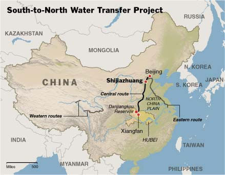
Another Yangtze problem is human water use along the river with much of the flow being taken up by agriculture and industrial use. Today the discharge of raw sewage and industrial pollutants is threatening fish farms and compromising drinking water. Add to this changes in the river flow created by the Three Gorges Dam and the engineering of a South-to-North Water transfer project to replenish the Huang He River to the north and you have a serious water crisis on your hands.
[map china pjt]
Huang He (Yellow) River
China’s second river and the second longest in Asia is as central to the rise of Chinese civilization as the Yangtze is central to the country. Known as the Huang He or Yellow it is 5,464 kilometers (3,395 miles) long and originates to the north of the Yangtze in the Qinghai-Tibetan plateau. It has always been a temperamental river with major floods throughout its history. These have been some of the worst human disasters ever recorded. Some of the floods originate from collapsed ice dams formed at the river’s glacial source. These ice dams and their breakup continue to be a problem even today with the Chinese government occasionally bombing the ice buildup before it becomes dangerous.
It is this river of all those in this part of Asia that is most susceptible to the environmental impact of global warming and climate change. Since 1966 the glaciers that feed the river have shrunk by 17%. The melting is 10 times the average rate seen over the last 300 years. The cause is rising temperatures and growing deserts as the permafrost melts and the ground dries up. Scientists estimate that overall land degradation in the Huang He source has reached 34.4%.
With water levels in decline, China is embarking on a massive water diversion scheme called the South-to-North Water Transfer Project.
Brahmaputra River
Measuring 2,900 kilometers (1,790 miles), the Brahmaputra originates in the Angsi Glacier of the Western Himalayas. Of all the rivers described here it is the least developed by those who live on its banks. The river crosses the Tibetan Plateau in China before making a dramatic turn into India and finally joining the Ganges near its mouth in Bangladesh. Tributaries of the Brahmaputra flow from Bhutan as well. So all in all the river basin serves four countries.
The population that lives along its banks or nearby numbers well over 30 million. The area is seismically unstable and the river is prone to mudslides along its steep slopes which create temporary dams and flash floods. Yet China is in the process of building a dams in the upper reaches for both flood control and power generation.
Like the Ganges, the Brahmaputra gets its source water from glacial melt but as the river turns into India and Bangladesh also receives a significant amount from the monsoon. Both these water sources may be affected by rising atmospheric temperatures which inevitably will accelerate the melt (although not seen yet in the Western Himalayas) and create variability in the seasonal monsoon (already happening).
Irrawaddy River
At 2,170 kilometers (1,340 miles) this river is the largest in Myanmar (Burma). Most of the 47 million in the country live on or near the Irrawaddy. Its tributaries flow from the eastern margins of the Tibetan plateau and although not directly fed by glaciers originates high in the same mountains as the other rivers we have described here.
China, Myanmar’s closest economic partner, is in the process of building seven hydroelectric dams along the river and its tributaries. The largest of these, the Myitsone, is an ecological disaster compromising 47 villages and destroying spawning habitats for native fishes. And that doesn’t take into consideration the downstream consequences with diminished flow and impacts to the river delta, a principal growing area for the country. In the Mount Everest Region, World's Highest Glaciers Are Melting, Receding
BY: KUNDA DIXIT
In this photo essay, the editor of the Nepali Times describes dramatic changes underway in the ice and snow of the Himalayan Mountains. Read more
...Researchers monitoring the supraglacial ponds say their area has grown by 70 percent in the past 10 years alone. The ponds are fringed by ice cliffs and caves that accelerate the melting. The melted ice has carved an outflow channel through the left lateral moraine, so there is no large glacial lake on the Khumbu like elsewhere in Nepal.
Scientists conclude that the Khumbu Glacier is not about to vanish, and the Icefall is not going to turn into a waterfall any time soon. However, the permanent ice catchment of the glacier above 6,000 meters could start to deplete under a worst-case scenario of 5 degrees Celsius warming.
yikes not methane:?
Warm Waters Under Arctic Ice a 'Ticking Time Bomb'
Scientists warn that a warm layer of salty ocean water accumulating 50 meters beneath the Arctic's Canadian Basin could potentially melt the region's sea-ice pack for much of the year if it reaches the surface.
The findings were published Thursday in the journal Science Advancesby researchers from Yale University and Woods Hole Oceanographic Institution.
This "archived" heat is currently trapped under a surface layer of colder freshwater, but if the two layers mix, "there is enough heat to entirely melt the sea-ice pack that covers this region for most of the year," lead authorMary-Louise Timmermans, a professor of geology and geophysics at Yale University, told YaleNews.
The researchers discovered that the heat content of the warm, salty layer doubled from 200 to 400 million joules per square meter in the past 30 years.
The warming layer is "a ticking time bomb," the study's co-author John Toole of the Woods Hole Oceanographic Institution told CBC.
"That heat isn't going to go away," he added. "Eventually ... it's going have to come up to the surface and it's going to impact the ice."
Scientists believe the warm water is coming from the Chukchi Sea in the south, where ice cover has beenrapidly melting and being exposed to the summer sun. Strong northerly winds are driving these warm waters north and flowing beneath the Canadian Basin....
==
https://www.ecowatch.com/antarctica-bedrock-ice-sheet-2580330632.html
==
https://kpfa.org/episode/against-the-grain-june-18-2018/
suggest glaciergate made sci gunshy, softened #?!
cf extreme cities ashley
How vulnerable are cities to the weather extremes unleashed by climate change? To what extent do rising sea levels and the “heat-island effect” threaten urban areas? Ashley Dawson contends that while contemporary urban life is increasingly fragile and risky, grassroots efforts to protect communities while addressing social inequities deserve our attention. Ashley Dawson, Extreme Cities:
==
3x speed
===
==
https://www.ecowatch.com/california-droughts-arctic-ice-2516568052.html
Receding ice cover in the Arctic ocean could produce more droughts in California, according to a new study.
Published last week in Nature Communications, the study found that sea ice loss in the Arctic—of the proportion expected in coming years—could set off an atmospheric effect that will steer precipitation away from California. Notably, the study linked Arctic sea ice loss with the development of an atmospheric ridging system that also played a central role in the state's 2012-2016 drought.
==
==
http://www.ecowatch.com/climate-change-tipping-point-2170296371.html?page=2
...7. NOAA Ice-Sheet Collapse Warning
The National Oceanic and Atmospheric Administration says (NOAA) it takes 10 years or more for new science to go from conception to acceptance by the consensus. This "warning" implies the Antarctic, and particularly the West Antarctic Ice Sheet (WAIS), is likely the most important part of climate change as sea level rise greater than three feet per century is beyond the rate at which our civilization can adapt. NOAA's ostensible warning suggests that in the very near future, we will see new modeling that shows 10 feet of abrupt sea level rise by 2050 to 2060 from collapse of the WAIS. This means coastal infrastructure that represents a disproportionate piece of the global economy will be submerged or degenerated to the point of dysfunction, with plausible global economic breakdown.
Extremely salient to this ostensible "warning": prehistoric evidence of such ice-sheet collapse, not represented by modeling, is common, and at its most extreme is represented by 6.5 to 10 feet of sea level rise in 12 to 24 years at Xcaret Reef on the Yucatan Peninsula 121,000 years ago, from research out of the Autonomous University of Mexico and the German Science Institute in 2009 by Paul Blanchon, et al.
8. Antarctic Ice Shelves Deteriorating Rapidly
Early this year, researchers at Scripps Institution of Oceanography at University of California, San Diego showed Antarctic ice shelf volume decline from zero to 300 cubic kilometers in about the last 20 years. The loss is caused by thinning, mostly from melt below the surface. Ice loss was led by the WAIS, which increased by 70 percent in the last 10 years of the study. At its greatest, the under-ice melt rate is up to 100 meters per year (328 feet).
9. Ocean Heat Content Doubles in Recent Decades
The above research from Scripps Institute is proven through data collection that dates back as far as the extraordinary 18th century (1872-76) circumpolar ocean science expedition of the HMS Challenger led by Captain George Nares. Work from the Lawrence Livermore National Laboratory, Princeton, NOAA and Penn State shows that nearly half of the industrial-era increase in global ocean heat content has occurred in recent decades, with over a third of the accumulated heat occurring below 700 meters.
10. First Tipping Point Timeline for Collapse of the WAIS
Research out of the German National Science Institute first described a very distinct tipping point with the WAIS where collapse becomes irreversible in about 2050 to 2060. The very important take-away from this work is that to prevent ice-sheet collapse, we must return ocean temperature to its preindustrial stable temperature by 2050. The challenge here is that it is much more difficult to cool the oceans than it is the atmosphere. See here for an in-depth article in Truthout about the WAIS and the ability of current policy to prevent what would be the largest and most impactful climate change reality of our time.
11. Dynamical Ice-Sheet Collapse Modeling Arrives
Consensus climate projections have not, up to now, included abrupt sea level rise, because it has not yet been modeled. But this is changing. Researchers at the University of Massachusetts, Amherst and Penn State (DeConto and Pollard) have for the first time modeled marine ice sheet collapse physics with results that begin to show what ice-sheet collapse might have looked like in the distant past. These physics include hydrofracturing of buttressing ice shelves (melt water heavier than ice that forces crevasses open) and structural collapse of marine-terminating ice cliffs where 200 to 300 feet is as tall as an ice cliff can get before it collapses under its own weight. This has very important implications for the WAIS—which rises 6,000 feet above sea level and whose bed rests on the ocean floor 3,000 feet below sea level—where crushed ice debris from collapse can be rapidly washed away from the collapsing ice face by ocean waters.
===
http://www.ecowatch.com/greenland-ice-sheet-melt-2135544058.html
...
One study finds that Greenland's ice sheet may have melted almost completely and repeatedly during the last 1.4 million years, suggesting the ice is more sensitive to warming than currently thought.
The second concluded that the ice on the very easternmost coast has been stable over a 7.5 million year period. Scientists working on both studies say that their results could be compatible: both demonstrate the volatility of the ice sheet, both show that more research is needed, and that while the majority of the island's ice has melted multiple times, the high altitude east coast has remained icy. Determining the ice sheet's response to warming is crucial, because its melting could raise global sea levels by up to 24 feet.
For a deeper dive:
Time, Gizmodo, AFP, Christian Science Monitor, US News & World Report, Scientific American, InsideClimate News, Phys.org
bolivia permanent water restriction b/c glacier 40% gone 11/16
==
drs dis prep
himalaya error in IPCC was transposed
digits and had already been corrected by
sci 427 glaciers shrinking 2x as decade
before. cop15
Political views[
Regarding the controversy over the Intergovernmental Panel on Climate Change report on the melt rate of Himalayan-glaciers,[15][unreliable source?] Doctors for Disaster Preparedness President Jane Orient said: "The data, all the data, needs to come to light, ...Thousands of scientists are capable of assessing it. The only reason to keep it hidden, locked in the clutches of the elite few, is that it decisively disproves their computer models and shows that their draconian emission controls are based on nothing except a lust for power, control and profit."[16]
After the nuclear accident at Fukushima, Doctors for Disaster Preparedness President Jane Orient argued that concerns about the disaster were exaggerated and the accident should not deter the United State from using nuclear power.[17]
Doctors for Disaster Preparedness President Jane Orient supports the building of civil defense shelters in case of a terrorist attack.[18] Due to an increase in fallout shelter construction since 911 by Americans fearing a nuclear terrorist attack, she was quoted as saying, "They're treating me less like a crazy woman than they did before."[19]
^ ^
^===^
^ ^
Intergovernmental Panel on Climate Change
(Errata) Himalayan glaciers cover about three million hectares or 17% of the mountain area as compared to 2.2% in the Swiss Alps. They form the largest body ...
www.theguardian.com › Environment › Glaciers
The Guardian
Jan 20, 2010 - The Himalayas. The row centres on the IPCC's 2007 report, which said 'glaciers in the Himalayas are receding faster than in any other part of ...
www.skepticalscience.com/IPCC-Himalayan-glacier-20...
Skeptical Science
Sep 17, 2010 - The IPCC made an error about the Himalayan glaciers. Section 10.6.2 of the Fourth Assessment Report (AR4) states, “the likelihood of [the ...
www.newscientist.com/.../dn18363-debate-heats-up-over-ip...
New Scientist
Jan 12, 2010 - How did a 10-year-old speculative comment over disappearing Himalayan glaciers come to be included in an IPCC report?
www.ft.com/.../10e65b88-220a-11e3-9b55-00144feab7...
Financial Times
Sep 22, 2013 - The glaciers of the Himalayas are melting so fast they will affect the water supplies of a population twice that of the US within 22 years, the head ...
en.wikipedia.org/.../Criticism_of_the_IPCC_Fourth_Assessme...
Wikipedia
Jump to Projected date of melting of **Himalayan** glaciers - On 19 January 2010 the IPCCacknowledged that the paragraph was incorrect, while reaffirming ...
news.bbc.co.uk/2/hi/8387737.stm
British Broadcasting Corporation
Dec 5, 2009 - In its 2007 report, the Nobel Prize-winning Inter-governmental Panel on Climate Change (IPCC) said: "Glaciers in the Himalayas are receding ...
www.telegraph.co.uk › ... › Climate Change
The Daily Telegraph
Dec 4, 2011 - The Himalayan glaciers are melting after all, according to new research released by the Intergovernmental Panel on Climate Change (IPCC).
https://www.sciencenews.org/.../**ipcc**-admits-himalayan-glac...
Science News
by J Raloff - Cited by 4 - Related articles
Jan 20, 2010 - “In drafting the paragraph in question, the clear and well-established standards of evidence, required by the IPCC procedures, were not applied ...
https://www.sciencenews.org/.../**ipccs**-**himalayan**-glacier-mi...
Science News
Jan 24, 2010 - Let's hope Pachauri and the rest of the IPCC respond to the Himalayanglacier fiasco and explain promptly how they plan to safeguard the new ...
^ ^
^===